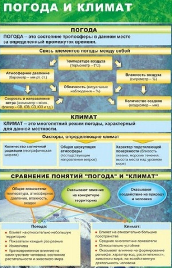
What is weather?
Atmospheric indicators are constantly changing. Never permanent:
- pressure,
- temperature,
- humidity,
- precipitation,
- atmospheric phenomena,
- visibility range,
- wind direction and strength,
- cloudiness,
- optical and electrical phenomena.
In science they are called meteorological elements.
Weather is the state of the troposphere at a certain period of time (at a given moment in a given place) over any point or region of the globe.
It is characterized by certain values of meteorological elements, which are constantly monitored at meteorological stations. The main characteristic of weather is its variability and diversity. And the main reasons for weather changes are the movement of air masses, the axial and orbital rotation of the Earth.
Signs of a change from clear to stormy weather
The pressure drops and the faster, the more accurate the sign.
temperature always rises in winter, and decreases in summer. The difference between day and night temperatures: sometimes it becomes warmer in the evening than during the day.
The wind increases, diurnal fluctuations weaken or disappear completely. If, as the pressure drops, the wind intensifies and hardly changes direction, the cyclone should pass through its center. In this case, after a temporary lull, we should expect the wind to resume from the opposite direction.
Cloud cover is increasing. Change of clouds: cirrus clouds appear in the west.
The faster the clouds move, the sooner severe weather occurs. If in the evening, after a clear day, the clouds begin to thicken and thicken, expect rain or a change in weather.
Precipitation. There is no dew at night, and there is fog in the lowlands.
Atmospheric phenomena. The stars twinkle strongly. The sun sets in a cloud, above which cirrus or cirrostratus clouds are visible. Evening and morning dawns are bright red.
Weather changes
The weather changes constantly; there are almost no two days with exactly the same indicators. Even at the equator, tropics and poles, where the weather is relatively constant, it changes throughout the day. But without going into details, we can distinguish general types of weather.
- Dry, clear, devoid of precipitation, frosty in winter, hot in summer. With a few clouds that do not cover the entire sky. Similar weather occurs in an anticyclone.
- Unstable weather, when alternating clearings, heavy downpours, rain and thunderstorms or snowstorms. It is observed inside a cold air mass, in the rear part of cyclones, and less often on the periphery of anticyclones.
- Cloudy, but without heavy precipitation. Stratocumulus or stratus clouds cover the entire sky, sometimes accompanied by drizzle or fog. Such weather is typical for a warm air mass in the warm sector of a cyclone or in the branches of anticyclones, especially in winter and autumn.
- Inclement weather with continuous heavy rain or snow brought by cyclones.
Weather changes can be periodic or non-periodic. Periodic changes depend on the rotation of the Earth around its axis and the Sun. For these reasons, there are daily and seasonal fluctuations in temperature, humidity, prevailing winds and other meteorological indicators. Daily changes are especially good to observe on clear days:
- The minimum soil and air temperatures and the highest relative humidity occur before dawn. Before sunrise, the wind dies down, dew may fall and fog may form;
- when the sun rises above the horizon, the dew evaporates, the fog dissipates, and the wind begins to blow;
- The highest temperature is typical for 13 o'clock.
Non-periodic weather changes are caused by the movement of air masses from one geographical area to another in the general circulation of the atmosphere.
Signs of stable clear weather (for the middle zone)
Page 1 of 3Next ⇒Pressure: for several days slowly and continuously rises or remains consistently high. The air temperature in summer is high during the day (hot), at night it drops noticeably (fresh, cool), in winter it drops greatly at night (frosty), during the day it rises (the frost weakens somewhat); at night it is much warmer in the forest than in the field; it is warmer on a hill or higher ground than below. Wind . calm at night, increases significantly during the day, but subsides in the evening; on large lakes and reservoirs, in the mountains and near forest boundaries, local winds (with regular changes of direction) prevail. 0cloudiness : the sky is predominant. clear, cloudless; In spring, summer and autumn, cumulus clouds may appear in the morning, which increase in size in the afternoon and disappear (melt) in the evening - the so-called. fair weather cumulus clouds (Fig.); the movement of clouds coincides with the direction of the wind at the earth's surface; sometimes in the morning high, seemingly motionless cirrus clouds are visible, which disappear in the evening; In winter, the sky is cloudless during the day and by evening it can be covered entirely with low stratus clouds. Precipitation : absent, at night, before dawn, heavy dew or frost falls, which quickly evaporate after sunrise; In the hollows and lowlands, fog forms in the evening and at night, disappearing after sunrise. Atmospheric and other phenomena : the dawn is usually golden or pink; a green dawn is a harbinger of the onset of a long period of dry weather (in summer), a yellowish-brown dawn indicates a continuation and even intensification of frost (in winter); dry fog or haze, as well as a silvery glow without clear boundaries, observed in the west for long periods. time after sunset with a completely clear sky; strong will continue. northern lights - to frost; smoke rises upward in a column; near the Moon, rather large crowns (but not circles) are formed in the clouds; the stars twinkle faintly green. Swallows and swifts fly high; in autumn there is a massive fly web; Spiders go hunting in the evening.
Signs of a change from clear weather to stormy weather.
Pressure : decreases, the faster - the more certain the onset of bad weather; after passing through cold atmosphere. front pressure increases. air temperature : rises in winter (some warming occurs); in summer the difference between day and night temperatures decreases; it is warmer in the evening than during the day. Wind : increases, especially in the evening; the correct daily changes in local winds are disrupted; the direction of the wind changes clockwise (if the center of the cyclone passes north of the observation site) or counterclockwise (if the center of the cyclone passes south of the observation site, in this case precipitation is not expected); if, with decreasing pressure, the wind intensifies, almost without changing direction, then the center of the cyclone will pass through the observation point, and in this case, after a temporary lull, we should expect the wind to resume, but from the opposite direction. 0 cloud cover : increases, clouds move in the opposite direction or perpendicular to the direction in which the wind blows at the earth's surface, the faster the clouds move, the sooner bad weather will occur; in the west, first cirrus clouds appear, then cirrostratus clouds (moving quickly, noticeable to the eye), they are joined by altostratus clouds, turning into stratus and nimbostratus (this change of clouds is typical for the passage of a warm front and the associated cyclone, which is more often everything happens in autumn and winter, foreshadowing long-term drizzling rains and snowfalls); a characteristic sign of the approach of a cyclone is a fan-shaped arrangement of cirrus clouds coming from the west; if it is clear during the day, but in the evening the clouds thicken and thicken, then rain or a change in weather should be expected; wavy (altocumulus) clouds, reminiscent of ripples or crests of waves on the sea, are a sure sign of the onset of inclement weather within a few minutes. h; the appearance of clouds in the form of lambs also portends imminent bad weather; cumulus clouds torn to shreds indicate the approach of a stormy, windy P. Precipitation does not include dew at night; ground fog, dew or frost formed in the evening disappear before sunrise. Atmospheric and other phenomena: distant objects are clearly visible, especially in the mountains; stars flicker strongly in red and blue, especially in the morning; The sun sets in a cloud, cirrus or cirrostratus clouds are visible above the cloud; the crowns around the Moon have a small diameter; morning and evening dawns are distinguished by a particularly bright red color; the day following the red evening dawn there is usually no precipitation, only the wind increases; the audibility of distant weak sounds improves; the smoke spreads almost horizontally. The smell of flowers and fresh hay intensifies. Swallows and swifts fly low above the ground; spiders hunt in the morning.
Signs of persistent inclement weather.
Pressure : low (up to 730 - 740 mm Hg above sea level), changes little or continues to decrease throughout the day. Air temperature is constant throughout the day, relatively high in winter, moderate in summer. Wind: strong, in
During the day, almost always changes directions, most often south-west, less often south-east, east and north-east.
Cloud cover: in winter, continuous stratus and nimbostratus clouds; in summer it is continuous, sometimes with breaks. Precipitation: light snow or light drizzle, falling continuously for a long time. time (precipitation of a warm front), or more intense, with interruptions (precipitation of a cold front); dew and frost do not fall. Atmospheric and other phenomena: good visibility if there is no rain or snow;
distant faint sounds are clearly audible; will continue. twilight. Signs of improving weather.
Pressure : for several days it increases slowly, but continuously or quite quickly - in this case P. improves for a short time. air temperature decreases significantly, and when moving from north-east to north-west it changes little; In summer, such a change in P is often preceded. decrease in temperature (during the passage of a cold front); daily temperature fluctuations increase. Wind : southwest or northeast changes to northwest, becomes more gusty (which indicates the passage of an atmospheric front). 0cloudiness :
preim.
variable, at times the entire sky may be covered with low nimbostratus clouds, but in the evening, clear skies form in the west; cirrus clouds of bizarre shape appear, disappearing in the evening; if, as pressure increases, the sky quickly clears and the wind subsides, then P.’s improvement will be short-lived. Precipitation : It can rain or snow quite heavily at times, but there is no continuous precipitation.
Signs of an approaching thunderstorm.
Pressure : fluctuates or slowly but steadily decreases Air temperature: increases with light winds and soars during the day. 0cloudiness cumulus clouds appear early in the morning, develop intensively, taking the form of towers or anvils, and do not dissipate in the evening: if in the morning altocumulus clouds move quickly across a clear sky in
in the form of towers or pillars, then a thunderstorm should be expected in the afternoon;
if thunderclouds have the shape of individual narrow and high towers, then the thunderstorm will be short-lived with rain; if the clouds pile on top of each other, forming mountains with a dark base, then most likely the thunderstorm will be severe; If on a warm and stuffy evening the sky is covered with a continuous veil of clouds, then most likely there will be a thunderstorm at night. Atmospheric and other phenomena: distant faint sounds are clearly audible;
spiders go hunting on a hot afternoon. Lit. Pocket book of a naturalist and local historian. Ch, 1961, Adamov P.N., Local signs of weather, L. 1961, Shepfer E, What will the weather be like, translated with him, L, 1963, Weisberg D., Weather on Earth, translated from English, L 1980; Danilova N A, Climate and recreation in our country M, 1980, Astapenko P D, Questions about the weather, 3rd ed. L 1987
THRESHOLD
river, a section of a river with a relatively large drop in water level and increased flow speed. It is formed, as a rule, in places where a river crosses rocky ridges, outcrops of hard-to-erode rocks, accumulations of boulders, rock fragments, etc. Simple P, found already on water routes 2 - 3 KS. The characteristic elements of the river are weirs, which, depending on the angle of incidence of the water, are more than 45′, approx. 45′ or less than 45′ – divided accordingly. to waterfalls, water slides and just plums
Drains are usually the freest place from stones and therefore the most passable place in the P. Most drains have the shape of a triangle formed by the line of inflection of the water flow and oblique streams from the rocks limiting the drain at the base. Converging streamers of jets cause the appearance of standing waves (see Wave
standing) or chains of waves behind the vertex of the triangle.
In P. there may be one drain across the entire width of the river or several drains of different types. height and thickness, separated by protruding rocks or stones. If P. consists of several. consecutively located drains, the distance between which invariably exceeds
the length of the vessel, then such P is called.
single stage; if between discharges the ship can freely maneuver and pass from one bank to the other, then P. is called. multi-stage, There are straight and oblique drains: for a straight drain, the inflection line of the water flow is perpendicular to the river flow;
at an oblique one, it forms an acute angle with the flow of the river. A narrow oblique drainage, in which the depth of the channel at the inflection line differs greatly from different banks, is called. twisted or screw. When determining the possibility of passing the P., the characteristics of the discharge, the seaworthiness of the vessel and the preparedness of the crew are taken into account. The easiest tour to complete. ships - P. with direct discharge; the most complex and dangerous is with a twisted drain. Single gently sloping straight drains and waterfalls are passable for tours. ships of all types. On small rivers it is recommended to stay on average. the line of a triangle formed by converging streams of flow, since here the depth is usually greater and the channel is cleaner. On large rivers, you should avoid moving through the top of the discharge triangle, i.e., this is where the greatest danger for the vessel is to be capsized by steep standing waves. If the result is preceded. After inspecting the P. (and such an inspection is mandatory, especially for those who are going this route for the first time), doubts arise about the success of its passage, it is necessary to surround the ships (see Obnos) or guide them along the shore.
Lit.: Travels on rowing ships, M., 1979.
ABRASIONS
local inflammation of the skin caused by mechanical irritation most often lasts. friction, pressure from incorrectly selected and fitted shoes, clothing and other equipment. Increased sweating predisposes to the appearance of P. On tour. During hiking, P. are most often observed on the feet (fingers, heels, ankles), palms, back and shoulders. P. initially manifests itself as a burning sensation, soreness, redness of the skin in places of pressure and friction. With further irritation of the skin, blisters with transparent contents form (the so-called water callus), which can fester. After opening the blisters, erosions remain, which can also be complicated by suppuration.
For moderately severe redness, the skin is washed with a 5% aqueous solution of tannin or a 2% solution of boric acid, or lubricated with 1 - 2% alcohol solutions of brilliant green or methylene blue. In case of severe pain, you can apply a bandage with zinc paste or emollient cream (“Children’s”, etc.). Bubbles cannot be dug out. If they break out on their own, you need to wash the affected skin with the disinfectant indicated above. remedy and apply a dry bandage.
To warn P., it is necessary to select the right equipment, adjust it and check it before going out on the route. During a hike, it is necessary to take into account changes in weather conditions and accordingly change clothes and the pace of movement, avoiding overheating of the body , movement in damp clothes, which are not justified by the situation of forced marches. Having discovered the slightest inconvenience in the equipment, you need, without waiting for P. to appear, try to eliminate the reason by changing clothes, changing shoes, changing socks, adjusting backpack straps, etc. As a preventive measure. Measures you can bandage your feet with an elastic bandage, wear gloves (while rowing), put soft things between your backpack and your back, etc. Regular skin care is important (fighting sweating, washing your feet daily with cool water, etc.).
PRIVAL
short tour stop groups in
hiking for rest, lunch, medical care.
help, etc. When moving along a route, P. is usually arranged (depending on the difficulty of the transitions and the condition of the group members) for a duration of 5 to 20 minutes every 30 to 50 minutes (small P.); The duration of the P. for lunch ranges from 30 minutes to 2 - 3 hours (large, or lunch, P.). During the P., tourists record hiking observations, carry out minor repairs to clothing and equipment, conduct reconnaissance of the further route, etc. Place P. ... is selected taking into account the convenient and safe placement of the group, close to sources of drinking water, observation points, etc. See also Bivouac.
PRESS
the rush of water onto a steep (usually rocky) bank at a bend in the river under the influence of centrifugal forces. As a result of the transverse displacement of water directly near the shore, a local increase in its level occurs with strong surface currents characteristic of the beach, directed from the shore, which can throw away (prevent being pressed to the shore) a light vessel with a shallow draft drawn into the river. If the rocky (pressure) shore has a negative. angle of inclination or underwater “pockets”, then all surface water goes deep. Such Ps are the most dangerous - they are difficult to detect. and their addictive effect is very great. A related obstacle to P. is the blockage of accumulation of various objects, ch. arr. tree trunks, in the river bed. On small taiga rivers, as well as in severely narrowed areas of the channel, blockages can exist for years. The blockage is dangerous due to suction - water that can lead to a revolution. vessel. When approaching the dam, the vessel should be taken out of the water and dragged along the blockage.
Lit.
Travels on rowing ships, M, 1979
WIRING
movement of vessels through places dangerous for navigation (rapids, rifts),
usually by means of ropes tied to the bow and stern of the vessel. It is carried out by the entire group of participants in the water trip, with one or more. tourists are held by a rope tied to the part of the vessel that is most loaded with the flow (the one upstream, usually to the stern); one holds the bow end of the rope, the rest belay. If the section is long, P. is preliminarily done. reconnaissance During sailing, the angle between the direction of the current and the stern end of the rope should be minimal. Sometimes, with a sharp increase in this angle and the impossibility of holding the stern, it is necessary to release (bleed off) the stern end so much that the vessel turns stern forward (at this time it is held by the bow end). This turn prevents the boat from flooding with water or turning it upside down. In short sections with good passage along the shore, it is allowed to sail the vessel with one tourist at the stern end, while another tourist helps the vessel at this time, pushing the ship away from the shore or pulling it with an oar or pole.
During P., the vessel may be flooded with water, so all the cargo in front of P. is placed in waterproof packaging, and the cockpit of the kayak or boat is covered with an apron. Tourists performing P. must be in rescue mode. vests and helmets, wear shoes that do not slip on rocks. The belaying boats keep their throwing lines ready at any time so that they can intercept the lines tied to the ship at any time (if it is impossible to walk along the shore, for example, because of steep cliffs, large stones, etc.).
Lit.: Travel on rowing ships, M., 1979.
ROUTE PROFILE
(from Italian profilo – outline), a drawing depicting a section of the area with a vertical plane; gives a clear idea of the nature of the relief in the chosen direction. When constructing linear maps, points with known heights are marked on the horizontal axis, perpendiculars are restored in them, the length of which corresponds to the height of the points, and the vertical scale is taken much larger than the horizontal for a more visual display of relief details (for example, beams, river terraces). . In this case, there is an inevitable exaggeration of the steepness of the slopes. The line connecting the ends of the perpendiculars represents the P. m. (Fig.). It can be built using a map with contour lines
or based on field measurements. Abbreviated P. m. are also compiled, in the construction of which only the boundaries of ascents and descents and places of sharp bends of slopes are taken into account.
RIVER PASSABILITY
minimum quantities. and qualities. information about the river that determines the possibility of rafting on it for a tour. ships and the approximate category of route complexity. It is determined by its water content, or average water flow (in water T. measured in m'/s), and the average slope of the river, as well as the maximum values of the slope. its sections (measured in
m/km). For tour vessels available rivers from Wed. slope up to 15 m/km and slopes apart. sections up to 20 - 25 m/km, with average water flow rates of no more than 25 - 35 m3/s.
Unlike Wed. The slope of the channel, which is a constant value, water flow varies throughout the year. To carry out rafting on a mountain river with acceptable water consumption values, it is necessary to choose the time for the hike. Thus, in the Caucasus, rivers are most often traveled in spring and autumn, in the Pamirs and Tien Shan - in autumn, during the period of lower water flows, because at high flows, rafting on these rivers means. the slope of the riverbed becomes dangerous. Information about the nature of the river valley will help clarify the possibility of rafting. Taiga and lowland rivers from Wed. a slope of no more than 1 - 2 m/km, as a rule, are available for rafting 40 - 60 km from the source, where cf. water flow can be very small, about 3 - 6 m'/s; the possibility of rafting along them is determined by Ch. arr. the number and nature of forest debris.
Lit.:
Travels on rowing ships, M., 1979
TRAVEL LEADER
(travel), the most experienced and authoritative participant in the campaign (travel), who is elected by the general meeting of the tour. groups. Heads its preparation and implementation, is responsible for the safety and successful completion of the route. Supervises the preparation of the necessary equipment and food, carefully studies the region and route of the hike and introduces them to all participants. The tasks of the R. p. are to ensure optimal. tourist group schedule
comfortable on the route and favorable psychological conditions. climate in the team. After returning from the hike, R. p. prepares a report on the hike and submits it to the tour. org.
Lit:
Kudinov B.F., Organization of tourist work at an enterprise, M, 1964, Stuk
ov
G,
What
for ” , “Tourist”. 1987, M No. 4
SELF-CONTROL
tourist, assessment of his physical. conditions during training and on the hike. Its purpose is regular monitoring of physical exposure. loads on the body, well-being, performance, sleep, appetite, etc., in order to make adjustments to the training and hiking regimen if necessary. It is carried out on the basis of subjective sensations and simple objective indicators.
Subjective sensations (well-being, mood, appetite, degree of performance, etc.) reflect not only physical. condition, but also the correct distribution of the load: when overloaded, well-being worsens, fatigue and irritability appear, sleep and appetite are disturbed. Objective indicators of S. allow more accurate dosing of physical therapy. load and determine the degree of fitness. Thus, the heart rate (calculated at the wrist, neck, temple) during training and on a hike should not exceed 75% of its maximum. age value (220 minus age), Another objective indicator is the so-called. pulse recovery, i.e. the time it takes for the pulse rate to return to its original value. In trained individuals, after exercise (20 squats), the pulse is restored no later than 5 minutes.
During a hike, you must not miss the appearance of signs of overwork: fatigue, which occurs earlier or with less load than before, and does not go away after a night's rest; irritability, which can cause minor conflicts. about; shortness of breath and palpitations
peace;
sometimes - night urination (if previously absent). These signs require unloading or rest ( day rest),
as well as increased attention to safety measures.
SELF-INSURANCE
insurance carried out independently using individual safety equipment, without the help of other group members. S. is used in all types of tourism, but most widely and variedly in mountain tourism and speleotourism. The importance of S. is especially great when hiking along complex terrain, replete with steep slopes, glacial crevasses, rock walls, screes, etc. A distinction is made between passive and active S. Passive S. is provided by clothing, shoes, and other things. devices that protect tourists from injury (for example, a protective helmet, goggles
protective and
windproof
mask, mittens,
storm suits, vibrams,
inflatable vests, car seat belts).
Active S. provides for the tourist to fulfill certain requirements. actions, tech. techniques (for example, correct positioning of feet on an ice slope or scree, knocking out and loading steps, as well as constant readiness for self-arrest), usually with the use of special safety
equipment
(tourist rope
, ice ax, ice rope,
alpenstock, crampons, pitons
and etc.). For individual movement (for example, during competitions), both types of S. are used; when moving as part of a group, S. is combined with group and mutual insurance.
Rice.
1. The procedure for fastening the carabiner at the fastening point when moving along the railing with a self-belay.
For example, when moving individually on a steep slope along a railing rope, S. is carried out using the end (loop) of a rope or parachute line connecting the safety harness
tourist with railings.
Having fallen, the tourist hangs on the safety end, retaining the ability to independently restore balance and take the position before the fall. Its length is chosen so that in the event of a fall, the belayer can freely reach the railing rope with his hand. It is unacceptable to use safety ends made of cords with a thickness of 5–6 mm. The safety end is attached to the harness with a knot, and to the railing rope with a carabiner
(when moving along horizontal railings), a grasping knot or a clamp (see Grips). To attach the safety end to the steel cable railings, special clamps are used. structures (for example, “reflex” clamps) that eliminate the possibility of the cable being bitten at the moment of a jerk when the belayer falls. 8o while moving, the carabiner, grasping knot or clamp is moved along the railing rope, holding it with your hand and ensuring that. permanently operating C. Having reached the intermediate point of fastening the emergency rope, the safety end is re-fastened to the next section of the railing (Fig. 1).
Rice.
2. Organization of self-insurance during mutual belay of a partner in a rope: a – using the main rope, b – with fastening the safety end on one hook above the safety harness; c –
with fastening the safety end on two hooks – above and below the safety harness.
When moving as part of a group on rocky terrain with mutual belay, it is recommended for S. to use the main. rope, laying it behind rocky ledges in order to hold on and not lose the balance of a piece of rope at the moment the belayed partner falls. When moving in tandem on a closed glacier
S. is ensured strictly. maintaining a distance between partners in the rope for the entire length of the rope.
When performing mutual insurance, insurance is organized so that it does not interfere with the implementation of the basic requirements. safety actions, taking into account the direction of a possible jerk and terrain features. S.'s action should always be directed in the direction opposite to the direction of the expected jerk. For example, when jerking downwards, the point of attachment of the belay end should be higher, and when jerking up – below the belayer’s chest harness; if possible, the safety end is secured to 2 hooks driven above and below the level of the chest harness (Fig. 2). The most preferable organization is the use of anchorage points independent of the partner's lower belay point, or combining them by blocking.
Lit.
cm, at st.
Insurance.
VILLAGE
(from Arabic sayl - stormy stream), force, mur, mud or mud-stone flow, suddenly appearing in the beds of mountain rivers as a result of a sudden flood caused by heavy rains or intense snow melting in conditions of the accumulation of a large number of weathering products on the slopes. Usually seen in
mountain and foothill regions with a continental climate. It is characterized by a sharp short-term (1 - 3 hours) rise in the level of the flowing mass and its pulsating movement in the absence of strict periodicity.
Tourists can encounter mudflows in all mountainous regions of Russia. Federation, as well as in the mountains of Sr. Asia, South Kazakhstan, East, Transcaucasia. Sometimes S. occurs in the beds of mountain rivers and streams, which are usually dry. Signs of the possible formation of water are: a rapid increase in the water content of rivers and streams, the appearance of soil in them, the movement of small screes soaked in water, and landslides. If these signs are present, tourists should leave the narrow gorge, climb the tongue of the glacier or a high terrace, a gentle slope or a simple side ridge. If the group was in a safe place, it should wait until the water level in rivers and streams stabilizes. Since S. occurs mainly in the evening and at night, it is impossible to arrange a bivouac
in mudflow-prone areas (on low banks of rivers, in hollows, on mountain slopes and on so-called alluvial cones - accumulations of pebbles, fishing line, clay, usually in the lower part of a couloir, ravine or valley)
Lit.:
Mudflow-prone areas of the Soviet Union, M 1976; Vinogradov Yu.B., Sketches about mudflows., Leningrad, 1980
SLOPE
a sloped area of the earth's surface, usually between the bottom of a valley and the crest of a ridge or top of a mountain. A set of S., united by a common bias, called. slope (for example, southwest slope of the Greater Caucasus). S. can be straight, convex, concave, and stepped (terraced); Based on the nature of the surface, soils are classified as forested, grassy, scree, rocky, snowy, firn, and ice. Dept. species of S. called slope, slope. On tour. and alps. In practice, slopes are characterized by width, length, and steepness. The steepness of the slope is an important indicator on which the choice of insurance
and tactics of movement along the north. There are flat roads (up to 20′), cf.
steepness (up to 30′), steep (up to 45′) and very steep (up to 60′). N. steepness of St. 60′ naz. walls; for short lengths (up to 40 m) - walls. As a rule, insurance is not required to move along the flat north (with the exception of closed glaciers); if a tourist falls, he remains in place or easily performs self-arrest. In the north wed. steepness , self-insurance is necessary,
as well as mutual insurance when self-arrest may be ineffective, for example.
on ice, near a crack or fault. On steep slopes, mutual insurance is required; When driving along very steep slopes, the entire arsenal of mining equipment is used, and the belay is usually a railing. Walls and walls on tour. routes are rare; As a rule, they are objects of mountaineering
and
rock climbing.
Visual assessment of the slope of the slope usually gives inflated results. The steepness of the S. can be assessed using an ice ax or alpenstock
or a ski pole (Fig. 1). The error in determining the steepness of the north in this way increases sharply if the north is covered with deep snow (Fig. 1, e).
To more accurately determine the steepness of the north, use a protractor or compass. As a rule, tourists on hikes use liquid compasses for sports. orientation. The compass is installed so that the N–S line is perpendicular to the long side of the compass stand. The stand is oriented along the S., with the air bubble located at the top. parts of the compass against the scale division, indicating the angle between the N–S line and the vertical passing through the middle of the bubble and the axis of the compass needle; this angle corresponds to cf. steepness of the N. (Fig. 2).
Rice . 1. Determining the steepness of the slope using an ice ax, ski pole or alpenstock with a steepness of 300 (a), 450 (b), 600 (c), 75 - 800 (d) m in deep snow (e); 1 -
slope surface; 2 – ice ax; 3 –
snow cover; / – arm and ice ax length.
Rice. 2. Determining the steepness of a slope using a liquid compass: 1 –
compass scale;
2 – air bubble; 3 – stand: 4 –
line of sight of the compass (slope surface);
5 – compass needle; a is
the steepness of the slope.
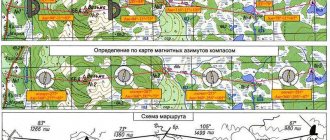
MAGNETIC DECLINATION
angle between geogr. meridian and the direction of the established magnetic needle (magnetic meridian) at a given point. When the north direction deviates. of the end of the magnetic needle to the east, the declination is considered eastern (positive), with a deviation of 3 – western (negative) (Fig.). Knowledge of the magnetic field is necessary when orienting a map using a compass and determining the magnetic azimuth of directions on the map.
Magnetic needle declination and azimuths.
TETANUS
acute infection a disease with severe damage to the nervous system, caused by a bacterium (tetanus) when it enters the body through damaged skin or mucous membranes; widespread everywhere. preim. in agriculture district Tetanus bacillus lives in the intestines of herbivores and humans, without causing disease, and enters the soil with their feces, where it can persist for years. Most often, S. occurs after injury to the legs while walking barefoot (“bare foot disease”); It usually develops 5–14 days after infection and manifests itself in painful attacks. seizures; often ends in death. Prevention of S. is carried out for children and adolescents in the form of active immunization with tetanus toxoid. Tourists vaccinated against S. St. 10 years ago, before going on a hike, you should contact
clinic for re-immunization.
It is not recommended to go barefoot while hiking, especially in areas where livestock is grazing. For any damage (wounds, including bites, burns, minor abrasions), careful treatment of the wound with an antiseptic is necessary. means and applying a sterile dressing. Under no circumstances should soil or plants be applied to the wound. In conditions of long hike if available for the tour. medical group It is advisable for a worker to have tetanus toxoid in the first aid kit for emergency prevention: in case of injury to a tourist vaccinated with St. 2, but less than 10 years ago, he was injected subcutaneously with 0.5 ml of toxoid.
INSURANCE
a set of measures to ensure the safety of tourists on a hike; in a narrow sense - a set of technologies. means (and methods of using them) that provide the ability to prevent severe consequences in the event of breakdowns and accidents. There are three types of insurance: group insurance, mutual insurance and self-insurance. Group (or mass) insurance is designed to ensure the safety of a large group of tourists by constructing railings at crossings and steep mountain slopes, fences on narrow dangerous routes, etc. Mutual insurance is the main thing. type S. for groups (crews) of 2 – 4 people. The goal is interaction to prevent crisis situations (for example, breakdowns, accidents, loss of orientation), aimed at supporting the partner using safety equipment and special equipment. tech. techniques. Self-insurance is carried out using individual safety equipment without interaction with other group members and, therefore, at least wears prophylactic. character. The type of S., the techniques and safety equipment used depend on the type of T., the complexity of the route, the nature of the obstacles, and the climate. conditions, number of tours. groups, etc. S. is most widely used in mountain, water, and speleotourism.
Rice. 1. Location of the railing: a – inclined. b – horizontal, c – vertical
Rice. 2
Simultaneous insurance.
Rice.
3.
Variable insurance.
Rice.
4. Methods of organizing belay: a – top belay from above;
b – top belay from below; c –
lower belay; d – steam room double-sided belay.
Fig 5a Fig 5b
Rice.
5. Position of the belayer: a – belay over the shoulder with support on the ledge; b – belay through the lower back with support on the ledge; c –
combined belay over the shoulder and hook;
d –
belay through a ledge with high friction: d – belay through a ledge with medium friction;
e – belay through a ledge with low friction; g –
belay and self-insurance using an ice ax; h – belay in a sitting position with self-belay for a rock ledge.
S. in mountainous terrain is determined by the specifics and conditions of hiking in mountainous areas: difficult terrain (steep slopes, walls, cracks, glaciers, screes, stormy mountain rivers), possible rockfalls, snow avalanches, mudflows, landslides and ice collapses, which means. temperature changes, increased solar radiation, decreased atm. pressure and oxygen deficiency, etc. To minimize health hazards to travelers
mountains, used various S.'s means, which can be divided into organizational, preventive and technical. The first include special training, medical control, competent route planning, constant monitoring of the environment in order to detect an avalanche, the beginning of a rockfall and other natural phenomena as early as possible, choosing a reliable shelter, providing assistance to victims, proper organization of a bivouac.
The basis of technology means S. is a rope attached using knots, carabiners,
clips, etc. to
harness
on the body of the insured and to
hooks,
eyes, rocky ledges, trees, etc. The rope keeps the insured from falling in the event of a fall, serves as a railing when crossing a river, ravine or crevice; they climb and descend using the rope when overcoming walls.
Individual short (up to 3 m) sections of steep rocks or ice, where there is no danger of falling to great depths, can be overcome with the so-called. gymnastics S. (similar to how a coach supports a gymnast on a gymnastic apparatus). On complex steep sections, in order to increase the reliability of movement along the railing, in some cases (in bad weather, fatigue, malaise, etc. ), mutual upper S. with a second rope is used.
1Next ⇒
Weather forecasting
The science of meteorology deals with the preparation of accurate weather forecasts. She knows many of the secrets of nature, she can explain natural phenomena and predict them in advance. The accuracy of forecasts depends on the breadth of the observation network - the number of weather stations in all corners of the Earth, on the accuracy of the instruments used there and on the close interaction with the World Weather Watch.
There are about 20 thousand weather stations in the world, about 2 thousand in Russia. They take readings from all instruments 8 times a day and send the data to weather centers. Information from research ships, airplanes, and artificial Earth satellites also comes there. The centers compile synoptic maps (weather maps) several times a day, combining all the information received. Scientists are already making predictions using these maps.
Weather forecasts can be general or special. We learn the general forecast from the media. Special forecasts are made taking into account the types of economic activities. For example, weather forecasts for aviation include data on the lower limit and thickness of clouds, visibility, turbulence, fog, and wind at high altitudes.
The Russian Special Weather Service was created in 1872. The central weather service authority in our country is the Hydrometeorological Center, located in Moscow. It is one of three world centers of the World Weather Watch. The other two centers are located in Washington (USA) and Melbourne (Australia).
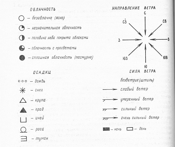
To keep weather diaries, you can use the following symbols:
This is interesting
The first radiosonde in Russia was launched in January 1930. It automatically measured pressure, temperature, wind direction and speed and transmitted everything digitally to the ground. The radiosonde was created by the observatory scientist Professor P. A. Molchanov.
Molchanov's comb radiosonde was used for 25 years; it, of course, was improved, but retained its basics. It was used during the Great Patriotic War, during Arctic research and in everyday work. It was used not only in Russia.
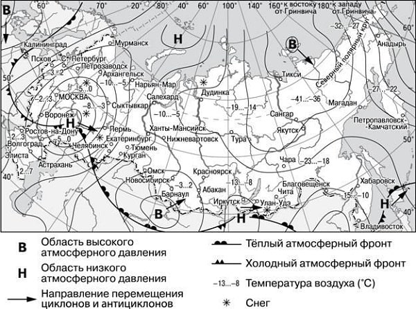
Synoptic maps
A synoptic map is a type of geographical map on which data for a certain point in time is plotted with symbols and numbers. Using general weather maps, you can trace the direction of movement of air masses and fronts, the development of cyclones, etc. There are also auxiliary synoptic maps. They reflect individual indicators and phenomena: maximum temperatures and precipitation for the day, fog, thunderstorms, etc.
Aerological diagrams, graphs, radar maps, and satellite images are also used to analyze atmospheric processes and weather forecasts.
Analyze the synoptic map, study its legend and answer the questions.
Weather forecasting based on local signs
People have accumulated many superstitions that predict the weather, based on observations of nature. They noticed that plants and animals react to changes occurring in the atmosphere. Even minor changes in pressure are acutely felt by insects, spiders, some birds, and fish.
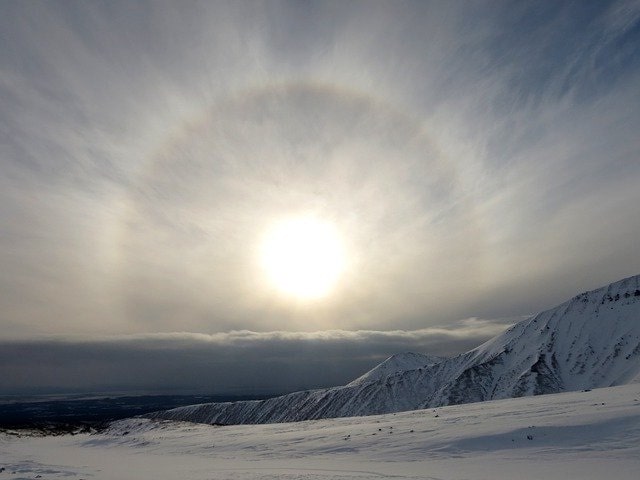
A number of weather signs are based on human observation of optical phenomena in the atmosphere (color of dawn, rainbow, etc.). So, on one of the clay tablets that came to us from Babylonia, you can read: “If the sun is surrounded by a circle, then rain will fall.”
In the book “Toilers of the Sea,” Captain Gertre, having learned that Cluban was going to sail on his “Durand” tomorrow morning, said to him:
“...If I were you, I would stay. Listen, Captain Clubin, dogs smell like wet dogs. Seabirds have been hovering around the lantern at the lighthouse for two nights. The omen is bad. My barometer is playing tricks. Now the moon is in its first quarter, and at this time the weather is damp. Today I saw how the foliage curled up its leaves, and the clover in the field straightened its stems. Earthworms crawl out of the ground, flies bite, bees do not fly away from the hive, sparrows seem to be holding advice. The ringing of bells can be heard from afar. Moreover, the sun had set behind the clouds. Tomorrow there will be healthy fog. I don't recommend swimming. In my opinion, fog is worse than a hurricane. You can’t guess what’s on his mind.”
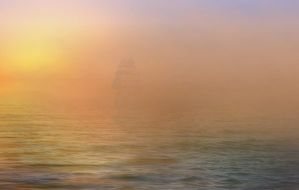
Fog at sea
Clubin, who was up to no good, did not heed the captain’s benevolent advice: “Duranda” went out to sea, found herself in a continuous fog and ran into a rock.
Folk signs have not lost their relevance in the age of space exploration and the rapid development of science and technology. Weather signs, which are the result of many years of observations, proven by the practice of peoples and scientifically based, need to be known at least in order to understand the difference between the scientific approach and prejudices, fiction, and superstition.
When making a weather forecast based on local signs, you should remember that you need to compare several signs, and not stop at one. If all the signs confirm each other, then the forecast becomes more likely. Local signs make it possible to make a forecast several hours in advance, and sometimes a day or more.
Signs of clear, dry weather
The source of this information is A. Roshchin’s book “Your Own Forecaster.”
On winter nights the sky is clear, but in low elevations fog is possible : during the day it rises, dissipates, and the sky remains cloudless. In summer, it is either clear, or around 10 am, small cumulus clouds of “fine weather” appear scattered across the sky, like wisps of cotton wool. By 15...16 hours their number increases, and by evening they disappear without a trace.
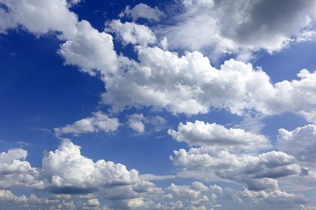
If there are no cumulus clouds, the sky remains cloudless all day - this indicates that there will be stable, dry, very warm and even hot weather.
In summer, on clear nights, the air cools greatly, and low fogs appear, spreading along the ground, usually over swamps, rivers, hollows, and lowlands. After sunrise, the night fog lifts and sometimes turns into broken stratus clouds. The morning seems cloudy, foreshadowing a stormy day, but by 9...10 o’clock the clouds clear and the sun shines again. Night fog is typical for established clear weather.
In clear weather, the daily variation in air temperature is clearly visible. It rises from sunrise to 14...15 hours, and then continuously decreases until the morning of the next day. At night it is warmer in the forest and on the hills than in the fields and lowlands. In winter, we feel how the frost “gets stronger” in the morning.
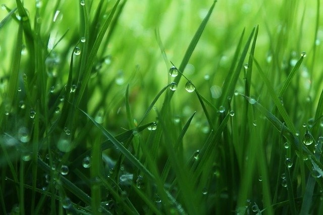
In summer, soon after sunset, dew falls on the grass , which disappears only after sunrise. According to popular belief, abundant dew means a clear day; in the morning dew and fog - good weather; the more dew, the hotter the day will be.
Dew can be explained in the same way as the fogging of a cold object brought into a warm room. The earth cools faster than the air at night. Water vapor contained in the air, in contact with the surface of the earth, condenses. Therefore, folk weather signs based on long-term observations of dew formation are quite correct.
Dew
Smoke coming out of stoves and factory chimneys contains, in addition to gaseous products, tiny solid particles remaining after fuel combustion. These particles make smoke visible. In stable, quiet, clear, dry weather, the smoke rises vertically.
When long inclement weather changes to clear, dry weather, the smoke also rises or with a slight slope towards the wind.
In stable, clear weather, the wind is light, without sudden changes. The night is quiet. In the morning the wind appears. By noon it intensifies, and in the evening it weakens again. This portends good weather. If the wind blows from the sea to the land during the day, and in the evening from the land to the sea (breeze), wait for good weather (during the day the land heats up faster, the air above it becomes lighter and is displaced by less heated air from the sea; at night the land cools down faster and the wind changes direction ). This change in wind occurs on the coast of seas, large lakes and rivers in the summer.
The clear blue color of the sky in winter is one of the signs of stable clear weather.
A sure sign of continued clear weather is a clear sunset , turning from yellow (at the horizon) to golden pink and then green. The greenish color of dawn portends prolonged dry weather, and if very noticeable, then drought. Folk signs also speak about this: a clear sunset means good weather (dry weather); if you see a green ray, expect a good day tomorrow.
All these signs are characteristic of stable weather, that is, of a homogeneous air mass that lingers over an area for several days. There is no wind (it appears only during the day as a result of strong heating of the soil by the sun), and for the same reason, evaporation from the soil surface increases during the day and cumulus clouds form, smoke goes straight up, dew falls at night or low fog appears.
Signs of Unsettled Weather
Unstable weather is especially common in summer. This is due to uneven heating of the earth's surface by the sun's rays. We can be in the same air mass, in which there was no precipitation the day before, and the next day thunderstorms and showers begin in the afternoon. It is especially difficult to predict them in a general forecast because they fall in “spots” that are often only a few kilometers in diameter.
However, some signs do exist that predict such daytime precipitation.
- If in the morning cumulus clouds appear early, grow quickly, swirl, by midday they take the form of tall towers or mountains, their bases lie at different heights, and in the evening they only blur a little, but do not disappear, remaining in the sky most of the night, expect rain.
- If the tops of especially high clouds cease to appear sharply in the sky, as if covered with a veil, or if “brooms” or “tails” appear from the tops of such clouds, then a shower or thunderstorm can very soon be expected from such a cloud.
- If powerful and high cumulus clouds appear during the day, if there was a thunderstorm, but after it it did not get colder, expect another thunderstorm at night. Before a night thunderstorm, fog does not appear in the evening, and dew does not fall.
- If the sky is cloudy and whitish during the day, the evening dawn is red , and the sun is covered by a cloud, because of which only its diverging rays are visible, it will rain.
- The wind is uneven throughout the day: it weakens and then increases sharply. If it intensifies towards night, it further increases the likelihood of unsettled weather.
- In late autumn, during frosts (but before snow falls) and in early spring after the snow has melted, after a warm sunny day, instead of dew, everything is covered with silvery frost. Often people do not distinguish between frost and hoarfrost. Frost appears at night, in clear skies, in calm weather and temperatures below zero; lies in a thin layer, mainly on flat objects (the surface of the ground, roof, etc.). During the day, the frost disappears.
- Frost usually forms in winter during slight frost (from −1 to −5° C) with rain or drizzle, in strong winds with dense fog. Frost can form in fog during moderate frosts (from −10 to −20 ° C) and in very strong frosts up to −40 ° C. Frost decorates the monotony of the winter landscape. She especially transforms the forest, dressing trees and bushes in beautiful winter decorations. You can observe how on a winter evening the trees and forest become impenetrable, gray, ghostly. Fog appeared at night. With the advent of the sun, the fog dissipates, and the trees are dressed in white patterns of frost, sparkling fabulously in the cold rays of the low winter sun. The forest, hung with laces of frost, loses its transparency, like leaves in summer. The frost transformed and beautified his winter look.
- Smoke from the chimneys spreads low to the ground
. When the air humidity is sufficiently high, smoke particles become covered with a layer of moisture and become heavier, especially since humid air has a lower specific gravity than dry air. For the same reason, smoke does not rise, but falls to the surface of the earth or spreads horizontally in the direction of a weak wind, remaining within the boundary between two dissimilar layers of the atmosphere. Unstable weather is usually preceded by a heterogeneous structure of the atmosphere in the form of layers with different temperatures and humidity. - Radio interference is very strong.
- The stars twinkle strongly.
- If in winter it is clear during the day, and in the evening in calm weather the entire sky is gradually covered with a foggy layer of low stratus clouds, this means that the frost is weakening and light snow may fall.
- In winter, the sky is whitish, although there is no fog, and the evening dawn and setting sun are red or purple - expect unstable weather without severe frosts, but with snowfalls.
Signs of severe weather
The onset of prolonged rain or snowfall is associated with the approach of a cyclone and its fronts. This is indicated by nighttime warming. As the cyclone approaches, the wind increases noticeably. The surest sign of impending bad weather is a gradual increase in cloudiness.
If you carefully monitor how long-term bad weather sets in, you can see the following picture: the sun is shining brightly in the blue sky, and everything seems to indicate stable, cloudless weather. But in the western part of the horizon, barely noticeable thin, transparent hook-shaped cirrus clouds appear, located at an altitude of about 10 km. They gradually fill the entire sky. About 20 hours after their appearance, stormy weather sets in.
Often we do not notice these clouds and do not suspect the onset of bad weather. But several hours pass, the cloudiness becomes more and more dense, turning into a continuous whitish veil of cirrostratus clouds. Colored large circles are often visible around the Sun or Moon. The sky is no longer recognizable: it is all covered with clouds, through which the Sun or Moon dimly shines through. This means that the cirrostratus cloud cover was replaced by denser altostratus clouds located at an altitude of 5 km. The Sun or Moon appears as light spots, sometimes quite faint. Altostratus clouds are a sure sign of approaching rain (snow). The duration of precipitation is 10... 12 hours, and sometimes even a day.
When observing cloudiness, the following signs should be taken into account:
- The more noticeable to the naked eye the spread of cirrus clouds from the western half of the sky, the more diverse their shapes, the more likely bad weather is.
- If high cirrus clouds slowly give way to lower clouds, then precipitation may begin within 24...36 hours.
- Cumulus clouds do not disappear in the evening - there is reason to expect worsening weather.
- The presence of clouds of different colors in the sky is a sign of approaching bad weather.
- If the Sun sets in a continuous low cloud, then the weather will worsen (usually the next day there will be inclement weather).
WEATHER PREDICTION
In order to plan your actions in advance, you need to be able to predict weather conditions for the near future. The weather or its changes can be predicted using various local signs. There are many such signs. These are optical phenomena in the atmosphere, the nature of clouds, air temperature, wind direction, the behavior of animals, birds, insects, plants and many other signs. The more signs that confirm the same weather condition, the more accurate the forecast. To determine the weather, you can use the simplest devices. One of them was prepared by nature itself - dried feather grass. It reacts sensitively to all changes in the atmosphere; in clear weather, its panicle curls into a spiral, and when air humidity increases, it straightens. If necessary, you can make a homemade barometer. To do this, you need to cut off a small part (10-15 cm) of the trunk of a young spruce along with a branch and remove the bark. The trunk is fixed motionless, and the branch remains free. The branch will respond to changes in weather by lowering the end before rain and raising it up before clear weather. The amplitude of movement of a branch depends on its length; with a length of 30-40 cm, it can reach 10-15 cm. Having studied the abilities of the branch, you need to mark “clear”, “variably”, “cloudy” near its end and use it as an ordinary barometer .
*Signs of clear weather persistence*:
- blood pressure continuously increases or remains consistently high for several days;
— air temperature maintains a stable diurnal pattern: in summer it is hot during the day, cool at night; in winter - severe frost at night, the frost weakens during the day, and intensifies again in the evening;
- the wind also maintains a stable diurnal cycle: calm at night, the wind intensifies during the day, and subsides in the evening, the smoke rises in a column;
— no clouds or ragged cumulus clouds move in the direction of the surface wind, disappearing in the evening;
- the night is clear, the sky is dotted with stars, the moon is bright, the dawn is golden or pale pink;
— heavy dew falls at night (frost in winter); heavy fog in the morning, disappearing after sunrise;
- frogs croak loudly;
- swallows fly high, seagulls sit on the water, forest birds sing loudly;
— ants are highly active; there are abundant cobwebs on the grass and bushes; midges curl in a column; grasshoppers chirp loudly;
- plant flowers are wide open;
— the coals in the fire quickly become covered with ash.
Signs of a change from clear weather to cloudy:
- the pressure decreases and the faster, the more accurate the sign;
- air temperature rises in winter, and in summer - the difference between day and night temperatures decreases;
- the wind intensifies, changes direction, daily fluctuations weaken or disappear completely; smoke spreads across the ground;
— cloudiness increases, cirrus or cumulus tower-shaped clouds appear; the movement of clouds does not coincide with the direction of the surface wind;
- the sun sets behind the clouds, the dawn is red, at night the stars and moon are not visible or a crown is observed around them;
— there is no dew at night, the fog does not dissipate with sunrise;
— the frogs are silent;
- swallows fly above the ground, seagulls gather on the shore and bathe in dust, the sounds of forest birds are not heard;
- ants hide in anthills, insects are not visible in the air or on plants, bees return to their hives, worms crawl to the surface of the earth;
- the flowers of the plants are closing, droplets of water are visible in the axils of the leaves; plant odors intensify;
— the coals of the fire smolder brightly, the salt becomes damp.
Signs of persistent inclement weather:
— pressure is low, does not change during the day;
— air temperature is constant with a small daily amplitude;
— the wind direction does not change, the speed remains significant;
— the sky is completely covered with stratus and nimbostratus clouds;
- at night the moon and stars, but during the day the sun is not visible;
- precipitation (snow or rain) is moderate, continuous over a long period of time, or heavy, occurring intermittently;
- animals, birds and insects hide in shelters;
- plant inflorescences are closed and drooping.
Signs of a change from inclement weather to clear:
- pressure rises;
— air temperature decreases;
— the direction of the wind changes, its speed decreases;
— gaps form in the stratus clouds, cirrus clouds appear, which disappear in the evening;
— precipitation intensifies at times; when it rains, a rainbow appears;
- birds land on the ground, their sounds are heard in the forest;
- spiders descend on their web in the evening, mosquitoes and midges appear; bees fly out to collect honey;
- fern leaves curl down, plant inflorescences open.
In addition to these signs, there are many others that correspond only to certain areas of the area. They must be studied and memorized for use both in extreme conditions and in everyday life.