What is azimuth?
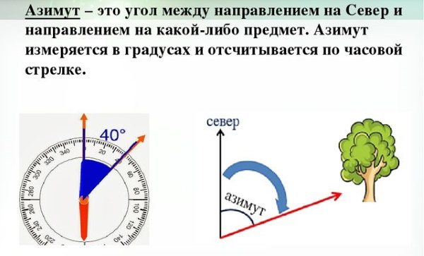
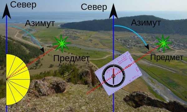
Azimuth (Az) is the angle between the directions to the north and to the object, measured clockwise, by analogy with the movement of the sun on the horizon. The apex of this angle can be an observer holding a compass. One usually learns to use a compass by measuring the bearing to a visible target.
In reality, before starting to follow the compass needle, the traveler should measure the azimuth on the map and calculate the azimuth on the ground, taking into account the corrections. The clarifications are related to the Earth's magnetic field and its change over time. In a compass, the direction north is indicated by a blue or marked arrow.
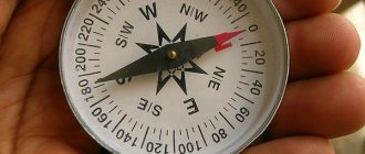
This is 0° or 360° on the scale. The direction to the east has an azimuth of 90°, to the south - 180°, to the west - 270°.
Finding magnetic azimuth
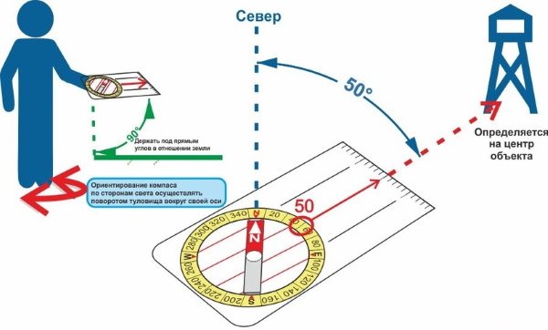
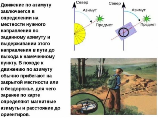
You need to learn how to determine magnetic azimuth if you need to determine the direction of movement relative to any object. This is because the magnetic azimuth is the angle between a certain route point and the north direction (Figure 6).
The magnetic azimuth can be determined in the following way:
- First of all, you need to stand so that you are in the direction of the selected object.
- The compass should be placed on a flat surface no higher than chest level. Alternatively, you can simply hold the device in front of you on your outstretched palm.
- Next, you need to orient the compass by aligning its blue arrow with the letter C.
- A thin stick or match should be placed in the center of the compass. The end of this stick should be directed towards the designated point.
- Next, they begin to slowly turn the stick clockwise, but without allowing it to move from the center. Under the final value, on the dial, you can see the desired digital value.
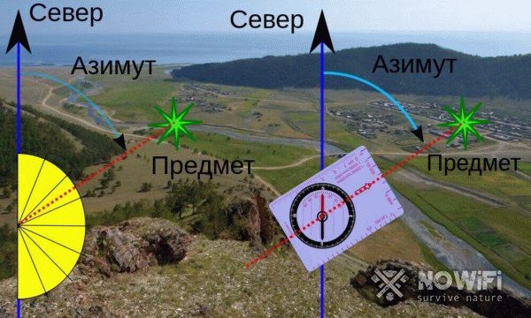
Figure 6. Determination of magnetic azimuth on the ground
If necessary, the magnetic azimuth can be determined not only for an individual object, but also for the entire 360-degree circumference of the area.
Why is azimuth needed?
It is necessary to be able to determine your location on the road for such professions as rescuers, sailors, and military personnel.
This skill should especially be honed among tourists traveling on their own. Without understanding what azimuth is and how to use a compass, it is impossible to correctly plot a route.
In what units is azimuth measured?
Since azimuth is an angle, it is measured in degrees. A degree is 1/360 of a circle. The round compass scale covers 360°. 1 degree contains 60 minutes (60′). 1 minute consists of 60 seconds (60″).
In professional orienteering instruments, a second scale is installed, showing the dimensions of the angle in radians. 1°=π/180°≈3.14/180°≈0.017 radians. Such fine scale divisions are impossible on small pocket instruments. That's why radians are used by professionals. The division of a tourist compass is most often 2°-5°.
Types of azimuth
Azimuth happens:
- true (geographic);
- magnetic.
Geographic azimuth is a mathematical angle that is measured from the northern direction of the meridian to the line on the map directed to the desired object. It is more convenient to measure geographic azimuth, especially in hiking conditions, with a protractor. The base of the instrument is aligned with the vertical.
The count is made along the arc of the protractor to the point of intersection with the line directed at the selected object. True azimuth can be forward or reverse. The difference between them is 180°. Thanks to reverse azimuth, you can return along an already traveled route, since it points in the opposite direction to the original one.
Geographic azimuth is used to plot routes in preparation for a hike or expedition.

Magnetic azimuth is a horizontal angle measured on the ground from the north pointer to the direction of the object of interest. To use approximate angles in real life, after measuring on a map, geographic azimuths are converted to magnetic ones. Experienced travelers do not go on a hike without measuring the emergency azimuth.
On the road, you can deviate greatly from the route for various reasons. Therefore, a reference point for the object is selected, near which all the data will be clarified. It is good to choose a road, a settlement, or a river as such a landmark. A part of a linear object is selected that stretches for many kilometers in a relatively straight line, without making sharp turns.
For traveling a distance of several kilometers, this is undoubtedly a life-saving option. If we are talking about tens and hundreds of kilometers in deserted areas, then the choice of emergency orientation objects must be approached with particular seriousness.
What is emergency azimuth
Emergency azimuth is used in an emergency situation.
In an unfamiliar area, you can easily deviate from the chosen route and lose your bearings. In cloudy weather, at dusk, it is generally impossible to understand where west and east are. In this situation, an emergency azimuth will help you return home. It needs to be determined in advance.
Emergency azimuth is the direction to a large extended object that is impossible to pass by. It could be a river, a seashore, a highway, a railroad, a power line, or a big city.
The emergency azimuth is taken as follows:
- They enter the forest ten meters along a line perpendicular to an extended object (for example, a road) and turn to face it.
- Take a compass, align the north arrow with the zero, and mentally draw a line perpendicular to the road (or use a sight).
- At the intersection of the perpendicular with the scale there will be an azimuth value. It needs to be written down without relying on memory.
- Place the spare tire in your pocket so that it cannot be lost. An emergency azimuth will help you return if there are no landmarks, even in a snowstorm and fog.
The object to which the emergency azimuth is taken must be large and extensive. You can walk past a small village, a small lake, a tower, without noticing them.
The Internet and cellular communications outside the populated area disappear at the most inopportune moment. It is enough to move away from the road or power line, to be outside the coverage area of cellular towers, and the phone becomes useless.
The ability to read a map and calculate azimuth will help you easily find your way home. Therefore, survival experts recommend always having a compass with you.
Determining azimuth using a compass
The compass is a medieval invention that has stood the test of time. It is the easiest way to measure azimuth using it. To do this, turn the compass horizontally until the north side of the arrow points to 0° on the instrument scale. Looking at the target through the slit, direct the drawn arrow or line along the line connecting the eye to the observed object.
Counting the scale from the zero position to the mark or arrow on the body, located on the line of sight, gives the value of the magnetic azimuth of the visible object. It is impossible to determine azimuth using a compass in areas of magnetic anomalies and poles.
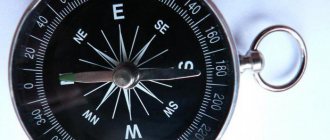
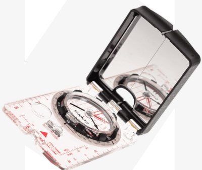
Which compass is suitable?
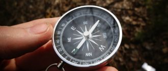
The value of a compass lies in the fact that its needle always points in the same direction, from which you can count. Therefore, any compass is suitable for orientation purposes.

The compass is:
- ordinary;
- lensed;
- tablet;
- mirror;
- electronic.
An ordinary compass consists of a bulb, a needle and a dial (a rotating dial). The lensed compass is most often used in weapons for aimed shooting, in geology and geodesy. There are models with radioactive backlighting, which last for years without requiring either charging or external light sources.
Components of a lensed compass:
- ordinary compass;
- cover with a slot for sighting;
- lens and a slot at the top of its holder.
By aligning the fishing line stretched along the slot of the cover with the direction of the gaze through the slot above the lens to the landmark, the observer through the lens also sees an enlarged marking on the compass dial. Thanks to this sighting device, the readings taken are highly accurate. Often such compasses have a much smaller radian scale.
The lensed compass is bulky and heavy. All its capabilities are used only by specialists.
A tablet compass is convenient for working with a map and for determining the angle on the ground. The transparent base and parallel lines on it allow you to accurately align the compass with the map grid and quickly measure true azimuths. Additionally, on the transparent plate there is 1 regular ruler and 2 scaled ones (most often 1:25000 and 1:50000). The scale is in degrees.
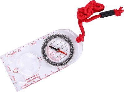
2 wide stripes on the dial make it easy to follow the desired direction. An arrow on a transparent base facilitates quick reading of azimuth in natural conditions. In terms of speed of learning, task completion, light weight and compact size, the tablet compass is superior to other types.
All over the world it is very popular among tourists, young people involved in orienteering, tourism, and paramilitary games. The mirror compass gets its name from the mirror placed under the protection of the cover. The cover has either a hole or a mark at the top center for sighting an object aligned with the front sight on a transparent base.
On the same basis there are a simple ruler, rulers with popular scales, and parallel lines for working with a map. The scale is marked in degrees. There are two wide stripes at the edge of the dial to help maintain the direction of movement. Some models have magnifying lenses for recognizing small symbols on the map.
Other models do not have a transparent base for working with the card. The mirror performs the same function as the lens in a lensed compass: it allows the observer to simultaneously aim the line of sight at an object and see the instrument scale.
Thanks to the sighting device, a mirror compass gives more accurate readings than a tablet one, but in most cases, moving through human-developed and limited territories, a relatively cheap and simple tablet compass is quite enough.
The electronic compass has a different operating principle. The compass app can be downloaded to your smartphone. On its screen, under the coordinate plane, the azimuth value is displayed in numerical form. The program converts the data received from the satellite (true azimuth) into magnetic data.
For a tourist, such an independent compass is just a godsend, but it comes down to the fact that the smartphone requires electrical power. The satellite signal cannot be detected indoors, underground, or in caves. This compass can be used in games and weekend routes. The table provides examples of orientation programs.
| Smartphone OS | Application Name |
| Android | Compass 360 |
| Smart Compass | |
| Accurate compass | |
| iOS | HD Compass |
| Gyro Compass | |
| Commander Compass Go |
Mechanical compasses should not be stored close to metal objects or objects surrounded by an electromagnetic field, such as electrical appliances.
These factors not only lead to breakdown of the compass, but also cause uncontrollable errors on a working device if readings are taken from it near a vehicle, a power line, or with a cast-iron pot over one's shoulders.
If the compass breaks down, it becomes necessary to make a homemade one. A light iron object is suitable as an arrow. Traditionally, this is a needle that even a novice tourist takes on a hike. To ensure minimal friction interferes with the movement of the needle, it is placed on water poured into a plastic container or polyethylene. The needle will not sink if it is stuck into a piece of cork or light waterproof synthetic material.
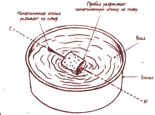
A dry small needle can be carefully placed directly on the water. The water must be clean so that microorganisms or debris do not affect the position of the arrow. Before placing the arrow in the water, it is magnetized by friction with the hair.
They protect themselves from the wind with their own body. It is advisable to find additional natural shelter. Which end of the needle points north is determined by the sun or the North Star.
How to hold the device correctly?
It is possible to determine azimuth using a compass if you know how to use it. Since devices with a sighting device seem more complex, it is wise to consider ways to work with a compass on them.
Basic techniques for positioning the compass when determining azimuth:
- central grip technique;
- compass to cheek.
Central grip technique step by step:
- Install the cover with the slot and the fishing line perpendicular to the base.
- Deflect the lens with the slot at least 45° from the magnetic compass.
- Turn your face towards the selected object.
- Grasp the device with your thumbs and forefingers from the sides. The compass will rest on the intertwined remaining fingers.
- With your elbows apart, as if putting on a diving mask, bring the slit above the lens to your eye.

A reminder on how to correctly determine azimuth using a compass.
Compass-to-cheek technique:
- Open the cover with the sight, leaving it in an upright position.
- Install the lens at an angle to the dial.
- Use the index finger and thumb of your right hand (if you are right-handed) to hold the compass. The left palm supports the right, clasping its free fingers.
- Bring the compass to your eye, placing your hand on your cheek.
How to get the right direction?
You need to determine the azimuth using a compass while in one of the positions described above.
This requires:
- Align the line on the cover with the guide.
- Look through the lens at the dial and set the north hand to the zero position.
- Find a stationary aiming line and read the numerical value under it.
Compass readings must be double-checked to avoid possible errors. In any weather and time of day, as long as the arrow pointing north is at 0°, movement in a straight line, continuing the aiming line, will lead to the chosen target.
How to find azimuth - 3 ways
There are different ways to find azimuth. It can be determined using a protractor, topographic map and compass.
1️⃣ Using a protractor
To determine azimuth from a map, you need to have a ruler and a protractor. On all paper and electronic maps, north is at the top. Therefore, south is at the bottom, east is on the right, west is on the left.
Azimuth is determined as follows:
- Find an observer's point on the map and mark it with a pencil.
- A straight line is drawn through the observer’s point (from bottom to top, perpendicular to the top (or bottom) edge of the map. This is the north-south direction.
- Find another point (object) to which you need to take azimuth.
- Connect the observer's point and the object with a straight line.
- Place the protractor along the north-south line.
- Align the observer's point with the center of the protractor.
- Read the value at the intersection of the protractor scale and the straight line connecting the standing point to the object. This is the true azimuth value.
- By adding (or subtracting) the magnetic declination, you get the magnetic azimuth.
If very accurate measurements are needed, a correction for the convergence of meridians is taken into account.
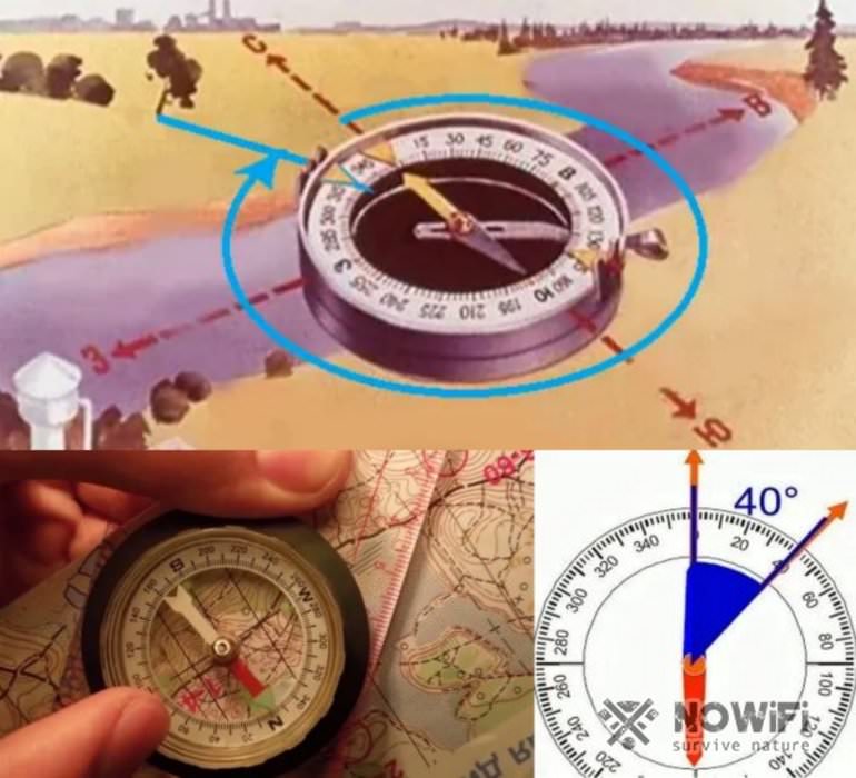
2️⃣ Using a tablet compass
The tablet compass consists of a plastic box (flask), which contains a magnetic needle on the axis, and a graduated scale. The flask is fixed on a transparent platform with markings - a tablet. To make it easier to read the map, it has a built-in magnifying glass (not available on all models).
To find direct azimuth, you need:
- Place a compass on the map.
- Align the edge of the tablet with the route line (or point the large central arrow in the direction of the object).
- Rotate the compass bulb so that the parallel red lines on its bottom become parallel to the compass needle and the lines of longitude on the map.
- At the point of intersection of the axial arrow on the tablet and the compass scale, we read the value of the directional angle. It can be converted to magnetic or true azimuth.
Tablet compasses come in regular and liquid compasses, in which the box (flask) with a magnetic needle is filled with non-freezing liquid. The viscous medium helps the compass quickly stabilize after running and sudden movements.
3️⃣ Using a compass and map
Any compass is suitable for determining azimuth from an oriented map.
To do this you need:
- Find a standing point on the map and mark it.
- Find the object to which you need to take azimuth.
- Draw a line to the north through the standing point (from bottom to top, perpendicular to the edge of the map).
- Connect this point with the object to which you want to take the azimuth with a straight line.
- Place the compass on the map.
- Orient the map relative to the cardinal points: align the north arrow with the lines of longitude (to do this, rotate the map until the arrow and lines of longitude coincide).
- Move the center of the compass to the point-object line.
- Read the azimuth value at the intersection of this line and the scale.
This is interesting: How to behave if you find yourself on a sinking ship
This method provides complete information about the location and course of travel.
If the area is open, you can see objects both on the map and in the landscape, which will help you orient yourself correctly and calculate the mileage and duration of transitions.
How to determine azimuth on the ground?
The meridians on the map converge at the geographic pole, located on the Earth's axis of rotation. To determine azimuth in natural conditions, a magnetic compass is used, oriented towards a magnetic pole different from the geographic one. Therefore, the measurements on the map need to be adapted for practical application on the ground.
The angle between the magnetic and true meridians is called magnetic declination. It is by this value that the true and magnetic azimuths differ. If the magnetic meridian passing through the observation point is east of the true one, then the declination is called eastern (+), to the west - western (-). Each locality has its own declination.
Am = Au - δ, where δ is the eastern declination. Am=Au+ δ for western declination.
Magnetic declination is given in topological and marine navigation charts. It is not always indicated for tourists. Before going on a hike, be sure to find information about magnetic declination. It can have values of tens of degrees.
This is a huge error even for short routes. In addition, every year the Earth's magnetic field changes by 0-0.2°. Using new maps, this value can be neglected.
How to determine azimuth from the coordinates of two points?
The coordinates of a point on the map are latitude and longitude. Latitude is the angle between the equatorial plane and the zenith direction (perpendicular to the earth's surface drawn from the point of interest). Latitude values range from 0° to 90°. In the northern hemisphere they are considered positive, and in the southern hemisphere they are considered negative.
Longitude is the angle between the plane of the Greenwich meridian and the plane of the meridian passing through the defined point. Its values are 0° to 180°. Longitudes located east of Greenwich are considered positive, and those located to the west are considered negative.
Coordinates are expressed in degrees, minutes and seconds or in decimal fractions of a degree. The letters N, S, E, W indicate in which hemisphere the point is located. If the coordinates of two points are known, find their position on the map. The first coordinate (latitude) is laid out along the parallel, the second (longitude) - along the meridian.
Next, a straight line is drawn through the points until it intersects with the meridian closest to the left. The angle between them is measured from left to right. This is the azimuth of the direction given by two known points.
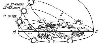
How to determine azimuth from the sun?
According to astronomical time, the sun points south at noon. But Russia lives on maternity time, with a 1 hour shift from standard time. Therefore, you need to make adjustments for summer and winter time. Since the shift in other years can be announced by 2 hours, it will be assumed here that at 12 noon the Sun is in the direction due south.
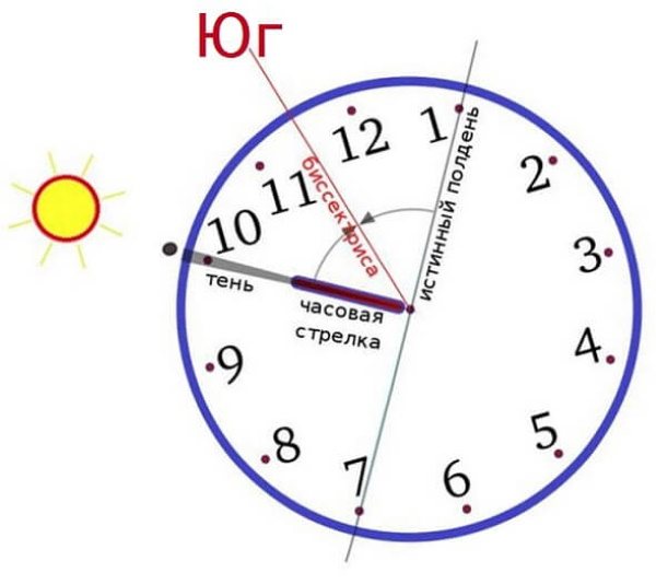
To determine the azimuth by the sun you need to have a watch. At noon, the direction north is marked on the dial. The sun moves along the southern side of the celestial sphere, so at other times of the day the direction to the south is also determined.
This is done like this:
- The clock is installed horizontally.
- The hour hand is pointed at the solar disk.
- The angle formed by the hour hand with the number 12 on the dial is divided in half. The bisector drawn through the division point shows the direction to the south.
Having a north direction, the azimuth to the desired object is measured in the usual way. Knowing that the hour division on an arc of a circle corresponds to 30°, you can turn your watch into a compass.
If one azimuth is enough to achieve the goal, then they limit themselves to its mark on the dial. You just need to maintain a certain direction of the cardinal points without changing the position of the clock. Reorientate as often as possible, every hour or two.
Calculation of the value by the sun
If you don’t have a map, protractor and compass at hand, you can determine the azimuth by the sun. To do this, you will need a mechanical watch dial and a clearly visible celestial body. You can find the azimuth as follows:

- The watch must be placed on a flat surface and the hour hand pointed towards the sun.
- Draw a line from the center of the dial and divide the resulting angle in half.
- The angle vector indicates the direction strictly from north to south.
- Up to 12 o'clock, when north is to the left of the arrow, the azimuth is determined by counting the value counterclockwise.
- In the afternoon, when north is already to the right of the drawn line, the azimuth can be measured clockwise.
Having completed all the calculations, you can begin planning your movement around the area. Since insurmountable obstacles often arise along the route, you need to know how to determine and maintain a route without a compass and map. With this movement, you can focus on noticeable objects on the ground.
The travel planning is as follows:
- Choose a noticeable landmark located on the opposite side of the obstacle. Ideally, such a mark should be on the line of movement.
- Determine the azimuth to bypass the existing obstacle. You will need to take several measurements, including using the sun or using a map and compass.
- An obstacle is overcome, after which pre-selected landmarks are found on the ground and a new direction is laid from them strictly according to the calculated position.
If there is no clear guideline for making calculations, you can easily do it yourself. A notch made in a tree or a large stick stuck into the ground, visible from afar, will do. However, in cases where an obstacle with zero visibility is overcome, for example, it may be a high mountain slope, it is impossible to select a starting point for calculations, and you will have to navigate solely using a map and compass.
What is the difference between azimuth and heading angle?
Coordinate grids are applied to the maps. Usually this grid is formed by meridians and parallels. On topographic, that is, large-scale maps, the page depicts the area within such a cell. For the convenience of laying routes and linking objects together, a rectangular coordinate grid is applied to the sheet, oriented to the cardinal points.
The grid lines are parallel and perpendicular to the axial meridian of the zone (the globe covers 60 zones of 6° each). Towards the boundaries of the zone, the meridians bend more and more due to the ellipsoidal shape of the earth's surface.
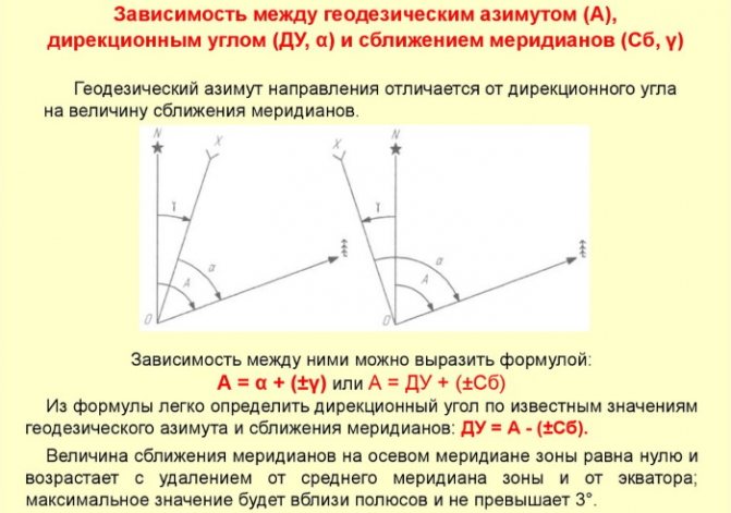
The angle between the north direction of the true meridian drawn through the point in question and the vertical line of the rectangular grid is called the convergence of the meridians. Points located to the right of the northern direction of the zone's middle meridian have a positive convergence value; those on the left are negative.
True azimuth is the angle between the true meridian (north direction) and the direction to the object. Directional angle – the angle between the north-oriented rectangular grid line and the direction to the selected point.
Both directional angle and azimuth are measured clockwise and take values from 0° to 360°. a=Ay or A=a+y, where A is the true azimuth, a is the directional angle, y is the convergence of the meridians.
The concept of azimuth and its types
In general, azimuth is the angle between the north-south direction and a straight line drawn through the standing point and a reference object (on the ground or on the map).
From Arabic, this term literally translates as “direction.” Azimuth is measured in the range from 0 to 360°, the count is taken clockwise.
There are magnetic, true (geographical), geodetic, gyroscopic, and astronomical azimuths.
Magnetic azimuth is the horizontal angle between the magnetic field lines connecting the Earth's north and south magnetic poles and the direction towards an object. The compass needle is always oriented along the lines of the planet's magnetic field and points one end to the north and the other to the south. The northern end is aligned with zero degree on the compass scale.
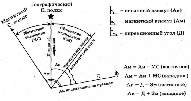
Geographic azimuth is the horizontal angle between the geographic meridian at the standing point and the direction to the landmark. It differs from the magnetic one in the magnitude of the magnetic declination, caused by the mismatch of the true and magnetic poles.
Geographic meridians and parallels do not coincide with the lines of the coordinate grid by several degrees, therefore, when making accurate measurements, a correction is made for the convergence of the meridians. Magnetic declination and convergence of meridians are indicated at the bottom of the topobase, outside the sheet.
Gyroscopic azimuth is the angle between a conventional line running from south to north through the gyrocompass and a given direction. There are small discrepancies between gyroscopic and geographic and magnetic azimuths, since the gyroscope takes into account the correction for the rotation of the Earth (gyrocompass delta).
Astronomical azimuth
Astronomical azimuth is a 2-sided angle between the plane of the astronomical meridian and the vertical plane of a given direction. The countdown is taken from the north (clockwise).
Geodetic azimuth is a 2-sided angle between the geodetic meridian plane and the tangent plane that passes through the standing point and the observation point.
In geodesy, it is taken into account that the Earth is not a perfect sphere; the planet is “flattened” at the poles and is an ellipsoid of rotation. Therefore, the standing point-observation point plane contains the normal to the ellipsoid.
In geology, the azimuths of dip and strike of rock layers and fractures are measured. Measurements are taken to construct geological maps of mineral deposits on the surface and in volume.
To navigate the terrain, it is enough to understand the difference between magnetic and geographic azimuths. In addition, it is important to know the magnetic declination in a particular area.
The Earth's magnetic poles are gradually moving. The further north (or south) the area, the greater the magnetic declination. In the southern hemisphere, the magnetic pole is located in the ocean, near the coast of Antarctica. In the north - on the territory of the archipelago belonging to Canada.
Orientation in the forest according to the cardinal directions without a map
Determining azimuth using a compass is especially important in places with poor visibility. It is better to go through the forest with a compass, watch, notepad and pencil. Immediately draw the beginning of the route and marking the cardinal directions. The compass allows you to mark the angle of change of direction at each turn. At each turning point, it is recommended to record the number of steps taken and the time during which this section of the path was completed.
It is convenient to count your steps using a tracker by entering your step size into it. Moreover, it can withstand at least a week without recharging. With such records, you can return the same way or simplify it with a guarantee of minimal loss of time.
This method is incomparably more reliable than studying mosses on trees or observing herbs. Plants are also affected by factors other than cardinal directions. You can apply the above described method of orientation using a watch.
Rules for moving in azimuth with obstacles
If there are obstacles along the route, it may be necessary to adjust the planned actions on the spot. If you need to cross a river or ravine, select a noticeable object on the opposite side in the direction of the calculated azimuth. After crossing, check the correct direction.
In case of poor visibility or a high obstacle, before starting to go around it, leave a mark on the terrain: a notch, a bright ribbon, a pile of stones. It is recommended to make it a rule to bypass obstacles alternately from the left and then from the right in order to neutralize increasing errors in the direction of movement. They choose the azimuth of the detour, trying to bypass it so that it does not change again until the middle of the path.
They move in straight lines and count their steps, recording azimuths and distances traveled. They return to the planned direction, walking the same number of steps on the other side of the obstacle. The following angle along the second part of the detour is calculated according to the isosceles triangle rule: 180°-2A, where A is the angle of deviation from the route at the beginning of the detour.
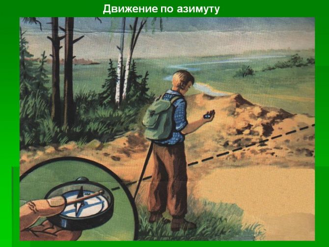
What is azimuth? This is an angle measured clockwise from the direction north to the direction towards a given object (landmark). Azimuth is measured in degrees from 0 to 360. If the geographic meridian is taken as the initial direction, the azimuth is called true; if the magnetic meridian is taken as the initial direction, the azimuth is called magnetic. Movement in azimuth consists of determining the desired direction on the ground at a given azimuth and maintaining this direction along the way until reaching the intended point. During a hike, movement in azimuth is usually resorted to in closed areas or off-road, for which magnetic azimuths and distances to landmarks are determined in advance using a map.
Movement using intermediate landmarks. When moving in azimuth, the practical accuracy of reaching a landmark is usually up to one tenth of the route traveled. Therefore, it is always advisable to mark intermediate landmarks along the route. To do this, before moving, set the compass sighting device to the desired direction and orient the compass. Then they sight in the desired direction (or near it) some clearly defined and not very distant landmark, towards which they move. Having reached the landmark, the operation is repeated again. When determining the direction, you must ensure that the northern end of the compass needle coincides with the north mark on its dial. When moving in azimuth, tourists may encounter significant obstacles along their path, such as a lake or a rocky area. To strictly maintain the general direction, it is advisable to go around them along a broken straight line with the least number of “elbows”. When walking around, you should clearly record the values of intermediate azimuths and the distances traveled along them. In order not to stray from the right direction, it is useful to draw on a piece of notebook paper (on a tablet) while moving, a detour path with angles and lengths of “knees”.
Movement without clear landmarks In the field, tundra, steppe, where there are no landmarks, or in poor visibility, you can move using the alignment method. The tourist leading the movement controls the direction, being at the end of the group: he sees the entire chain of tourists, can compare its direction with a given azimuth and promptly warn about deviations. If there is a sun (moon, stars), you can move in azimuth by measuring the angle of direction relative to these celestial bodies. Every half hour their position in the sky must be clarified using a compass. Of the techniques for such orientation, the most common is orientation by one's shadow. In windy weather, it is useful to remember the direction of the wind or the movement of clouds relative to the sides of the horizon. In wide open spaces in winter, snow sastrugi can be used to guide movement. In a densely forested area, in order to maintain direction, it is recommended to alternately bypass the encountered obstacles - trees, bushes, rubble - either from the left or from the right. Sometimes, in the absence of intermediate landmarks, it is useful to make a deliberate deviation in a certain direction from a given azimuth. Having covered the distance calculated in steps or according to the time of movement to the final landmark, tourists turn sharply to the side and look in a new direction (one, and not in two opposite ones, as would be the case if they were moving straight along a given azimuth) for the desired point on the ground. For large distances, it is necessary to mark out limiting (lateral) landmarks, and choose the final landmark as linear as possible and such that it is deployed with a wide front towards the direction of movement of tourists.
When you lose your orientation. On an easy section, you can continue moving forward as a group until you reach a known place. You can’t do this on a difficult section of the route: here it’s better to spend time on thorough reconnaissance than to go blindly. If tourists get lost and reconnaissance does not give hope of finding their way correctly, then in the absence of roads they need to go out onto the “water” and walk along it downstream: a stream will lead to a river, that will lead to a large river, on which tourists will definitely meet a person, housing will receive the help they need. Along the way, you should leave notes with notes in visible places - this will make it easier and faster to find the missing.
Errors and their causes
The main causes of errors when moving along the route:
- on the ground they use true azimuth;
- do not pay attention to the factors that force the compass needle to deviate from the north direction;
- do not check the compass for serviceability;
- inattentively follow the direction of movement.
The first reason arises if a tourist took readings from the map, but is not aware of the existence of magnetic declination. As already mentioned, in places where there are objects that create electromagnetic fields, where there are large accumulations of iron, the compass needle is temporarily strayed from the correct course. Magnetic anomalies of natural origin are quite rare.
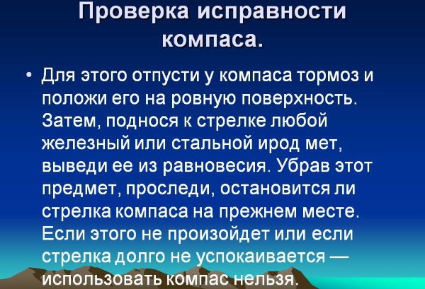
To check the compass for serviceability, bring a magnet or iron object to it. After it is removed and the arrow has stabilized, the iron is brought in from the other side. If the arrow returns to its previous position, then everything is in order.
When moving in azimuth you must:
- develop an accurate algorithm for following straight lines (selecting distant visible landmarks) and using a compass;
- check the correct orientation more often;
- try to check with linear objects (road, river).
The ability to find azimuth using a compass improves with each trip. Already on the second route, gross mistakes are usually not made.
Author: Svetlana Bulgakova
Practical execution of movement along azimuths during the day
At the beginning of the movement, we determine the azimuth with a compass to orient the path. You need to choose some kind of landmark, it can be either natural or built by man, the main thing is that it is very bright so that it can be seen from all points. Having reached it, we re-select a landmark and move on. Compare your location with a map.
Features of terrain orientation in conditions of limited visibility
Orientation in conditions of limited visibility, although similar to night orientation, is still different. Poor visibility, i.e. snow, fog, smoke, rain, sharply reduces access to landmarks. If at night you can use flashlights, spotlights and other devices to increase visibility, then this will not help.
During this period, you should look at the map more often and mark your path with lines on it. Predict in advance all the outcomes of your journey and weather conditions. Choose such and such small landmarks in order to rely on something.
When it suddenly starts to rain, fog, or snow, you need to stop and write your route on the map. To follow it as accurately as possible. Indeed, during conditions with poor visibility, landmarks may simply not be visible. Therefore, along the way, leave some marks on the trees. Watch your path.
Azimuth orientation
Orientation at night
In order not to lose the right direction at night, you need to take proper care of this during the day. You need to mark on the map the necessary places and landmarks so that you can easily navigate them at night. You need to take flashlights and spotlights with you to see the way. You can also take reference points to large factories, towers, towers, they are illuminated at any time, colors emanate from them.
Orienteering in the forest
So, in the forest it’s quite bad to choose landmarks. Since there is a dense area of droppings and trees. But still, in order to correctly navigate the forest, you first need to turn to the map. Use it to write down some important places that you should navigate. At night, you should navigate by the Sun or constellations. You can also navigate using the moon. Internal indicators should not be ignored either. Tree bark, anthills, stumps will help you determine the cardinal directions.
We recommend reading:
Behavior in an emergency
Orientation in large populated areas
Navigating in a large area is quite difficult, because there are many distractions and not such an open view. When entering the city, you need to mark your location and, moving around the city, monitor and mark your movement on the map.

Compass
Orientation in areas of destruction
Navigating in such places is very difficult. After all, the data on the map and the data in reality are strictly different. And no one knows where and when a new collapse, fire, devastation will occur. At such a moment, you should focus on nature. Follow the path along rivers, lakes, springs, prominent slopes; these landmarks are difficult to break. You also need to read a topographic map fluently. This will help when moving. You should also, while walking the trail, mark on the map the difference between the map and reality.
Orientation in winter
In winter, orientation becomes more difficult, because snow covers all natural signs. To find the right way, you need to look at bridges, roads, trails that have already been laid by someone. You should also watch the Big Towers; they are especially visible at night. If you get lost in the forest, you can read tips on how to escape the cold in winter on our website.
Compliance with standards
To practice skills, there are training tasks. Their execution time increases by 25%. The results of the training are also assessed. An “excellent” grade is given if more than 90% of the tasks completed received a good grade and at least 50% received an “excellent” grade. “Good” is given if 80% of the tasks are completed and 50% receive a grade of good or higher. “Satisfactory” is given if 70% are rated positively and at least three standards are rated “good.” And “unsatisfactory” is given if the conditions of the previous assessment are not met.
So, in this article you learned how to navigate by azimuth simply under different environmental conditions. We wish you pleasant travels and a great holiday!
Author of the publication
offline 2 years
Nika
7
I am interested in hiking and traveling, photography and videography. I have been going hiking since childhood. The whole family went and went - sometimes to the sea, then to the river, to the lake, to the forest. There was a time when we spent a whole month in the forest. We lived in tents and cooked over fires. This is probably why I am still drawn to the forest and, in general, to nature. I travel regularly. About three trips a year for 10-15 days and many 2 and 3 day hikes.
Comments: 0Publications: 668Registration: 10/23/2018
Nika Survival in the wild, Orienteering, Articles