Category: Astronomy for Dummies Published 01/20/2019 · Comments: 0 · Reading time: 5 min · Views: Post Views: 19,015
Where is the North Star ? This is perhaps one of the most popular questions for beginners. Indeed, for those who are just beginning to study the starry sky, the North Star plays an important role, being the starting point for celestial orientation. Let's see together how to find the North Star in the sky!
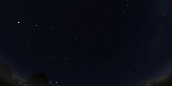
Polaris in the sky
It can easily be found in the sky in the late evening or at night. One condition: the night must be clear and cloudless.
The earth and other celestial bodies are constantly moving. Many people ask how to find the North Star and “catch” it when everything in the world is in endless motion. Northern Hemisphere travelers can rest easy. It is the northern star that always remains in the same position relative to a person. With its help you can accurately navigate in space.
Experienced travelers who have been guided by the North Star for a long time know that it always stays in a northerly direction. Its deviation from the trajectory of movement is minimal: the error is only 1.5 degrees. This indicator is important for navigation, but not for a lost traveler, so such orientation in space will be unmistakable.
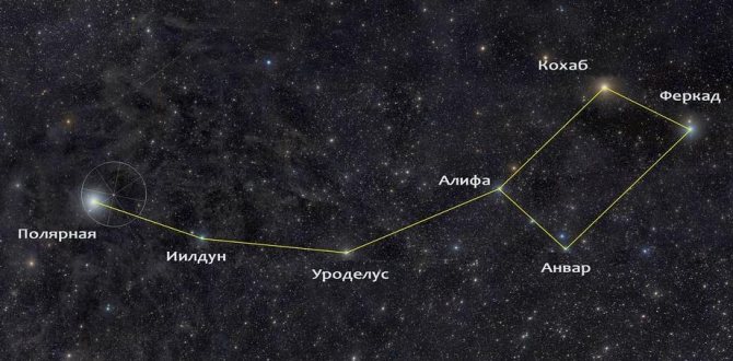
Before you can determine where the bright guiding light is, you need to learn how to “read” the night sky a little. Finding the North Star is easy if you understand where the constellation Ursa Major (or the “big dipper”, as people say) is located.
The Big Dipper is formed from 7 stars, which are shaped like a huge ladle with a handle. “Kovshik” is always visible in all regions of Russia, with the exception of autumn in the south. There, in the autumn, the Big Dipper hides behind the horizon.
The Polar Star itself shines in the “tail” of another “dipper” - Ursa Minor. We need a large “bucket” so as not to confuse it with other stars: many of them look much larger and brighter than Polaris, and it can easily be confused with them. In addition, a large “bear” is more noticeable in the sky than a small “bucket”.

So, we found the Big Dipper in the sky. Now, focusing on it, it will not be difficult for us to understand how to find the North Star:
- we find the two outermost stars of the “big bucket” (this is its “wall” facing outward);
- mentally draw a line from them straight up (it should be equal to approximately five distances between these stars);
- “we meet” the tail of the Ursa Minor dipper, the polar star is the end of its “tail”.
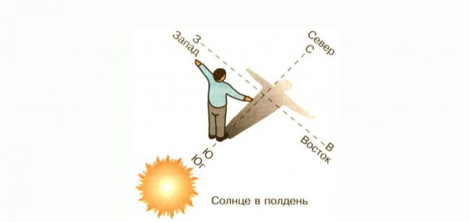
North direction found. Now it remains to determine the sides of the horizon. You need to turn your face to the north and place your arms in different directions. West will be on your left, east will be on your right, and south will be directly behind you. This method is applicable in our northern hemisphere.
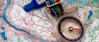
How is true azimuth determined on a map?
In the previous section we described how magnetic azimuth is determined. It is called magnetic because the compass needle actually points not to north, but to the Earth's magnetic pole.
If you navigate not by the map, but by the azimuth measured in field conditions, then the measurement described above is quite sufficient. However, when using the card, another computational operation will be required.
The fact is that on the map, azimuth is measured as the angle between the meridian passing through the point (the vertex of the angle) and the object. But... the meridian is directed to the North Pole, which does not coincide with the magnetic one, therefore the azimuth on the map and the azimuth on the ground will not coincide by the amount by which the true and magnetic meridians do not coincide.
This difference is called magnetic declination. When the magnetic needle deviates to the east, the magnetic declination is eastern (indicated by “+”), to the west – western (indicated by “-”). There are no constant indicators for magnetic declination. So, in the Moscow region it is +7... +8°, in the Irkutsk region it is close to zero, in other regions it can differ quite significantly.
To convert the true azimuth, determined from the map, into magnetic, determined on the ground, you need:
— determine the true azimuth from the map;
- find this azimuth on the ground;
— if the magnetic declination is eastern, then shift the direction line to the left of the one found by a number of degrees equal to the declination;
— if the magnetic declination is western, then shift the direction line to the right of the one found by a number of degrees equal to the declination.
The magnitude of magnetic declination is usually indicated on the map - outside the frame, at the bottom. If the magnetic declination is not indicated on your map, you must find it out before setting off, otherwise, in an unfamiliar area or at sea, a compass and maps will be useless.
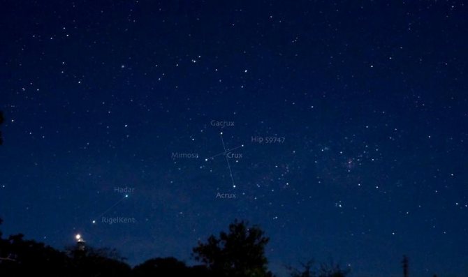
Southern Cross: Landmark in the Southern Hemisphere
People who live in the southern hemisphere are guided by a different constellation. It is called the Southern Cross, and in our latitudes you will not be able to see it. It looks like four stars arranged crosswise. Conventionally, “nearby” there is a constellation similar to it - the False Cross. It differs from the South by the location of the luminaries more distant from each other.
You should focus on the southern direction. A line is mentally drawn along the stars that form the vertical “crossbar” of the figure. To avoid mistakes, it is better to wait until the moment when the constellation “stands” completely vertical in the sky. It will be located perpendicular to the horizon, therefore, south is directly under the Southern Cross.
Studying
Screenshot from the planetarium program
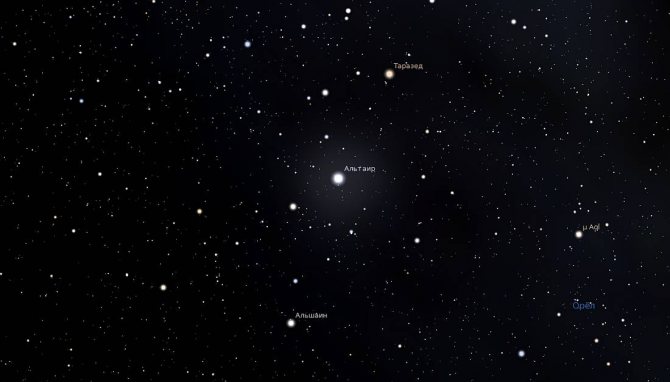
Gerard van Belle and his colleagues in 1999 and 2000 investigated and suggested that Altair, due to its rapid rotation, has a surface gravity and a temperature at the equator lower than it should be. The star's equator is less bright, which is called gravitational dimming. Dominicano de Souza conducted a study in 2005 and measured gravitational darkening using the VINCI instruments on the VLT. Altair is one of a small number of luminaries from which it was possible to obtain images of their disks. Similarly, like the effect of surface compression, one can see the gravitational darkening of Altair without straining.
Comparison of stellar surface models with real photographs
To see the surface of this object in more detail, you need a telescope with a mirror diameter of 300 meters. But today this is an unattainable parameter. Despite this, astronomers managed to see and study the star using several telescopes.
Similar articles
Orientation to the Sun
The correct path using the stars is found at night, provided the sky is clear. During the day and in the morning, the Sun will help you get on the right road. How to navigate by the Sun? This will require minimal geographical and topographic knowledge.
The sun always rises in the east and sets in the west. The shadow of the Sun at noon points west.
It is convenient not only to find the way. If it happens that you do not have a watch with you or it is lost, using the Sun it is always possible to determine the time of day. It is necessary to install a pole or stick in the ground in a vertical direction. A pattern is drawn around it like a watch dial. Now you need to observe the movement of the shadow from the pole along the drawn dial. This way the approximate time is determined. Interestingly, the maximum error in this case is no more than 10%.
How is magnetic azimuth determined on the ground?
On a specific area of land or water, the azimuth is measured from the magnetic meridian. To do this, you need to position it in such a way that 0° and the letter “C” are located in the north - the magnetic needle will point there.
As soon as the north is found, rotate the sighting device so that its front sight and the object specified for movement, whose azimuth you are determining, coincide. During rotation, you must strictly ensure that the magnetic needle does not move away from 0°. When all the actions are completed, they look at how many degrees the pointer is at - they will be the azimuth - angle - of the given object.
When the compass is not equipped with a sighting device, an ordinary thin stick is used instead. First, the compass is oriented in the same way as described above, and then a stick/straw/match is placed on it. It should cross the center of the dial, and one end of it should be strictly directed towards the object. At how many degrees the end of the stick lies, this is the azimuth.
How to navigate by the Moon
In addition to the North Star, there is also a satellite of the Earth - the Moon. On a clear night it shines especially brightly. When its crescent is waxing, the Moon is in the west, and when it is waning, it is in the east. In the evening, the Moon in the first quarter lives in the south. When it becomes full, it is also in a southerly direction - in the first hour of the new day.
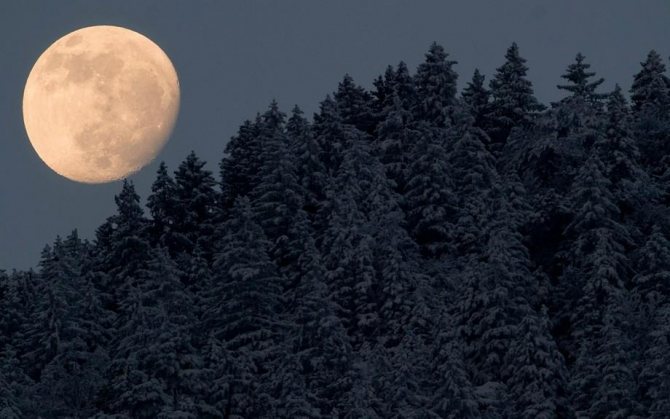
By seven o'clock in the morning, the Moon in the first quarter is also observed on the southern side of the celestial sphere.
Mysterious inhabitant of the Galaxy
Altair does not allow scientists near it; the capabilities of modern equipment are not enough to fully study its properties and features. If a person has a star in his horoscope, this adds qualities such as endurance, honesty, and fortitude. Many associate the phenomenon with legends and myths.
8 fun facts:
- Due to the high rotation speed, Altair's shape is ellipsoidal.
- The first high-quality photograph of the star was taken only in 2007.
- The clear color of the surface cannot be traced - it has an uneven bluish-white tint.
- Altair can change his radius. It depends on the angle of location.
- The body temperature of the luminary is not precisely known. Theoretically, this parameter, together with gravity and brightness, changes closer to the equator. It is directly affected by rapid rotation and different geographical locations.
- The star has barely visible disks, which were photographed in 2005.
- Inside the constellation Aquila, a mesmerizing sight takes place: Altair is surrounded by a bright glow - the Shining Eye. The nebula transmits rainbow tints to telescopes.
- The star's name is often used in films and games.
Have you watched: Cosmogony
According to one legend, the constellation Eagle was created by Zeus after Hercules killed his favorite bird. And among the Japanese, Altair is the patron saint of lovers who are ready to make sacrifices and madness for the sake of love.
Position of other constellations at different times of the year
How to navigate by the stars of other constellations? They can also help you understand in which direction of the world the right path is located. Astronomers are observing how the locations of constellations change. This happens not only at night, but throughout the entire calendar year.
At the midnight hour in the southern direction the following constellations will open to our gaze:
- Canis Major and Canis Minor (January);
- Leo (March);
- Bootes (May);
- Taurus (November);
- Orion (December).
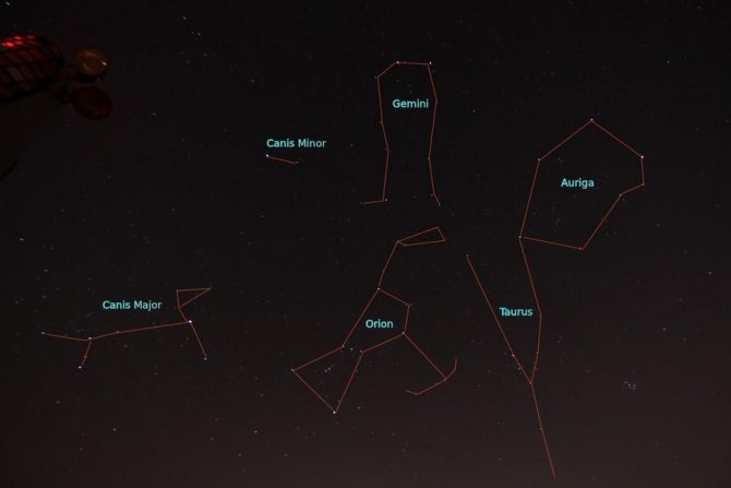
Our Galaxy, the Milky Way, is visible in the sky in a northern direction from the south and can sometimes serve as a good backup.
In what situations is it necessary to be able to determine azimuth and convert true azimuth to magnetic?
If you have to determine the direction of movement to a point invisible on the ground, then first you will calculate the true azimuth from the map. Next, to accurately find out the direction, you need to convert true azimuth to magnetic. Having done everything correctly, you will definitely get to the desired “point” - to a populated area, lake, river, etc.
The need to navigate by compass and azimuth often arises in the forest, in the mountains, in fog or in a snow or sandstorm, or at night. Following the direction determined by azimuth is the only way to move on ships in the sea and oceans, and on airplanes in the sky.
Such a simple but important skill is absolutely necessary for tourists and travelers who set off on their own, without guides.
I really love active recreation and try not to miss the opportunity to reconnect with nature! This year, when going on a hike through the forests of the Ukrainian Carpathians, I first of all decided to study navigation lessons and even then I discovered a new concept of azimuth. As it turns out, this is one of the most important concepts in orienteering, and it has a rather interesting origin.
Creation of a mini-observatory
In order to learn how to navigate by the stars, you can equip a small observatory anywhere. For it you will need two poles: one higher and the other lower. Next, you should observe the movement of large stars across the celestial sphere relative to poles dug into the ground. Remember that you can observe all stars except Polaris, which, as already mentioned, does not change its position relative to a person.
When any other star is moving up, it means we are looking directly east. The downward movement of the star means that we are observing the western part of the sky. When a star begins to “loop” to the right, it is north, and if it begins to make loops to the left, it is south.
The method is educational and interesting, but it only indicates the approximate direction of movement.
Orientation based on the North Star and other celestial bodies is a useful and fascinating skill that will definitely come in handy when traveling.
Observational data and orbit
At the Palomar Observatory, using a super-powerful interferomometer, measurements of Altair were made. The star is spinning so fast that astronomers have had trouble catching it. They found that the size of the celestial body changes. This became proof of the non-spherical shape.
Altair is included in the “summer-autumn triangle” as one of its peaks. This star is sometimes called Alpha, which, together with Gamma and Beta, creates the lineage - Val or Eagle Family.
Spectral, the star belongs to class A, located on the main sequence. In terms of mass and radius, it is almost twice the similar parameters of the Sun. The diameter of Altair within the equator and poles differs by 22%.
What is azimuth
In simple words, azimuth is the angle between the directions to the north and to some distant object
.
It is measured in degrees
: from 0° to 360°.
Being able to determine the azimuth angle is worth a lot - it will help you not get lost, be able to navigate when moving in the mountains, in the forest, in deserts, in conditions of poor visibility and when it is difficult or impossible to navigate on the map. Comes from the Arabic سمت (samt) - translated as path
,
road
,
direction
.
Order of movement by azimuths
The essence of movement along azimuths is to maintain on the ground the directions specified by magnetic azimuths (directional angles) and distances determined from the map. Directions of movement are maintained using a magnetic compass, and distances are measured in steps or using the speedometer of the car. This is the main method of movement in terrain poor in landmarks, especially at night and with limited visibility. To move along a given azimuth you need to:
- study on the map the area between the starting and final points of movement;
- outline a route that is easily recognizable by local objects;
- draw the chosen route on the map and determine the azimuths of all route links;
- determine the length of each route link on the map;
- Write down all the movement data in the field book in the form of a table or diagram.
When organizing the movement of a unit by azimuth, a guide is assigned, who determines the direction of movement using the compass and maintains it. In addition, two people are appointed to count the pairs of steps. If the distances on the diagram (in the table) are indicated in meters, they are converted into pairs of steps, taking into account the step size.
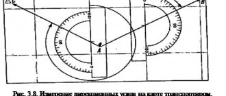
| Scheme for movement along azimuths | At point No. 1 (barn), the compass front sight indicator is set to 20° and the magnetic needle brake is released. Then the compass is turned in a horizontal plane until the northern end of the arrow is positioned opposite the zero division of the scale. The sighting line through the rear sight and front sight at this position of the compass will determine the direction to point No. 2 (mound). To maintain this direction along the way, some distant intermediate landmark is noticed on the line of sight, which is used to maintain the direction of movement. Before starting to move, the compass needle is put on the brake. The movement is performed strictly in a straight line in the direction of an intermediate landmark, while pairs of steps are counted. At an intermediate landmark, they again determine the direction using the compass, the magnetic azimuth of which is 20°, notice some distant intermediate landmark and move towards it. In this way, they move until 1230 m are covered. If the mound is visible even before approaching it, the last part of the site is passed without intermediate landmarks. |
Table of initial data for movement along azimuths
| Point number | Track section | Magnetic azimuth, degrees | Distance, m | Time, min | Distance, pairs of steps |
| Barn - mound | |||||
| Kurgan - forester's house | |||||
| Forester's house - crossroads | |||||
| Crossroads - bridge |
At point No. 2, they determine the direction using the compass, the azimuth of which is 330°, notice an intermediate landmark and begin to move, counting the pairs of steps. If there are no intermediate landmarks on the ground, for example in a forest, desert, steppe, then the direction of movement is maintained only by a compass. At point No. 3, they determine the direction whose azimuth is 25°, and move in this direction to the crossroads (point No. 4), counting the pairs of steps. From the above example it is clear that movement along azimuths is accomplished by sequential transition from one landmark to another. To make it easier to maintain the direction of movement, in addition to intermediate ones, auxiliary landmarks are often used. Such landmarks are usually the celestial bodies: the Sun, the Moon and bright stars. When using them, it is necessary to check the azimuth of the direction of movement after about 15 minutes, since the celestial bodies (except the North Star) move across the sky. If you move in their direction without control for a long time, you can significantly deviate from the route.
Azimuth movement
It consists in determining the desired direction on the ground at a given azimuth
and maintaining this direction on the way until reaching the intended point. During a hike, movement in azimuth is usually resorted to in closed areas or off-road, for which magnetic azimuths and distances to landmarks are determined in advance using a map.
Movement using intermediate landmarks
When moving in azimuth, practical accuracy of reaching a landmark
is usually up to one tenth of the route traveled.
Therefore, it is always advisable to mark intermediate landmarks along the route. To do this, before moving, set the compass sighting device to the desired direction and orient the compass
.
Then they sight in the desired direction (or near it) some clearly defined and not very distant landmark, towards which they move. Having reached the landmark
, the operation is repeated again. When determining the direction, you must ensure that the northern end of the compass needle coincides with the north mark on its dial.
When moving in azimuth, tourists may encounter significant obstacles along their path, such as a lake or a rocky area. To strictly maintain the general direction, it is advisable to go around them along a broken straight line with the least number of “elbows”. When walking around, you should clearly record the values of intermediate azimuths and the distances traveled along them.
In order not to stray from the right direction, it is useful to draw on a piece of notebook paper (on a tablet) while moving, a detour path with angles and lengths of “knees”.
Movement without clear guidelines
In the absence of landmarks
In the field, tundra, steppe, where there are no landmarks
, or in case of poor visibility, you can move
using the alignment method
.
The tourist leading the movement controls the direction, being at the end of the group: he sees the entire chain of tourists, can compare its direction with a given azimuth
and promptly warn about deviations.
If there is a sun (moon, stars), you can move in azimuth by measuring the angle of direction relative to these celestial bodies. Every half hour their position in the sky must be clarified using a compass. Of the techniques for such orientation, the most common is orientation by one's shadow.
In windy weather, it is useful to remember the direction of the wind or the movement of clouds relative to the sides of the horizon.
In wide open spaces in winter, snow sastrugi can be used to guide movement. In a densely forested area, in order to maintain direction, it is recommended to alternately bypass the encountered obstacles - trees, bushes, rubble - either from the left or from the right.
Sometimes, in the absence of intermediate landmarks, it is useful to make a deliberate deviation in a certain direction from a given azimuth. Having covered the distance calculated in steps or according to the time of movement to the final landmark, tourists turn sharply to the side and look in a new direction (one, and not in two opposite ones, as would be the case if they were moving straight along a given azimuth) for the desired point on the ground.
For large distances, it is necessary to mark out limiting (lateral) landmarks, and choose the final landmark as linear as possible and such that it is deployed with a wide front towards the direction of movement of tourists.