It is generally accepted that at noon, determined by the clock, the Sun is always due south, and to be precise, in the south direction. It was this statement that formed the basis of the method of orientation by the Sun and the clock.
In the northern hemisphere, indeed, at true noon the Sun is in the south.
However, this assumption is incorrect. And today we will try to understand this rather difficult issue, focusing on scientific data and logic.
Longitude of the area
True (astronomical), or as it is also called, solar noon often does not coincide with noon according to official time. To make this clear, let’s first look at the definitions.
The time 12:00, determined by an accurately set clock, is called noon according to official time. But true noon is the moment in time when the sun passes through the highest point of its trajectory observed from the surface of the globe, that is, through the zenith.
It is also worth noting that it is at the moment of true noon that the Sun for an observer located in the middle latitudes of the northern hemisphere is due south. We’ll tell you why in the middle latitudes a little later.
If you look at our planet from top to bottom, being at the north pole, then its movement around its own axis will occur counterclockwise. Knowing that the Earth revolves around the Sun, and not vice versa, it is not difficult to guess that the Sun will primarily illuminate the Earth from areas located to the east. This leads to two simple conclusions:
Conclusion No. 1. For an observer on the surface of the Earth, the Sun rises in the east and sets in the west, regardless of the hemisphere (northern or southern).
Conclusion No. 2. For two observers located at different geographical longitudes, the Sun will be at its zenith at different times: first, solar noon will occur for the one who is located to the east, and then for the “western” one.
You need to understand that for ease of use, time within one time zone is averaged, otherwise in two cities of the same country the time on the clock would be different, which is impractical. Therefore, despite the difference in longitude, the time in two different cities can be the same.
From the above it follows that for two observers located at different geographical longitudes, but in the same time zone, true noon can occur at different times. The advance or lag of the true noon from the noon determined by the clock, thanks to this nuance, can fluctuate within a quarter of an hour, and sometimes more, because time zones do not always exactly coincide with longitude and are lined up according to the political map of the world.
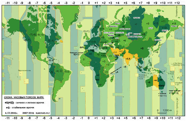
Time zones on the world map
And since solar noon does not always coincide with 12 noon (hereinafter referred to as 12:00), there is also no need to say that the Sun is always strictly in the south by this time.
You can see how the position of the Sun in the sky varies at the same time in different cities within the same time zone.
Now let’s return to the question of average latitude and see how it affects the position of the Sun in the sky.
Latitude of the area
As was said earlier, in mid-latitudes at true noon the Sun always passes through the southern direction. But let's see if the picture changes if a person observing the Sun turns out to be north or south of the indicated latitudes. To do this, let's look at a few key options.
Option No. 1 - mid-latitudes of the southern hemisphere. Here, during true noon, the Sun will be due north.
The fact that the sun at noon occurs not only in the south, but also in the north, unfortunately, is not written in all textbooks on tourism. But, thanks to various airlines, modern tourists can travel not only across their native expanses, but also easily end up in the opposite point of the globe, where the rules of orientation described in the literature will not work properly.
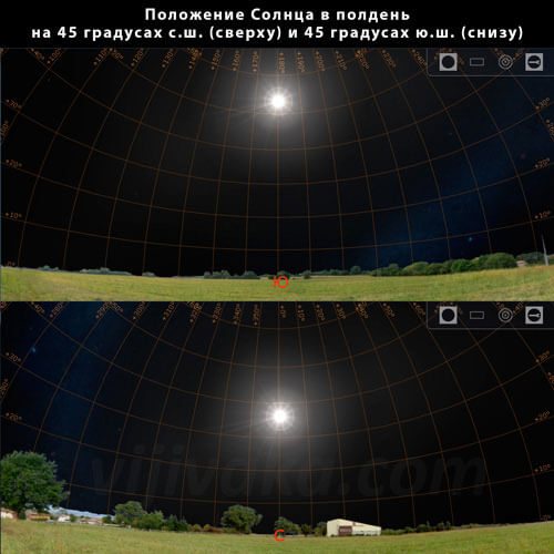
At the same time, the Sun will be at different heights at the same latitudes in different hemispheres.
Option No. 2 is the upper limit of the tropical zone of the northern hemisphere. In these territories, throughout the year, except for the summer solstice, at true noon the Sun will be in the south, and on the described day - strictly overhead. As you understand, it will not be possible to find the south, and, accordingly, other cardinal directions by the Sun in the latter case, unless, of course, we consider only the method of orientation by the Sun at noon.
Option No. 3 - the lower limit of the tropical zone of the southern hemisphere. Here, throughout the year, except for the winter solstice, the Sun at true noon will be in the north, as in the middle latitudes of this hemisphere. However, on the indicated December day it will be at the zenith directly above your head, which will not allow you to quickly navigate along it.
Option number 4 - equator line. In this zone, three options are possible, which will replace each other throughout the year. From the moment of the autumn equinox to the spring equinox, the Sun at true noon will be in the south, during the period from the spring to autumn equinox - in the north. And on the days of the equinox itself it will be directly overhead, causing difficulties in orientation.
It turns out that at the points of transition of tropical zones to temperate zones, the Sun stands at the zenith, that is, exactly above the observer’s head, only once a year, and closer to the equator this phenomenon can be observed twice a year.

Without knowing your own position on the ground, it is almost impossible to say whether the Sun is exactly at the zenith or not, without additional constructions.
I have come across the opinion that at the equator the sun is at its zenith every day at noon all year round. But, as we now understand, this assumption is wrong. In this region, at noon it is in the north for about half a year, and in the south for half a year. And even if we consider the zenith not the position of the Sun strictly overhead, but the highest point of its trajectory (which is also true), then the above opinion does not make much sense, since the Sun in this case is not only at the equator, but also at any other point on the planet every day the year will be at its zenith at noon.
In some tropical cities, people can observe an interesting picture: at midday, vertical straight objects, such as poles and fences, stop casting a shadow. This is due to the fact that the Sun at this moment is strictly above them, and the sun's rays and shadows from objects fall vertically. This video explains this phenomenon:
There is another option - the high latitudes of the northern and southern hemispheres. Here the Sun will behave in the same way as in the middle latitudes, but during the polar night it will not be possible to observe it above the horizon, and therefore to orientate yourself by it.
As we see, without understanding the processes underlying these differences, one can easily get confused and make serious mistakes, even to the point of confusing north with south. And for a traveler left without modern means of navigation in the wild, this can sometimes be tantamount to death.
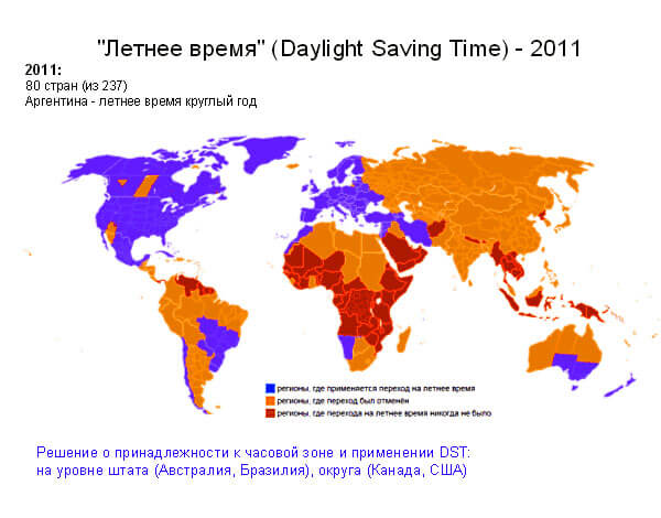
Changing clocks between summer and winter time
Changing clocks to daylight saving time is most often expressed by moving the clocks forward an hour. It is assumed that such a transfer helps save energy spent on lighting. However, there are a number of studies that have shown the absence of economic benefits from such manipulations. But that’s not what we’re talking about now.
If you do not take into account the change of clocks to winter and summer time, then you can make a big mistake when orienting yourself by the Sun and the clock. In mid-latitudes, such an error can reach 30 degrees, and in the tropics - many times more. Imagine how far you can go away from your destination if a deviation of one degree gives a deviation from the desired direction approximately equal to twenty meters for every kilometer of the distance traveled.
In Great Britain in the middle of the last century, due to the change to summer time, clocks began to be “ahead” of the Sun by as much as two hours. This happened because for two years in a row the clocks, as expected in the spring, were moved forward an hour, while in the first year in the fall the clocks were not moved back an hour. Afterwards, the “shortcoming” was resolved, and in history this event was called “British double summer time.”
In some countries, daylight saving time has been abolished and they use one time, while in others this transfer is still relevant. And there are a number of countries that have never known the “joys” of playing with clock hands.
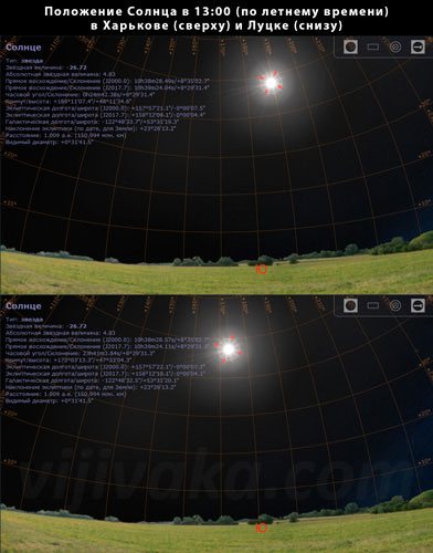
For example, at the time of writing (2017) in Ukraine, noon in winter time was closest to solar noon, and in the summer, the Sun is close to its zenith only when the clock shows 13:00. In Russia, they canceled the time change and left the clocks to run according to summer time, and now for Russians, solar noon occurs at 13:00, if you do not take into account other nuances that affect the discrepancy between the true noon and the noon marked by local time.
Equinox, me and my shadow. What time is noon?
Many will also remember that:
1. At noon, the shadows are shortest, and at the equator they generally hide under your feet. This property of midday is remembered, if not from school, then at least from the title of the once popular film “Shadows Vanish at Noon.”
2. At noon, the sun is exactly in the south, which allows you to navigate in an unfamiliar area with a watch (or by monitoring the shortening of the shadow).
It must be said that if we lived not in a specific state with its government, laws and decrees, but somewhere on a desert island, preferably without communication with the outside world, then noon for us would really come at twelve o'clock in the afternoon.
What does this mean? On the day of the spring or autumn equinox, the length of the day is equal to the length of the night. There are 24 hours in a day, of which 12 hours are light and 12 hours are dark. The sun rises at 6 am and sets at 6 pm. 18 - 6 = 12. Here it is noon!
The day after the equinox, the sun will rise a few minutes later (go earlier, depending on the time of year) and set the same number of minutes earlier (or later), but the middle will still be at 12 noon. And so all year round. On a desert island.
Simple common sense is good because it can be easily verified. So let’s check when it’s noon in our area. Let's use the properties of half a day 1 and 2 for this.
At 11.45, we will hammer a long nail into a table standing on a relatively flat surface, and place an accurate compass away from the nail. At 11.50, mark with a pencil on the table surface the position of the shadow of the nail head. And after that we will draw a line on the table pointing south. At 12.00 we again mark the position of the shadow of the nail; the shadow has become a little shorter. But the sun is not yet in the south! Suspicious. 12.10 - the shadow becomes even shorter! 12.20 is even shorter, 12.30 is even shorter. It becomes clear that either we are not on a desert island, or the properties of noon are “wrong,” or noon has not yet arrived. Common sense tends to favor the latter assumption (not to mention the former).
The inquisitive and patient will continue to measure the shadow, and he will need a lot of patience, because the shadow will become smallest only in an hour and a half, at which time the sun will finally creep to the south. What's the matter?
First of all, we didn't take daylight saving time into account. In the spring, everyone unanimously moved the clocks forward an hour and immediately forgot about it. Now noon began to arrive (daylight saving time) at one o'clock in the afternoon. But even at one o’clock in the afternoon our improvised observatory did not record the onset of noon.
Secondly, we forgot that we live in a country where maternity time is in effect. What it is?
“Maternity time was introduced by a resolution of the Council of People's Commissars of the USSR dated June 16, 1930 with the aim of more rational use of the daylight hours and corresponding energy savings. Maternity time is 1 hour longer than standard time"
- quote from the encyclopedia.
It turns out that noon occurs only at two o'clock in the afternoon in the summer.
During perestroika, at the peak of change, maternity time was abolished (in March 1991). I remember this year very well, it was one of the happiest years of my life. I remember how in the fall it began to get dark not at four o’clock in the afternoon, as usual, but at three, and no one liked it. Therefore, maternity time was quietly returned that same year; in the turmoil of that time, few people noticed it. Do you remember how once the clock was set not by an hour, but by two?
What do our observatory data show? At 14.00 the shadow is indeed close to its smallest size and the sun is close to the south direction, but again not quite accurate. What's the matter this time?
In time zones. Within the same time zone, for the convenience of residents, the time is considered the same. For example, at 14 o’clock Moscow time it happens in Vyatka and Pskov at the same time, and between them there is more than 1000 km in latitude.
How long will it take for the sun to “crawl” a thousand kilometers? About an hour. Anyone who has flown from the Far East to Moscow or St. Petersburg knows that there is no “time” wasted on the flight: both you departed at ten in the morning local time and arrived at ten in the morning, but already in Moscow time, although you sat on the plane 7 hours. And the plane flies at a speed of 900-1000 km/hour. Therefore, the sun moves at the same speed.
During the years of Prohibition, when alcohol was sold only from two o'clock in the afternoon, the “bridge over the Psou River” was known. This river separates Abkhazia from Russia (then still a single state of the USSR). It’s already two in Abkhazia, the shops are trading, but in Sochi it’s only an hour, so the thirsty people are running across the bridge over the Psou River. This is an example of how moving a few hundred meters changes time by an hour.
Likewise, the readings from your observatory, which measures the true time in your area, may greatly differ from the standard time of your region.
I made similar measurements at the longitude of Moscow, and it turned out that noon occurs between 13.35 and 13.45 (to get more accurate data, you need a very long nail and graph paper). Subsequently, I found data confirming the correctness of my measurements (the exact time of noon in Moscow is 13.40).
And if you have a GPS satellite navigation device, then it can easily tell you the exact time of noon in your area.
So decide what is more interesting, to spend time testing the laws of nature using common sense, or to spend this time to earn money for an expensive device. And how often do you need to know what time it will be noon?
Tags: compass, time, interesting fact, calculation, sun
Movement of the Earth around the Sun
The movement of the Earth around the Sun occurs not in a circle, but in an ellipse, while the Earth either approaches the Sun or moves away from it. At the moment when summer begins in the northern hemisphere, the Earth is at its maximum distance from the Sun, and in winter it approaches it.
Because of this, the solar day, that is, the time between two solar noons, changes throughout the year. Close to the Sun, the solar day lengthens, and when far away, it shortens.
This effect is superimposed on another effect associated with the tilt of the Earth's rotation axis.
The result is an interesting picture. If a person, being at one point on the earth’s surface (for example, take the average latitudes of the northern hemisphere), marks the position of the Sun on the celestial sphere at 12:00 every day throughout the year, then instead of the expected vertical line (in the summer the Sun will be higher , in winter - below) you get an elongated figure eight. This means that the Sun at noon, determined by the clock, can be either to the left or to the right of the south direction. The magnitude of these deviations on any day of the year can be found out by the so-called equation of time, which for convenience is tabulated or depicted as a graph.
If you do not take this effect into account, then when orienting in high latitudes you can get an error of about four degrees, and in tropical latitudes - ten or more.
Orientation around noon
Every day at exactly 12 o'clock solar time the Sun is exactly in the south. The time we live by, which our watches show, is not solar time. For different cities, solar time differs differently from the time shown on the clock. On average, our clocks are 1 hour ahead of solar time. Therefore, according to our clocks, the Sun is in the south not at 12 o’clock, but at about 13 o’clock.
Therefore, we get the following rule:
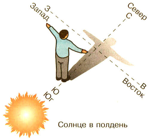
If you stand facing the Sun at about 13 o'clock, then there will be south in front, west on the right, east on the left and north behind.
When the Sun is in the south, it stands highest above the horizon, and at this time the shadows from objects are the shortest. Therefore, you can do without a watch and absolutely accurately determine the position of the sides of the horizon by observing the change in the length of the shadow of some object.
At about 12 noon, stick a stick vertically into the ground. Check that the installation is correct using a plumb line (weight suspended on a thin rope). Watch the shadow of the stick and from time to time mark the position of the shadow with a peg, pebble, etc.; you will see that the shadow is turning, and at the same time it will first shorten, then begin to lengthen.
The direction of the shortest shadow is due north (Fig. 3).
Rice. 3 Fig. 4
Notice this direction for some object that is far from you (house, tree, bushes, etc.). If the moment when the shadow was the shortest is missed for some reason, then you can do this: mark two positions of the shadow from a vertically standing stick - one before noon, the other after noon, when the length of the shadow is the same. The north directions lie midway between the directions of these identical shadows (Fig. 4).
How to determine true noon
Knowing true noon, you can determine the cardinal directions, because at this very moment the Sun will be strictly in the southern or northern direction, depending on the earth's hemisphere, and knowing at least one cardinal direction - all the others.
True noon can be determined in different ways. Below I will give examples of some simple options that do not require complex skills and knowledge.
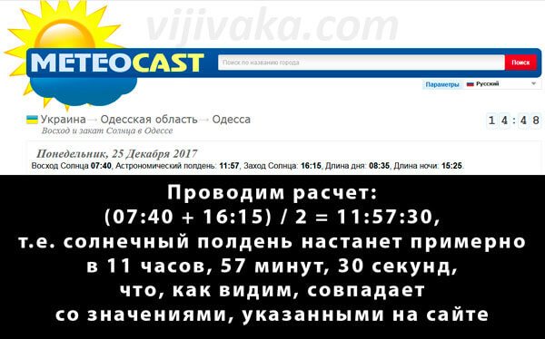
Method number 1 - using astronomical data. Such data is often found among weather forecasts in various print and Internet publications. You need to look for the time of sunrise and sunset in the area in which true noon is supposed to be determined, add up this time and divide it in half. The resulting value will be the time of true noon.
Method No. 2 - using a sundial (gnomon). A properly designed, marked and installed sundial shows the time of solar noon quite accurately. On the gnomon, the moment of solar noon coincides with twelve o'clock of the day.
Method number 3 - using a navigator. A navigator showing the direction to geographic north can serve to determine the onset of true noon. To do this, determine the moment when the center of the solar disk is strictly above the southern or northern direction (depending on the earth's hemisphere), determined using a navigator. This will be the moment of true noon.
A magnetic compass is of little use for this method, since it shows the direction to the magnetic poles, and not to the geographical ones, which can lead to noticeable errors. We talked in detail about what the true and magnetic poles are and what their differences are in a separate article.
Method number 4 - using a shadow from a pole. On a flat horizontal platform, an even pole is stuck strictly vertically into the ground. Before lunch, the measurement of the length of the shadow cast on the site by the pole begins. The shadow will initially begin to decrease and then increase. The moment of transition from shortening the shadow to its lengthening will correspond to solar noon.
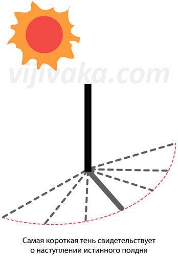
In this option, it is enough to detect the time at which the shadow was of the smallest length.
This method is one of the methods of orientation and is often recommended in the literature for determining the cardinal directions on the ground in sunny weather. Its accuracy directly depends on how level the platform and the pole itself were chosen, as well as on how level this pole was installed. Also, the accuracy of the method increases with increasing pole length (as a rule, a pole 1-2 meters long is used).
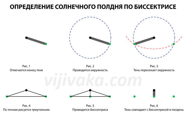
Method No. 5 - using a bisector. Measurements begin as early as possible in the morning, which makes them more accurate. For this:
- A pole is installed on a flat area in the same way as the previous method and the end of its shadow is marked.
- The distance from the pole installation site to this point is measured.
- A circle is drawn with a radius equal to this distance and center at the point where the pole is installed. Now all that remains is to wait for the shadow of the pole to cross this circle again, but in a different place (to the east).
- Once this happens, the second point is marked.
- The first and second points are connected by a segment - a kind of isosceles triangle is obtained, the third vertex of which is the location of the pole.
- A bisector is drawn from the pole installation point, which divides the segment previously drawn between two points in half.
- The next day, when the shadow of the pole coincides with the bisector, we can say that true noon has arrived.
This method, like the previous one, is also one of the methods of orientation by the sun.
Of all these options, only the first can work under any meteorological conditions, at any time of the day and give quick results. The rest work only during daylight hours, are dependent on the weather and, as a rule, are slower.
Now, based on all of the above and some other data, we will draw general conclusions.
How to determine cardinal directions by shadow
So, as promised, let's look at some of the most popular methods.
Method No. 1. Along the shortest shadow from the pole. This method is based on the fact that at noon the shadows of objects are shortest. So:
- A pole is stuck vertically into a horizontal, flat area.
- Before noon, the end of the shadow cast by a pole is marked on the site.
- Such notes are made at short intervals.
- When the shadow begins to lengthen in the afternoon, all marks are connected by a smooth curve.
- On the curve, find the point closest to the pole and mark it.
- Draw a line from the pole to this point. This line corresponds to the north-south direction.
- They stand on this line so that it is parallel to the feet joined together, and the morning marks are to the left. Now the north is in front of the person, the south is behind him, the east is on the right, and the west is on the left.
If, from the moment the first point was marked, the shadow began to lengthen, this means that noon has already passed, and you need to wait until the next morning to repeat everything again.
Most solar orientation methods will require additional constructions.
Method No. 2. Using the shadow of the pole in the center of the segment. This method is based on the fact that the Sun rises in the east and sets in the west, and the right side of its trajectory across the sky is a reflection of the left. For this method:
- As in the previous method, a pole is stuck vertically into the platform.
- In the morning, a mark is made on the site, corresponding to the end of the shadow from the pole.
- The length is measured from the pole to this mark.
- Closer to lunchtime, the length of the shadow decreases, and then begins to grow again. The shadow is measured periodically. As soon as it becomes the same length as the morning one, make a second mark corresponding to the end of the shadow.
- A straight line is drawn between the first mark and the second. This line corresponds to the east-west direction.
- The person stands so that the first mark is to his left, and the second to his right. Now we can say that in front of him is north, behind him is south, on the right is east, and on the left is west.
You can read about other variations of these methods in the article about where the sun is at noon...
These two methods make it possible to relatively accurately navigate by the shadow of the Sun anywhere on the planet (except for regions near the poles and at the poles themselves) during daylight hours, but they require a lot of time, which makes them of little use for a person who needs to navigate along the way.
Method No. 3. Using the shadow of a pole at two points. This method is based on the knowledge that the sun rises in the east and sets in the west, and the shadows of objects move from west to east, although not always in a straight line. To navigate this way:
- As before, a pole is stuck vertically into a flat horizontal area.
- On the site, the end of the shadow from the pole is marked with a stone, peg or any other convenient method.
- Wait about 15 minutes and make a second mark corresponding to the end of the shadow from the pole.
- Now, if you stand on the first mark with your left foot, and on the second with your right foot, north will be in front of us, south behind us, east will be on the right, and west on the left.
This method, like the previous ones, can be used anywhere in the world during daylight hours, but differs from them in its speed. However, this method has problems with accuracy.
The fact is that the shadow of a pole in most cases during the day draws not a straight line, but a curved one, and in relation to the position of the pole, this line can be either concave or curved, depending on the latitude and time of year. If you do not take these points into account, you can get a colossal mistake, so I will give my recommendations that will allow you to use this method with maximum efficiency. There are only two such recommendations.
Recommendation #1. It is better to use this method in March and September. It gives maximum accuracy throughout the day on the days of the spring and autumn equinoxes, since it is on these days that the shadow “draws” a straight line. The further you move away from these days on the calendar, the greater the error will be.
Recommendation #2. It is better to navigate using this method in the middle of the day. On any day of the year, this method shows the best results at lunchtime. The further from solar noon, the greater the error of the method. Moreover, the error can double if, for example, you take your bearings 3 hours before noon and then repeat the measurements 3 hours after noon.
Method No. 4. Orientation by shadow and clock. This method is based on the fact that at 12 o'clock in the afternoon the Sun in the northern hemisphere is approximately in the south, and in the southern hemisphere - in the north, at 6:00 - approximately in the east, and at 18:00 - approximately in the west. Accordingly, the shadow cast by a person falls in the direction opposite to the Sun.
So, for example, if you stand with your back to the Sun at noon, then in the northern hemisphere the shadow will be directed to the north, in the southern hemisphere - to the south. If you turn your back to the Sun at 6 o’clock in the morning, the shadow will point to the west, and if you do the same at 6 o’clock in the evening, then the shadow will point to the east. Having determined one side of the world in this way, you can then find all the others.
A typical picture for the northern hemisphere.
If you have to navigate along the way, then there is no need to look for a flat area every time to stick a stick into it and then wait a quarter of an hour. Once you have your bearings, it is enough to understand which side the Sun is on and then choose the path relative to its position in the sky. For example, if, turning in the right direction, a person sees the Sun on the right, then during the transition, he must keep it on the right. In this case, over time, you can make corrections for the speed of the Sun, and during rest, you can clarify the direction using the described method.
When using this method, it is important to remember that in some countries the clocks are switched to daylight saving time and that the Sun at noon in the tropics and equator can be on both the northern and southern sides throughout the year, which we discussed in a separate article . In addition, in it we also talked about other effects that affect the position of the Sun at noon, and therefore negatively affect the accuracy of the described method.
Method No. 5. Orientation by the shadow of a match and a mechanical clock with hands. This method is described in some military textbooks and is based on the understanding that in the northern hemisphere the Sun moves clockwise across the sky at an angular speed of 15 degrees per hour. To navigate this method in the northern hemisphere:
- The clock is placed horizontally with the dial up.
- A match is applied to the side of the clock, perpendicular to the dial. It is applied between the hour hand of the watch and the number “12” on the dial. So, for example, if the clock shows 8:00, the match is located near o, but if the clock shows 20:00, then near o.
- The watch and the match are turned until the shadow of the match crosses the center of the dial.
- When the shadow of the match coincides with the center of the dial, the number “12” will show the approximate direction to the south.
This method works well only in cases where the Sun, passing its highest point, is not high above the horizon. The higher it is at noon, the greater the error this method will produce.
The fact is that the speed of the Sun's projection onto the horizon not only does not coincide with the angular speed of the Sun, but also varies during the day. These differences are greater the higher the solar zenith.
That is why this method of orientation is best used at high latitudes. In mid-latitudes, it is better to use it in the winter season, when the Sun is at a low altitude above the horizon. In the tropics and at the equator, this method is usually not used, since here the Sun is high above the horizon at any time of the year, which means the errors will be very large.
In this method, as in the previous one, the clock change to daylight saving time should be taken into account. Other nuances are usually not taken into account, since the method still gives a fairly large error and is intended primarily for approximately finding the cardinal directions.
In principle, you can slightly reduce the error by raising the edge of the dial, on which the number “12” is marked, by an angle equal to the difference of 90 degrees and the latitude of the area in which the person is located. For example, for a latitude of 35 degrees, the watch needs to be raised to an angle of 55 degrees. But, as my practice has shown, such a tilt in some situations not only does not reduce the error, but also increases it, since it is already difficult to position the match exactly perpendicular to the dial, holding it with your fingers, let alone the option with the tilt of the dial. But the result of orientation will also depend on the accuracy of setting the match.
In the southern hemisphere, this method must be changed, otherwise it will show results that are far from the truth. Personally, in this case I imagine a dial with numbers located counterclockwise. Accordingly, if the clock says 10 o’clock in the morning, I imagine the hour hand pointing to the number “2”; if the clock says 16:00, then I imagine the hand pointing to “8”. Next, I proceed as described in the method, but focusing not on the real arrow, but on the imaginary one.
This method is good for approximating the cardinal directions and usually produces the largest errors compared to the previously discussed methods. But unlike them, it allows you to orient yourself within ten seconds, which is very practical and allows you to determine the cardinal directions almost on the go.