The cardinal directions are easiest to determine in sunny weather at noon.
- You need to stand with your back to the sun and the shadow you cast will point to the North in the Northern Hemisphere and to the South in the Southern Hemisphere
- The Sun rises exactly in the east only on March 21, and sets in the west on September 23. On other days, it should be taken into account that 6 a.m. is in the east, 9 a.m. morning - in the southwest, 12 o'clock. in the south, 15h. in the southwest, 18h. - in the West.
For Russia, maternity time must be taken into account. Those. Noon occurs not at 12, but at 13:00, everything else is also shifted an hour later. In the summer, many countries, including the Russian Federation, introduce summer time. This means that noon is at 14.00.
- The highest position of the Sun is determined by the length of the shortest shadow, which corresponds to noon, and its direction points exactly to the north. But this is only true between the North Pole and the Tropic of the North
- In equatorial regions, the midday shadow is directed north for six months (from September 23 to March 21), and south for half a year (from March 21 to September 23)
- At latitudes between the equator and the tropics, the shadow also changes direction, although for a shorter time
- Without waiting for the shortest shadow, you can navigate in the following way. Stick a stick about 1 meter long into the ground. Mark the end of the shadow. Wait 10-15 minutes and repeat the procedure. Draw a line from the first shadow position to the second and extend one step beyond the second mark. Place the toe of your left foot opposite the first mark, and the toe of your right foot at the end of the line you drew. You are now facing north
- Beyond the Arctic Circle, you can estimate the location of the cardinal directions by the sun and at night, because The sun does not go far beyond the horizon; the northern side of the sky at midnight is the lightest, the southern side is darker.
The easiest way to determine the north-south direction is by the Sun and the clock
The watch should be placed horizontally and the hour hand should be directed towards the Sun (it will be easier to point the arrow directly at the sun if you align the arrow with the shadow of a vertical object, such as the edge of a wall, a fence post or a plumb line). Then mentally draw line A from the center of the dial to the number 1 on the clock. If you now draw a bisector through the angle formed by this line and the clockwise hand (i.e., divide the angle in half with the drawn line), then the bisector will indicate the North-South direction. or the noon line, and the south will be to the right of the Sun before 12 o’clock, and to the left after 12 o’clock. The measurements will be more accurate the further you are from the equator. In mid-latitudes the error can reach 20°. The bisector of the angle between the hour hand and 12 on the dial will point south. For example, if the clock shows exactly 4 o'clock in the afternoon, then with the hour hand pointing towards the sun, the number 2 on the dial will point south. This method is suitable for determining directions during the day, namely from 6 am to 6 pm. In the polar regions, where in summer the sun does not set until 6 am and after 6 pm, this method will indicate the direction not to the south, but to the north. If your watch is not mechanical, but electronic, you can draw a dial on a piece of paper, draw the hour hand in the position at the time of measurement and orient the drawing to the sun, as described above. In the summer, many regions have an unpleasant habit of introducing daylight saving time, so noon in the summer there occurs not at 12 o'clock, but at 13. Therefore, the angle in this case should be measured between the hour hand and the number 1. In the territory of the USSR, and now the Russian Federation, another etc. maternity time, moving noon another hour. Those. In our country, summer noon begins at 2 p.m. Therefore, the angle should be measured between the hour hand and number 2. Fewer problems arise if the watch dial has not 12 divisions, but 24. In this case, it is enough to point the hour hand towards the sun, and the beginning of the scale will immediately point to the south.
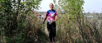
One of the most important skills for those who like to travel or simply relax as savages is terrain orientation. In this article we will look at the main ways to determine the sides of the horizon.
Having this information, you will not get lost even under the most difficult conditions. The main condition is the presence of a card. Otherwise, you will have to rely on logic and assumptions. However, you can easily determine your location.
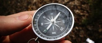
Compass
We will begin to study ways to determine the sides of the horizon with the easiest and most obvious. Using a compass you can easily find out where north is. There are only a few mandatory conditions. What do you need to know so that this device does not let you down?
Firstly, it is possible to determine the cardinal directions only when the compass is in a strictly horizontal, stationary position, and the needle has stopped oscillating.
Secondly, within a radius of fifty meters around you there should be no railway tracks, transformers or other sources of electromagnetic or magnetic radiation. Otherwise, the compass will deviate from the correct course or the needle will begin to spin and behave incomprehensibly.
How to use this device correctly?
The most common are the two military compasses - Adrianov and artillery, as well as sports varieties. They differ only in price levels and the presence of certain scales.
In any device, on top, on the lid, there is a special sight, through which you can determine the landmark. So, hold the compass horizontally and wait until the needle stops. Its dark end will point to the north. Now we turn the sight so that its vector coincides with the arrow. Now the cardinal directions are easy to determine. If you are looking north, the south will be behind you, the east will be on your right, and the west will be on your left.
Watch
Determining the sides of the horizon by the clock is one of the most interesting, unusual and effective methods. To implement this, a mechanical watch with hands is required. Electronic ones will not work.
This method is a little similar to determining the sides of the horizon by the sun, since we cannot do without the sun. What features does this method of terrain orientation have?
First, there are different options for determining location in the morning and in the afternoon. The time limit is one hour in the afternoon (13:00).
Secondly, the clock must be accurate.
So, we position the device so that the hand that shows the hour (often it is thicker and shorter than the others) looks at the sun. Next, you need to draw an imaginary angle that will connect two lines in the center of the dial. One will coincide with the hour hand, and the second will pass through the number “one”.
After this, we divide the angle in half with an imaginary straight line. The south will be ahead, the median line will indicate it.
The peculiarity is as follows. Until one o'clock in the afternoon we measure the arc from the hand showing the clock. That is, the path that she still needs to go through before 13:00. And after this time we draw an imaginary arc counterclockwise. Therefore, we are now measuring the distance she has already traveled after one o'clock in the afternoon.
The figure above will help you better understand this method of orientation on the ground.
For approximate orientation, it is also useful to know the following:
In the event that true midnight occurs exactly at 1 o'clock in the morning (which in Russia and Europe approximately corresponds to the actual state of affairs), then in the summer the Moon in the first quarter of its phase (7 days after the New Moon) in the evening at 19.00 is located in the south, at 1 one o'clock in the morning (that is, at our agreed midnight) - in the west... But in the last quarter of its phase, the Moon will be in the east at midnight, and at 7.00 am - in the south. When there is a full moon, the sides of the horizon are determined in the same way as by the Sun and the clock, and the Moon is taken to be the Sun.
This is interesting: Nature - waterfalls, rivers and lakes of Crimea
Determining the sides of the horizon by lunar phases and time of day
Of course, in addition to the New Moon, full moon, first and fourth quarters, there are many more other (intermediate) nights. Therefore, intermediate states/phases of the Moon can also be taken into account and the direction determined from them. True, this will be even more approximate.
- The appearance of the Moon - full, young, aging or growing (that is, its phases), as well as the time of rising and setting depend on the stage of its cycle (every night it rises and sets about 50 minutes later than the previous night, hence the 29- daily lunar cycle).
On clear nights, the full Moon (and even + - a couple of days) shines so brightly that objects and objects cast shadows and you can determine the approximate direction to the sides of the horizon using a stick stuck in the ground (this is a little more accurate than just calculating by looking at The moon and drawing mental lines from it)... But we will not describe this method, because in practice we did not have a chance to use it. It seems that this method takes a lot of time.

Humanity has always strived for precision, wanting to conquer the elements and the surrounding space. Since ancient times, orientation by celestial bodies has been considered an honorable occupation.
And lunar orienteering was no exception. The knowledge and skills needed to survive have always been in demand.
Over the centuries, humans have used a wide variety of methods for navigating the terrain. In all eras, astrologers, astronomers, cartographers, and pathfinders set a high price for their work, because their services were used by both ordinary travelers and adventurers, and large expeditionary, trading and military organizations.
Such data was vital when it was necessary to organize an expedition, send a rescue squad, or carry out a military maneuver. Any activity on a large scale, involving movement over long distances, required precision.
And for the average traveler, lunar navigation will become an important skill. Methods for determining cardinal directions have evolved and changed.
The Europeans followed tried and true methods, using sophisticated sextants and other delicate instruments. But some continued to stick to traditional and familiar methods.
Expert opinion
Makarov Igor Tarasovich
Hunter and fisherman with 20 years of experience. Wildlife lover
Aborigines used the services of indirect landmarks in the area, and sailors always looked closely at the starry sky. Celestial bodies are the best of guides, because they are constant and their movement is calculated.
Impervious to the passage of human time, they do not deteriorate or become overgrown with moss, thus becoming a universal and flexible tool for determining location. Such instruments include the natural satellite of our planet – the Moon.
Needle
According to many tourists, the following definition of the sides of the horizon on the ground is the most unusual. In addition, additional equipment and skills are required to implement it. From the outside it looks more like a circus trick. So what do we need?
- Metal needle for sewing. It will become the needle of our makeshift compass.
- Something that will give the needle buoyancy properties. This can be vegetable oil (we generously lubricate the metal rod with it or drop it onto the surface of the water), a small piece of cork or polystyrene foam. The main condition is that the needle must float in a horizontal position.
- The metal rod must be magnetized. This can be done using a magnet, a piece of wool or some other available means. For example, in the case of a needle, the most ordinary scissors would be a good choice. All you have to do is snap the ends together as if you were trying to cut a needle in half. From the rapid friction of metal on metal, the rod will begin to magnetize.
- Container with water. This could be some kind of container or, for example, a hole in a tree or stone filled with standing water.
The main sides of the horizon (in the presence of all the above items) are determined simply. A well-magnetized needle that floats on the surface of the water will rotate along the “south-north” line under the influence of the planet’s magnetic field.
The only inconvenience is that it will not be clear which side is which. This will have to be determined in additional ways.
But this method is completely suitable for insurance purposes. In addition, it is very indicative of teaching children location orientation and explaining the principles of magnetic fields.
Heavenly bodies
The sun moves across the sky at an angle of fifteen degrees in one hour. People have been guided by it for a long time. But to more accurately determine the cardinal directions, it is worth knowing some features.
In summer, the Sun moves along the southern side of the sky. Therefore, it rises not in the east, but in the northeast. Sets down, respectively, in the northwest.
In winter, the same picture is repeated, only from the north side. In spring and autumn, the sun rises and sets in the east and west.
The second feature on which the determination of the sides of the horizon by the sun is based is the length of the shadow. In principle, the shortest shadow occurs around one in the afternoon. It points to the north if the object is motionless and in a strictly vertical position.
For a more accurate understanding of the location, it is worth using other methods of determining the sides of the horizon. For example, with a mechanical watch, which was described above.
At night, when there is no light, it is easiest to navigate by the North Star. This part, as astronomers say, is located near the axis of the north pole of the world and is practically motionless, unlike other stars. Therefore, it is very easy to determine where north is.
How to find this star? First you need to find the Big Dipper in the sky. This constellation is in the form of a large bucket with a handle. Depending on the time of day, it can be located vertically, horizontally or at an angle.
Now you need to mentally continue the line that connects the two stars that form the front wall of the bucket (opposite the handle). If you extend it to a distance five times greater than the length of the segment, you will come across the North Star.
You can clearly see how to do this in the figure on the left.
Sides of the horizon and methods for determining them
It is necessary to remember that if you stand facing north, then the east will be on your right hand, the west will be on your left, respectively, the south will be behind your back . To determine the sides of the horizon, the following methods can be recommended:
- by compass;
- by the Sun and analogue clock;
- by the Sun and digital clock;
- using improvised means;
- for local facilities;
- according to the North Star;
- on the Moon.
Let us consider in more detail the indicated methods for determining the sides of the horizon, as well as the recommended sequence of their development during training sessions.
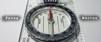
Determining the sides of the horizon using a compass . A magnetic compass is a device that allows you to determine the sides of the horizon, as well as measure angles in degrees on the ground. The principle of operation of a compass is that a magnetized needle on a hinge rotates along the lines of force of the Earth's magnetic field and is constantly held by them in one direction. The most common are various versions of the Adrianov compass and the artillery compass.
Rice. 5.1 Adrianov's Compass
1 — cover with stands for sighting; 2 — dial; 3 — count indicator; 4 — magnetic needle; 5 - brake
Adrianov's compass (Fig. 5.1) allows you to measure angles in degrees and inclinometer divisions. A dial with two scales is used to measure angles. Degrees are marked in 15° intervals (division value is 3°) clockwise, protractor divisions are marked in 5-00 intervals (division value is 0-50). The dial reading is read using a pointer mounted on the inner wall of the compass cover opposite the front sight. The northern end of the magnetic needle, the reference and division indicator on the dial, corresponding to 0°, 90°, 180° and 270°, are covered with a glow-in-the-dark composition. There is a mechanism that slows down the movement of the arrow.
Rice. 5.2 Artillery compass
1 – compass body; 2 – rotating dial body; 3 – dial; 4 – compass cover with a mirror “a”, a cutout for sighting “b” and a latch “c”; 5 – magnetic arrow; 6 – protrusion of the brake lever arrows
The artillery compass (Fig. 5.2), thanks to some improvements, is more convenient to use than Adrianov's compass. Its body is rectangular, which allows you to accurately position the compass along the map lines and draw directions. The compass cover with a mirror surface allows you to observe the position of the magnetic needle and at the same time sight the object. The magnetic needle more steadily records the direction of the magnetic meridian; Its braking is carried out by closing the lid. The scale division value is 1-00, their signatures are given after 5-00 clockwise.
Determining the sides of the horizon using the Sun and an analog clock . This fairly convenient and accurate method of determining the sides of the horizon is used if the Sun is visible, or it is determined through the clouds.
Rice. 5.3
Analog watches are held in a horizontal plane and rotated until the hour hand aligns with the direction of the Sun, the position of the minute hand is not taken into account. The angle between the hour hand and the number “1” on the watch dial is divided in half. A line dividing this angle in half will indicate the direction to the south (Fig. 5.3). It is important to remember that before one o'clock in the afternoon the angle not traversed by the clock hand is divided in half, and after one o'clock in the afternoon - the angle which it has already passed.
Determining the sides of the horizon using the Sun and a digital clock . This method of determining the sides of the horizon is used when the light of the Sun is sufficient for objects to cast a shadow.
On a horizontal surface (on the ground) a circle with a diameter of 25-30 cm is drawn with a point in the center. Then, on the outer side of the circle from the side of the Sun, a small load (for example, a bunch of keys) is suspended on a rope or cord so that the shadow of the rope passes through the center of the drawn circle. Next, through the point of intersection of the shadow from the rope with the sunny side of the circle and the center of the circle, a radius is drawn, indicating the hour hand of an imaginary clock. Using a digital clock, the actual time is specified, according to which divisions of an imaginary dial are drawn in the circle.
Further, as on an analog watch, the angle between one o'clock in the afternoon and the drawn hour hand is divided in half (before one o'clock in the afternoon the angle not passed by the hour hand is divided in half, and after one o'clock in the afternoon - the angle which it has already passed). The resulting direction is south (Fig. 5.4).
Rice. 5.4 Determining the sides of the horizon using the Sun and a digital clock
Determining the sides of the horizon using available tools . The situation becomes more complicated when on a cloudy day it is impossible to determine exactly where the Sun is. However, even in this case, there are ways to fairly accurately determine the sides of the horizon.
Rice. 5.5 Determining the sides of the horizon using a float and a needle
A flat round float with a diameter of 15-20 mm and a thickness of 5-6 mm is made from bark or a piece of wood. A shallow diametrical cut is made on the float, into which it is necessary to carefully place the needle and lower the float onto the existing water surface (any puddle; water poured into a plastic or wooden container; a small depression in the ground, lined with a plastic bag and filled with water from a flask, etc. ). Under the influence of earthly magnetism, the needle will certainly turn and, swinging between east and west, will be positioned with its tip to the north and its ear to the south, that is, along the magnetic force lines of the Earth (Fig. 5.5).
If there is no needle, then a thin steel nail or steel wire can replace it. But in this case, it is important to remember that the needle turns with its tip to the north due to the peculiarities of the manufacturing technology - the so-called “broaching”. With a piece of wire or a nail, the direction of pulling is unknown; therefore, it is unclear which end points to the north and which to the south. Therefore, for alignment, it is necessary to perform the same operations once near a noticeable landmark (anthill, growth rings, etc.) as with a needle, then mark the end of the wire or nail that will turn to the north. Interesting fact: even an automatic cleaning rod on a float of the appropriate size can play the role of a compass needle - the cleaning rod will always turn to the north with a thread (true only for AKs manufactured before 1984).
Determining the sides of the horizon using local objects . The sides of the horizon can be determined by local objects, but it must be remembered that the error in this case may be 15-20°.
- One of the most reliable indicators of the sides of the horizon are forest anthills - they are usually located at the roots of a tree with a thick crown that protects them from rain and always on the southern side of this tree. In addition, the southern side of the anthill is always flatter compared to the northern.
- The next, albeit not as reliable indicator as an anthill, is moss on stones and trees. Moss, avoiding direct sunlight, grows on the shady northern sides of stones and trees. Using this method, you need to be careful: since there is no direct sunlight in a dense forest, moss grows around the entire surface of the tree - at its roots and above. The same goes for stones. Accordingly, this method “works” well only on isolated trees or stones. Or, as a last resort, in open forests.
- The sides of the horizon can be determined by the annual rings of trees. To do this, you can find a free-standing stump or cut a small, free-standing tree with a diameter of 70-80 mm. Having carefully cleaned the cut, we will see that the core, that is, the center of the concentric annual rings, is shifted relative to the geometric center of the stump, and it is necessarily shifted to the north. By drawing a straight line through the geometric center of the stump and the center of the concentric annual rings, we get the direction to the north.
- The bark of most trees is coarser on the north side, thinner and more elastic (birch is lighter) on the south.
- In pine, the secondary (brown, cracked) bark on the north side rises higher along the trunk.
- On the north side, trees, stones, wooden, tiled and slate roofs are covered earlier and more abundantly with lichens and fungi.
- On coniferous trees, resin accumulates more abundantly on the south side.
- In spring, the grass cover is more developed on the northern outskirts of the meadows, warmed by the sun's rays, and in the hot period of summer - on the southern, darkened ones.
- Berries and fruits acquire the color of maturity earlier (turn red, turn yellow) on the south side.
- In summer, the soil near large stones, buildings, trees and bushes is drier on the south side, which can be determined by touch.
- Snow melts faster on the southern sides of snowdrifts, resulting in the formation of notches in the snow - spikes directed to the south.
- In the mountains, oak often grows on the southern slopes.
- Clearings in forests are usually oriented in the north-south or west-east direction.
- The altars of Orthodox churches, chapels and Lutheran kirks face east, and the main entrances are located on the west side.
- The altars of Catholic churches (cathedrals) face west.
- The raised end of the lower crossbar of the church cross faces north.
- Kumirni (pagan chapels with idols) face south.
- On Christian graves, the gravestone or cross stands at the feet, that is, on the east side, since the grave itself is oriented from east to west.
Determining the sides of the horizon by the North Star . Let us recall the remarkable property of the Polar Star - it is practically motionless during the daily rotation of the starry sky and, accordingly, is very convenient for orientation - the direction towards it practically coincides with the direction to the north (the deviation from the north point does not exceed 3°).
To find this star in the sky, you must first find the constellation Ursa Major, which consists of seven fairly noticeable stars located so that if you connect them with an imaginary line, a bucket will be drawn.
If you mentally continue the line of the front wall of the bucket, approximately 5 distances equal to the length of this wall, then it will rest against the North Star (Fig. 5.6).
If you are in the mountains or in the forest, you may not see the bucket if it is currently located under the North Star. In this case, another noticeable constellation will help - the Constellation Cassiopeia. This constellation is formed by six fairly bright stars and represents the Russian letter “Z” when located to the right of the North Star, and the irregular letter “M” when located above the North Star.
Rice. 5.6 Finding the North Star in the sky
To find the North Star, you need to mentally draw a median from the top of the large triangle of the constellation (i.e., a straight line connecting the top of the triangle with the middle of the opposite side) to its base, which, when continued, will rest against the North Star (Fig. 5.6).
Determining the sides of the horizon by the Moon . The sides of the horizon are determined on a cloudy night, when it is not possible to find the North Star. To do this, you need to know the location of the Moon in various phases (Table 5.1)
The table shows that it is most convenient to determine the sides of the horizon during the full moon. In this phase, the Moon is at any time in the direction opposite to the Sun.
| Moon phases | Moon location | ||
| In the evening (at 19-00) | At night (at 01-00) | In the morning (at 07-00) | |
| First quarter (right half of disc visible) | On South | In the West | — |
| Full Moon (entire disk visible) | In the east | On South | In the West |
| Last quarter (left half of disc visible) | — | In the east | On South |
Table 5.1
Movement in azimuths
Movement along azimuths is a method of maintaining the intended path (route) from one point (landmark) to another along known azimuths and distances. Movement along azimuths is used at night, as well as in the forest, desert, tundra and in other conditions that make it difficult to navigate on the map.
Determining the direction on the ground at a given azimuth using Adrianov's compass . By rotating the compass cover, the pointer is set to a reading corresponding to the value of the specified azimuth. Then, having freed the magnetic needle, turn the compass so that the zero stroke of the dial aligns with the northern end of the needle. At the same time, they stand facing the desired direction and, raising the compass to approximately shoulder level, sight along the slot-front sight line and notice some landmark on the ground in this direction. This direction will correspond to the specified azimuth.
Determining the direction on the ground at a given azimuth using an AK artillery compass . The compass cover is set at an angle of 45° and by rotating the dial, the given reading is aligned with the pointer at the slot in the cover. The compass is raised to eye level and, observing in the lid mirror, is turned until the zero stroke of the dial aligns with the northern end of the arrow. In this position of the compass, one sights through the slot and notices any landmark. The direction to the landmark will correspond to the specified azimuth.
Measuring magnetic azimuth with Adrianov's compass . Having freed the magnetic needle, turn the compass to draw a zero stroke under the northern end of the needle. Without changing the position of the compass, by rotating the ring, direct the sighting device with the front sight towards the object to which you want to measure the azimuth. Aiming the front sight at an object is achieved by repeatedly moving the gaze from the sighting device to the object and back; For this purpose, you should not raise the compass to eye level, since this may cause the needle to move away from the zero stroke of the dial and the accuracy of azimuth measurement will sharply decrease. Having aligned the sighting line of the front sight slot with the direction towards the object, take a count from the front sight pointer. This will be the azimuth of the direction to the object. The average error in measuring azimuth with Adrianov's compass is 2-3°.
Measuring magnetic azimuth with an AK artillery compass . Having placed the compass cover at approximately an angle of 45?, sight the object. Then, without changing the position of the compass, by rotating the dial, while observing in the mirror, bring the zero stroke of the dial to the northern end of the magnetic needle and take a reading from the pointer. The average error in measuring azimuth with an AK artillery compass is approximately 0-25.
Preparing data for movement along azimuths . The route is marked on the map with clear landmarks at turns and the directional angle and length of each straight section of the route are measured. Directional angles are converted into magnetic azimuths, and distances are converted into pairs of steps if the movement is on foot, or into speedometer readings when marching in cars. Data for movement along azimuths is drawn up on the map, and if there is no map along the way, a route diagram (Fig. 5.7) or a table (Table 5.2) is drawn up.
Rice. 5.7 Route diagram for movement along azimuths
| Landmark number and name | Magnetic azimuth, degrees | Distance | |
| in meters | in a couple of steps | ||
| 1 – separate yard | — | — | — |
| 2 – the place where the road enters the forest | |||
| 3 – intersection of clearings | |||
| 4 – hole near the clearing | |||
| 5 – forester’s house |
Table 5.2
The order of movement in azimuths . At the initial (first) landmark, using a compass, the direction of movement to the second landmark is determined by azimuth. They notice some distant landmark (auxiliary) in this direction and begin to move. Having reached the intended landmark, they again mark the direction of movement using the compass to the next intermediate landmark and so continue moving until they reach the second landmark.
In the same order, but in a different azimuth, they continue moving from the second landmark to the third, etc. On the way, taking into account the distances covered, they look for landmarks at the turns of the route and thereby control the correctness of the movement.
To make it easier to maintain the direction, you should use the celestial bodies and various signs: the straightness of a walking column or your own track when moving on skis, the direction of ripples in the sand and sastrugi in the snow (sastruga is a long and narrow snow bank swept by the wind), wind direction, etc. Based on the celestial bodies, you can confidently maintain the direction of movement, clarifying it with a compass approximately every 15 minutes.
The accuracy of reaching a landmark depends on the accuracy of determining the direction of movement and measuring the distance. Deviation from the route due to the error in determining the direction using a compass usually does not exceed 5% of the distance traveled. If the direction of movement is clarified by the compass often enough, then the deviation from the route will be about 3% of the distance traveled.
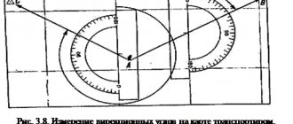
Avoiding obstacles . If there are obstacles on the route, then detour routes are marked on the map and the necessary data is prepared for this - azimuths and distances. Obstacles not taken into account when preparing data for movement are avoided in one of the following ways.
Rice. 5.8
The first method is used when the obstacle is visible to the end. In the direction of movement, mark a landmark on the opposite side of the obstacle. Then they go around the obstacle, find the noticed landmark and continue moving from it in the same direction; The width of the obstacle is estimated by eye and added to the distance traveled to the obstacle.
Second way. An obstacle, the opposite side of which is not visible, is walked around in directions forming a rectangle or parallelogram, the azimuths and lengths of the sides of which are determined on the ground. An example of such a bypass is shown in Fig. 5.8. From point A they go along the obstacle in the chosen direction (in the example - in azimuth 280°). Having passed to the end of the obstacle (to point B) and having measured the resulting distance (200 pairs of steps), they continue to move along the given azimuth (in the example - along the 45° azimuth) to point C. From point C they enter the main route along the reverse azimuth of direction AB (to example - along an azimuth of 100°, since the reverse azimuth is equal to the forward azimuth ±180°), measuring 200 pairs of steps in this direction (distance CD equal to AB). Here the length of line BC is added to the distance traveled from point No. 2 to point A, and movement continues to point No. 3.
The buildings
The main sides of the horizon are very easily determined near buildings of sacred significance.
These can be Orthodox churches or Catholic churches, chapels, mosques, synagogues. Each of these buildings is built according to its own strict laws.
If there is an Orthodox church, cathedral or temple nearby, you need to look at the lower crossbar. According to legend, the feet of Christ were located there. It is beveled diagonally. Its upper edge is directed towards the north.
Altars in Catholic churches are located in the west, and in Lutheran and Orthodox churches - in the east.
There are other local signs of determining the sides of the horizon. Thus, the entrance of mosques and synagogues is located approximately in the northern part of the building. According to these religions, a person entering a building should face Mecca or Jerusalem, respectively.
In East Asia, Buddhist buildings usually face south. The yurts of the indigenous peoples of Siberia also have an entrance from this side of the world.
Clearings are traditionally made in forests. They are usually cut either from east to west or from north to south.
Natural objects
Many methods for determining the sides of the horizon have long been known. To do this, people used observations of trees, animal behavior and other features of the environment.
For example, due to the abundance of light and heat in the summer on the south side, berries and fruits ripen faster and have richer colors on the side facing this direction. On freshly cut trees, the rings on the south side are wider than on the north. This is explained by the same abundance of sunlight and heat.
There are other signs of determining the sides of the horizon. The anthills on the northern side are steeper, and on the southern side they are flatter. It is also believed that icicles form more often on the south side of the roof.
If there are pine trees nearby, the south can be easily determined from them. On this side, their trunks will be lighter and the bark will be rougher. And also there will be much more resin streaks on it than on the northern side of the tree. The grass is greener in the south in summer and turns yellow earlier in the north.
The most popular method is to pay attention to the amount of moss on the stones. It is believed that these plants like to settle on the north side.
Mushroom picker's reminder
- Trees growing in open areas have longer and thicker branches to the south, and the trunks on the north side are covered with moss.
- There are more spots on the trunks of birch trees on the north side.
- You can determine the cardinal directions by the cuts on the stumps: the annual rings on the southern side are wider, and narrower on the northern side.
- On stumps and boulders, the soil on the south side is drier than on the north side, and moss grows on the north side.
- Ripe lingonberries and cranberries are brighter in color on the south side and lighter on the north.
- On coniferous trees, resin accumulates more abundantly on the south side.
- An anthill near a tree trunk, stump or stone is located on the south side.
- Bees usually build their nests on rocks and in tree holes facing south.
- If you are walking far into an unfamiliar forest without a compass, then try to remember any noticeable landmarks along the way: swamps, a stream, a river, a lake, a path, a road, the noise of a car on a highway, the sound of wheels on a railway, as well as country roads with high-voltage electricity. power lines, poles, towers, unusual trees, intersections, forks in roads, etc.
- It is best to bypass the swamp; few mushrooms grow there.
- The direction North -> South is not difficult to establish using a watch. To do this, the watch is placed in a horizontal position with the hour hand pointing towards the sun. The angle between the hour hand and the direction towards number 12 on the clock dial is divided in half. A line passing from the center of the clock through the middle of the corner will always indicate the direction North -> South. Remember that before 12 o'clock the south will be to the right of the sun, and after 12 o'clock to the left.
- At night it is not difficult to navigate by the moon. The full moon is opposite the sun, which means that at seven o'clock it is in the west, at noon in the south and at 19 o'clock in the east. A straight line drawn mentally through the two extreme stars of the Big Dipper, which has the shape of a bucket, will go to the bright Polar Star, which is always in the north in our hemisphere.
- You can tell the time using the so-called “green clock”. There are quite a few plants that have the property of opening and closing their flowers at the same time. Thus, rosehip opens its thorns at 4–5 o’clock, poppy at 5, dandelion at 5–6 o’clock, flax at 6–7, loach at 8, coltsfoot at 9–10, fragrant tobacco at 20, violet - at 21 o'clock.
- In spring and summer, a mushroom picker can quite accurately navigate in time by the voices and singing of birds. So, long before dawn, the trills of a nightingale are heard - this means it is 2 o’clock in the morning. At 2–3 o'clock the robin and skylark awaken, and at about 3 o'clock the quail wakes up. By 3 o'clock the cuckoos wake up. At about 4 o'clock the chaffinch and bunting sing at once, a little later - the starling and wagtail. And only the couch potato sparrow sleeps until 5 am.
- Remember that in the second half of summer the sun is in the east at 7 a.m., in the south at 1 p.m., and in the west at 7 p.m.
- Flowers and plants are sensitive to weather changes. They can help the mushroom picker determine the weather for the coming days. Before bad weather, wood sorrel and wood grains disappear, sweet clover and dandelion flowers smell strongly, and the flowers of coltsfoot and thistle close.
- Other natural phenomena can predict the weather. The birds in the forest stopped singing - there will be bad weather. Mosquitoes hover in a bunch - it means cold weather, and if they squeak and sting, it will be rainy. If the smoke from the fire rises in a column - towards the bucket, spreads along the ground - there is bad weather. The spider arranges its web like a wheel - there will be clear, dry weather.
This is interesting: How to determine geographic coordinates on a map: longitude and latitude
Many companions accompany the mushroom picker during the mushroom season: morning and evening dawns, fog and dew, flowers and plants, pine forests and birch forests. The main thing is to be attentive and observant in case the right direction is lost. It can be determined by the signs known to you.
Since ancient times, in order not to get lost in the forest while going for mushrooms or berries, people have used folk signs of orientation, which remain relevant today. The isolation of modern man from nature and his close connection with technical means of navigating the area, such as a navigator and other gadgets, make him vulnerable to nature in the event of losing his bearings in the wilderness with faulty means of communication or in their absence.
Therefore, it is still very important to be able to recognize the signals of nature in your favor in order to correctly navigate any terrain.
Lichens and mosses
When determining the characteristics of the sides of the horizon, you need to use complex results. This especially applies to natural phenomena and flora.
Earlier we mentioned the most common way to find the north side. It consists in the fact that you just need to look at a tree trunk or stone. The moss should be on the north side. But if this really happens, you are incredibly lucky. This happens once every hundred trees, or even more. Why is this so? What is the reason?
It's simple. These plants love shade and humidity. It is assumed that it is on the northern side that such a microclimate is formed. But in the forest the conditions are actually completely different. It all depends on the terrain, surrounding bodies of water or mountains.
In addition, you may find yourself near the edge of the forest. Ignore the cutting and, guided by the position of the moss and lichens on the trees, mark the north. Before this, the trunks you see were in the shadows deep in the forest. It was only after cutting down that they turned out to be the outskirts.
The same applies to the buildings we talked about earlier. Traditionally they should be built as we have already mentioned, but today everything is changing. Some architect decided to innovate and make a door in a different place.
Therefore, be sure to use the signs as a whole, or better yet, take a compass with you.
Folk signs for navigation
Natural orientation signs are different. Using them you can determine the cardinal directions both in dense forests and in clearings.
- Signs of orienteering in the forest
If you find yourself in a forest, take a closer look at the trees. The side of the trunk on which thick moss or lichen is located faces the northern part of the world.
There is much less vegetation on the western or eastern side of the tree, and practically no moss or lichen grows on the southern side. The sign with lichen or moss on stones works in a similar way.
The part of the trunk facing south tends to have longer and denser branches.
Signs of orientation along the crust
Birch is a good helper for orientation. The part of the birch trunk facing north is covered with more frequent spots than the part that “looks” to the south. The southern part of its trunk is always smoother, cleaner, without any damage. Often the trunks of birch trees seem to turn to the north side, sometimes almost touching the ground.
Cranberries or lingonberries growing on the north side are lighter in color than those growing on the southern side of the area.
The tree bark is much cleaner, harder and lighter in color on the southern part of the trunk than on the northern part. For greater reliability, it is recommended to study the trunks of several trees.
Tree crowns and tree rings will also help you navigate. In the southern climate zone with dry summers, the growth rings are thickened on the northern part of the trunk, and on the same side the tree has a more developed crown.
In the northern zones, on the contrary, the tree is more developed on the southern side, i.e. with the one where he is most comfortable.
If a tree's branches lean to one side or have fewer branches on one side, the prevailing wind is blowing in that direction. If you pay attention to several such trees and notice the direction of the wind, then you can make the return journey by moving towards it.
This will help, if not to go astray, then at least to return to a place located not far from the starting point of departure.
If the summer is hot and dry, you can take a closer look at coniferous trees, for example, pine or spruce: the south side of the trunk will release much more resin than the north.
You should pay attention to mushrooms and red saffron milk caps. From year to year they grow in the same place. At the same time, saffron milk caps growing on the southern side of the forest have a dryish cap of a bluish-greenish color. On the southern side of the forest, the berries ripen faster than on the northern side, and the snow melts here much faster.
Once in the mountainous regions of the south, you will notice that the southern slopes of the mountains contain oak and pine trees, while the northern slopes contain beech, fir and spruce.
In the forest, not only trees and plants, but also insects can become assistants in determining the cardinal directions. So, ants build their anthills in the southern part from stumps, trees or stones. At the same time, the southern side of the anthill is always flatter than the steep northern one.
- Orientation on terrain without forest
Expert opinion
Makarov Igor Tarasovich
Hunter and fisherman with 20 years of experience. Wildlife lover
Once in an open clearing, you can navigate along its outskirts: on the northern side of the forest clearing, the grass grows thicker than on the southern side. However, this sign is only valid in spring.
The grass growing on the northern part of a single stump or stone is not as tall and dense as on the southern part. Around mid-summer, the grass growing on the south side begins to turn yellow.
This is interesting: How to determine absolute height on a map
But on the north side it remains green.

Signs of navigation by berries
The berries always ripen faster from the southern part of the meadow than from the northern one. Steppe gophers always orient their burrows to the south.
Plants often indicate cardinal directions. For example, sunflower flowers never face north. The leaves of steppe lettuce face their planes towards the west and east, and their ribs towards the south and north.
In addition to determining the cardinal directions, in the forest you can determine the time by birdsong. So, the nightingale begins to sing at about two o'clock in the morning, the sparrow begins to chirp closer to five in the morning, and the chaffinch, wagtail and bunting begin to make sounds at four o'clock in the morning.
It should be noted that all folk signs of orientation often depend on the climate zone, the nature of the terrain and other factors. So, for example, if in a forest moss is always located on the north side, then near reservoirs it can grow in relation to any part of the world.
The same fact is influenced by the degree of inclination of the tree trunk, the direction of the wind rose, the topography of the earth, etc. The same can be said about an anthill, since living creatures adapt to the terrain, regardless of the location of parts of the world.
Therefore, it should be said that you need to be able to navigate by signs, but take into account the characteristics of a particular area and the subjectivity of these signs.
Modern man moves more and more away from nature and ceases to feel it. No wonder.
After all, the connection with nature is lost as we become familiar with modern technologies, the comfort and convenience that they create. But being cut off from all this, a person will become helpless; he will not even be able to orient himself in space and understand which way he needs to go.
lettuce
There are also quite extravagant ways of determining the horizon with the cardinal points. This includes the so-called “compass plants”. They usually have one or more permanent traits that gradually become fixed as they mature.
Such plants, for example, include compass lettuce. Externally, it looks like a very large dandelion with small yellow flowers. Over time, like their younger brother, they become fluffy parachutes.
However, it is completely unrelated to the ordinary dandelion. Rather, lettuce can be called its relative.
In fact, compass lettuce is a weed. It grows almost everywhere in the steppe zone of the former Soviet Union. You can find thickets of it in the fields, and isolated plants along the roads.
Its peculiarity is that it hides the delicate surface of the leaves from the sun's rays. Lettuce turns them sideways. And when the plant matures enough, they freeze in this position. Not always, but very often the leaves indicate a line from north to south.
If you decide to use this method exclusively, it is better to find a thicket of lettuce. Because a single plant may be an exception and will confuse you.
Sunflower
Now we will study the last “plant” method of determining the direction of the sides of the horizon. To do this, we need one, or better yet, several sunflowers growing nearby.
Children have known since school that a plant turns with the sun. That is, in the morning it looks east, and in the evening it turns out to be turned to the west.
However, this is not quite true. If you carefully follow the life of a sunflower through its different stages, you may be very surprised. It turns out that over time, when the flower plate appears from the bud and forms, the plant freezes.
A fully open sunflower will never turn to follow the sun. He always looks where the first morning rays appear. If it is an open place, then the flower will be directed towards the northeast or east.
If there are obstacles nearby, the sunflower will look exclusively in the direction from which the first rays appear. In this case, you cannot rely on it.
How to navigate by the moon and the clock
Deep night, dark sky. There are no stars visible, and there is only one month on the horizon, and you need to determine your location (Figure 2). How to correctly navigate the moon in such conditions?
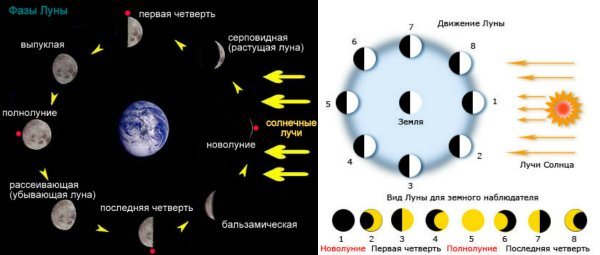
Figure 2. Moon phases will help you navigate the area
Take a close look at the lunar disk. What do you see?
- You see a C-shaped area that is illuminated, the rest is dark. In this case, it is an aging sickle completing the remainder of its revolution around the Earth;
- What you see is a reverse C, which looks more like a piece of the letter D if you draw a straight line between the ends of the sickle. This is called a growing sickle;
- You see a full lunar disk, equal on each side. This means that the luminary is parallel to the sun and points south at midnight. If you make a 180 degree turn, you will be facing west.
This is interesting: Where is the polar star in the sky relative to Ursa Major
There is also one fairly simple method - orientation by the moon and the clock (Figure 3). The lunar calendar is slightly different from the ordinary one, because the months in it are correlated with the phases of the satellite. Having such a tool with you, you can also easily determine the position of the month.
Now, knowing how the star is turned towards the planet, let's consider ways to navigate the Moon:
- You will need an ordinary watch, or another disk, divided into 12 equal parts.
- Visually divide the lunar disk into a segment with 12 equal parts, and then count the number of segments that fall on the illuminated part of the disk.
- Check your observations with time, and if you see an aging sickle, add to this number.
- If this is a growing phase, then you need to do exactly the opposite and subtract the resulting number.
- This result tells us where the satellite would be in full phase at the same time.
- Knowing that in full phase the light is always parallel to the sun, you can easily determine the cardinal directions.
- Now point the resulting sector of the dial at the satellite itself. In the winter season, the south will be one division higher than planned, and in the summer – two divisions higher.
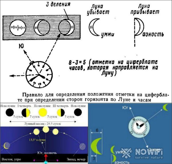
Figure 3. A regular watch and an Earth satellite will help you determine your location.
The alternative method is a simpler operation. Divide the lunar disk into six sections, then count the number of illuminated areas.
Now point the watch at 12 at the satellite. The next step is to add to the mark the result of counting the highlighted areas if the light is aging, and subtract it if it is growing.
Example - three of the six sectors of the segment are illuminated, you add 3 more to 12, and you get 15. The sun will be in this direction, and, therefore, the south.
You can also use pre-checked satellite positions at certain times of the day. If the phase is the first quarter, then at seven o’clock it will be in the south, at one in the morning in the west, and in the morning after seven o’clock it will no longer be visible.
The last quarter of the revolution at one in the morning will point to the east, and at seven in the morning to the south.
Modern technology
Modern technology allows you to navigate the terrain only using the device screen. We are talking about a professional navigator or a regular mobile phone with the Internet.
However, the reality is that the network does not catch everywhere. Therefore, even the GPS should be turned on before entering the forest in order to mark the place where you will need to return. For example, you are standing near the first line of trees and, judging by the instrument, you are looking southeast. So you will return to the northwest. This is the direction we remember.
Second important point. If suddenly the connection is lost and the navigator or map is no longer active, an unusual solution will help. Turn on the analog dial on your mobile phone in the “alarm clock” section. Now you have an electronic version of a clock with hands. And then we proceed as described above.
Thus, dear readers, today we have learned to determine the sides of the horizon on the ground. This is a useful skill that will undoubtedly be useful to mushroom pickers, hunters, lovers of wild recreation or travelers.
In the forest lies a large stone-boulder, overgrown with fluffy moss on one side. Look carefully at this unusual compass, which was created by nature itself. We have already written about different, and with. We recommend reading these interesting articles.
Sides of the horizon
The horizon is distinguished in four main directions:
- northern;
- southern;
- western;
- eastern.
In addition, there are intermediate sides - northwest, southwest, southeast and northwest of the horizon.
To navigate in space, you need to be able to correctly recognize the sides of the horizon on any terrain. This is especially important in a forest or in a city where the horizon line is hidden by tall trees or buildings.
This is quite easy to do. At noon, the sun is in the southern part of the sky, and shadows from objects will fall towards the north. Turning your face to the north, the south is behind you. In this position, the east will be on the right hand, and the west will be on the left.
For greater convenience in orientation on the ground, a very useful device was invented - a compass. Its structure is very simple: it is a round dial indicating the direction of south, north, west and east. A magnetized steel arrow is attached in the center, which points north in any position.
Rice. 3. Compass.
Orientation by moss and lichen
Mosses and lichens do not like heat and light, so they grow in the shady side. This means that where there are mosses and lichens, there is north; on the south side there is less or no moss at all. Now orienteering on moss
It won't give you any difficulties.
You can also determine the direction by looking at the soil around the stone. On one side it is relatively dry (south), and on the opposite side it is wetter (north).
Usually an old, rotting stump is overgrown with moss on all sides. But to determine where north and south are, you need to check the moisture content of the moss, not the soil.
Anthill navigation
Another natural compass that will always help you find the right direction in the forest is anthills
. Most of them are located on the south side of a tree, stump, or bush, since ants are heat-loving insects. The southern side of the anthill is usually sloping, the northern side is much steeper.
Anthill navigation
Anthill navigation
Quite easy to remember and understand.
In the tundra, as well as in white moss forests (more details:) and taiga swamps in the north of the European part of the USSR, in Western and Eastern Siberia, in the Far East, lichens (moss, or reindeer moss) of the genus Cladonia grow, which serve as an indispensable food for northern deer, especially in winter. Sources of valuable antibiotics and enzymes, they can also serve as a compass. Darker than the entire lichen, the tips of their branched bushes always face north. Therefore, when going north, you see the dark surface of the moss (lichen) cover, when moving in the opposite direction, that is, to the south, the dark color is not visible, and the bushes seem lighter
Sides of the horizon. Orientation presentation for a lesson on the world around us (grade 2) on the topic
Slide 1
Sides of the horizon. Orientation
Slide 2
Goals and objectives of the lesson 1. Learn to determine the sides of the horizon using a compass; 2. Get acquainted with new concepts: horizon, sides of the horizon, orientation.
Slide 3
Horizon The horizon is the space visible to the eye. The imaginary line that limits it is called the horizon line.
Slide 4
1. Orientation – the ability to find the sides of the horizon. 2.Navigate the terrain - correctly determine where is east, where is south, where is west, where is north, that is, find the right direction. 3.The easiest way to determine the sides of the horizon is by the sun.
Slide 5
The main sides of the horizon There are four brothers in the world: North, South, East and West. These brothers are the countries of the world, Well, their home is the whole planet. Every day we see sunrise in the morning, the highest Sun at noon, sunset in the evening and the North Star at night. These landmarks give 4 points on 4 different sides of the horizon. They were named: East - the side of the sunrise; South is the side of the Sun at noon; West - sunset; North is the side of the North Star.
Slide 6
Intermediate sides of the horizon There are also intermediate sides of the horizon.
Slide 7
Think about it! Why do we need to know the sides of the horizon?
Slide 8
What is a compass? A compass is a device for measuring the sides of the horizon
Slide 9
RULES FOR OPERATING WITH THE COMPASS 1. Place the compass on a horizontal surface (or palm) 2. The compass needle must be stationary. After this, turn the compass box so that the letter “C” on the compass scale coincides with the dark end of the magnetic needle. You have oriented the compass and prepared it for use.
Slide 10
How to find the sides of the horizon without a compass? You can navigate by the Sun, stars or local signs
Slide 11
Orientation by the Sun If at noon you stand with your back to the Sun and spread your arms, then the shadow falling from you will indicate the North, the South will be behind you, the East will be on the right, and the West will be on the left.
Slide 12
Orientation along the anthill Ants make their homes on the south side of the tree and make the southern slope of the anthill flatter than the northern one.
Slide 13
Orientation by moss Tree trunks and stones are covered with moss on the north side more densely than on the south.
Slide 14
Orientation by bird flight In autumn, birds fly south, and in spring, north.
Slide 15
Check yourself. 1. Orientation – the ability to find the sides of the horizon. 2.Navigate the terrain - correctly determine where is east, where is south, where is west, where is north, that is, find the right direction.
Slide 16
Warm-up for the mind The edge is visible, but it is impossible to reach it. horizon A blue sheet covers the whole earth. firmament Golden flowers bloom in the sky in the evening, and fade by morning. stars
Slide 17
On the road, in an unknown land - everywhere he is your best friend. One capital letter “Y” on it marks the south. Both in the taiga and in the ocean He will find any path. Fits in your pocket, and leads us along! compass
Slide 18
Thank you for your attention !