What is orienteering
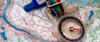
Orienteering is a sport in which athletes use a compass and map to search for control points located on the ground. The classic way for athletes to move is running, but there are various variations: cycling, skiing, combined starts. The winner is the participant who finds all the points and comes to the finish line first. The most important qualities of an athlete: the speed of completing the distance, the correct choice of the route and the accuracy of its implementation.
For beginners, the process may seem complicated, but with some patience, understanding comes and what is initially confusing turns into an exciting task. There is no other sport that tests both the mind and body in the same way. Are you already convinced? If not, then read on for some very good reasons why you should take up orienteering today!
Compass and magnetic declination
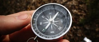
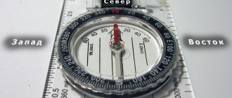
But many orienteering methods are only good in clear weather. A reliable all-weather way to determine direction is a compass. Its blue needle points north, but the magnetic compass needle is located along the magnetic, not the geographic, meridian, which almost always do not coincide.
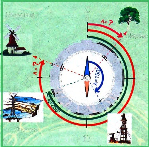
Azimuths to objects
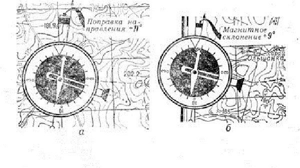
If you need to determine a more accurate direction, you will have to understand what magnetic declination .
This is the angle between the north direction of the geographic meridian and the direction of the blue end of the magnetic needle. In other words, magnetic declination is the angle between the magnetic and geographic meridians at a given point in a given historical era.
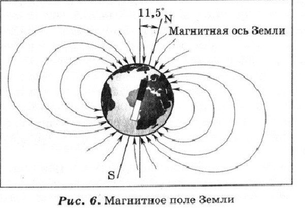
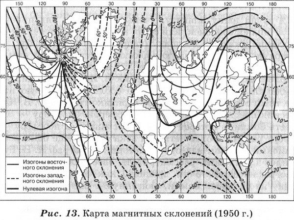
The axis of the Earth's magnetic field forms an angle of 11° with the axis of its rotation, therefore the Earth's magnetic poles do not coincide with the geographic ones. Like the geographic poles, the magnetic poles change their position, although their annual displacement is only a little more than 20 km. Here's how the coordinates of the magnetic pole of the Earth's Northern Hemisphere changed:
- 1890 – 79° N. sh.; 119° W d.;
- 194 6 – 74° N. sh.; 92° W d.;
- 1950 – 74° N. sh.; 100° W d.;
- 1958 – 70° 5′ 30″ N. sh.; 96° 45′ 3″ W. d.;
- 1970 – 71° N. sh.; 96° W d.;
- 1975 – 76° N. sh.; 100° W d.;
- 1980 – 77.5° N. sh.; 102° W d.
This is interesting: How water is disinfected with ultraviolet light and what is needed for this
Now the North Magnetic Pole is located in the area of the Sverdrup Islands group (part of the Canadian Arctic Archipelago) at a distance of 1,400 km from the North Geographic Pole. Every day it moves along an elliptical path and on average moves more than 40 m to the north per day.
Magnetic declination is either eastern or western. When the northern end of the magnetic needle deviates east from the geographic meridian, the declination is called eastern, is positive and is indicated by a plus sign; when calculating, it must be subtracted and the degrees returned to the left.
When the arrow is inclined to the west - western (negative in relation to the true meridian), having a minus sign, in order to find out the true direction, the degrees must be returned to the right, i.e.
add.
Eastern declination
Long-term observations have shown that every place on Earth has its own declination. Based on the results of the research, scientists began to compile magnetic maps. The first map of magnetic declination was compiled by the English explorer Edmund Halley in 1701.
All topographic maps indicate magnetic declination. For example, the magnetic declination of Moscow is +8, that is, you need to count 8° west from the direction of the northern end of the magnetic compass needle - subtract it. This will be the direction to the north.
To accurately determine the direction to an object, it is necessary to indicate the true (geographic) azimuth - an angle that is measured from the northern end of the geographic meridian clockwise to the direction to the object (from 0 to 360°).
The most reliable way to navigate is a topographic map + compass. In this case, you need to move in azimuth. To correctly find the road using a map or plan, you need to be able to calculate the distance from it. The following lesson is devoted to the topics of scale and measuring distances.
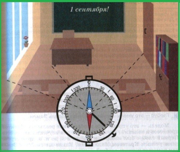
Azimuth to objects in the classroom
Orienteering is a head sport
The main task for the orienteer is to find a balance in the struggle between the physical and psychological components of the race. There is a distance here, but it is non-linear - it is impossible to simply run the fastest without regard to tactics. The winner is not the one who runs the fastest, the one who runs the fastest along the most correct and shortest route wins. Correct and quick decision-making plays a very important role in the orientation process. “Run straight through the swamp or around it? Do I need to go down into the ravine or take a workaround?” These constantly evolving tasks require lightning-fast decision-making at the level of instincts, under conditions of competitive intensity and accumulating fatigue.
Method of orientation by melting snow
We continue to talk about what orientation in geography is. We have not yet described all of its methods. This article only talks about the main ones. One of the most common methods is to navigate by melting snow. The south side of all objects is known to heat up more than the north. This means that snow melts faster on this side as well. This is clearly visible in early spring, as well as in winter, during thaws, from the snow stuck to stones, holes near trees, and the slopes of ravines.
This is a full body workout
Orienteering is not just off-road, it is running without trails. Once you have mastered the easy beginner routes, you will want to try more challenging orienteering. The terrain can vary from beautifully runnable pine forests to heather-strewn moors and heavily overgrown areas. You may end up jumping over streams, off fallen trees, or through thickets. This requires a lot of energy and good strength training. This is why the orienteering distances are quite short. But try running a 7K road race and compare it to a 7K orienteering race. After which of them will you wake up in the morning with pain not only in your legs, but throughout your whole body? :)
Orienteering in the forest
In the literature there are recommendations for determining the sides of the horizon based on the tree crown. But the indication that the crown of trees on the south side is more luxurious, and the annual rings of wood growth on the stump of a cut tree from the south are wider than from the north, is not always confirmed.
Expert opinion
Makarov Igor Tarasovich
Hunter and fisherman with 20 years of experience. Wildlife lover
The fact is that in a deep forest the trees cover with their shadow the neighboring trees located to the north of them. Therefore, longer and denser branches in the middle of the forest can be directed not only to the south, but also to the north, east, west, i.e.
that is, where there is more free space.
In this regard, the annual increase in the next layer of wood is formed on the side from which the tree develops better. So, not necessarily from the south side.
And if we also take into account that the development of the tree crown, as well as the width of wood growth, is constantly influenced by the direction of the winds and moisture, then the conclusion is clear. But it may not be true for all areas of the country.
An exception may be the North, where there is much less heat and light from the sun than moisture, and where trees develop better towards the south.
In the middle latitudes of a temperate climate, in particular in Ukraine, only by trees standing in the open can one determine the north-south direction. The sides of the horizon in the forest can be determined by the bark of the trees.
It must be remembered that the southern side of the trees, receiving more heat and light than the northern side, has drier and lighter bark. This is especially noticeable in coniferous forests.
In addition, on the more illuminated side of the trees there are characteristic nodules and clumps of resin that retain a light amber color for a long time. It should be borne in mind that pine trunks are covered with secondary crust.
On the northern side, this crust forms much less frequently than on the southern side. And after the rain the pine trunk turns black from the north.
This is explained by the fact that the secondary crust, which forms on the shady side of the trunk and runs higher along it than along the southern side, swells and dries out slowly during rain. This gives the impression of the black color of the northern side of the pine trunk.
The sides of the horizon can also be determined by deciduous trees. Thus, the trunks of aspens, and especially poplars, from the north are covered with moss and lichens.
Expert opinion
Makarov Igor Tarasovich
Hunter and fisherman with 20 years of experience. Wildlife lover
And even if the lichen has grown all over the tree, there is more of it on the north side, where it is more moist and dense. This is especially noticeable along the lower part of the trunk.
And the bark of a white birch on the south side is always whiter compared to the north side. Cracks and irregularities, growths cover the birch on the north side.
This is interesting: What is the difference between wood grouse and black grouse?
And given that birch is very sensitive to winds, the inclination of its trunk will also help to navigate the forest.
Large stones and boulders can be used to determine the sides of the horizon. Their northern side is covered with lichens and moss, which do not like heat and light. And the soil near such a stone will help if there are no lichens and moss: the soil on the north side of such a stone is wetter than on the south.
Its inhabitants will also help you navigate the forest. Thus, the squirrel makes its home only in hollows located on the opposite side of the prevailing winds. And anthills are located on the south side of a tree or stump. Moreover, its southern side is sloping, while its northern side is steeper.
In spring, snow melts faster on the slopes of ravines, hollows, and recesses facing south. In the spring, the grass is higher and thicker on the southern side of individual stones, buildings, and forest edges, and in summer, during prolonged heat, it remains greener on the northern side.
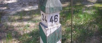
In a cultivated forest, clearings are cut along the lines: north-south, east-west. On the post at the intersections of the squares in the upper part of the number - the numbering of the opposite square.
The edge of the pillar between the two faces with the smallest numbers shows the direction to the north. The numbering of blocks in the CIS goes from west to east and further to the south.
In large tracts of cultivated forest, the sides of the horizon can be determined by the clearings, which, as a rule, are cut strictly along the north-south and east-west lines, as well as by the inscriptions of block numbers on poles installed at the intersections of the clearings. On each such pillar, in its upper part and on each of the four faces, numbers are affixed - the numbering of the opposite forest blocks; the edge between the two faces with the smallest numbers shows the direction to the north.
Correct orientation on the ground is an important skill, thanks to which you can avoid getting lost even in difficult conditions. Modern means of communication designed to solve such problems may turn out to be useless.
Domestic forests often consist of densely growing trees. They can stretch for several kilometers. In such a situation, correct orientation based on local signs can help out.
It's not just running
“You need to be a super strong runner to orienteer...” is one of the most common excuses I hear for not trying this sport. And the answer to this will be my big, thick and resounding “no.” Of course, if you want to win events, you need to be strong physically, and elite orienteers are some of the most highly trained athletes in running. But lack of good physical shape is not an obstacle to orienteering. Many beginning athletes (regardless of age) cover their first distances in orienteering on foot. And this is the best way to learn proper navigation skills. In addition, there are four disciplines of orienteering: running, cycling, skiing and trail orienteering (for people with disabilities). Everyone can choose something for themselves.
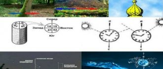
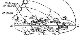
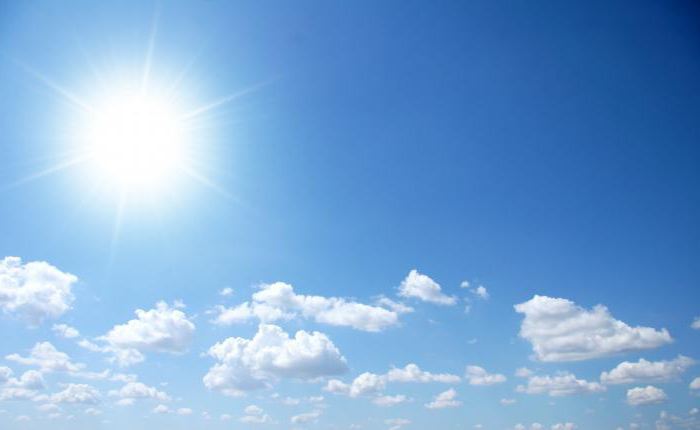
Orientation by the Sun
You may know that its rising and setting locations vary depending on the time of year. The sun rises in the southeast in winter and sets in the southwest. In summer, it rises in the northeast and sets in the northwest. In autumn and spring, the Sun rises in the east and sets in the west. It must be remembered that at noon it is always located towards the south, regardless of the time of year. At 13 o'clock the shortest shadow from objects is observed. At this time, its direction from objects located vertically points to the north. If the Sun is hidden by clouds, you can put a knife on your fingernail. A shadow will appear, at least a small one, and it will be clear where it is.
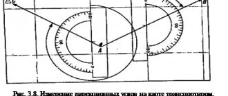
TECHNIQUES OF DRAFTING A DIAGRAM AND THE CONCEPT OF EYE SHOOTING
A diagram is a drawing of the area drawn up from a map or directly from nature. The diagram is created either by changing the scale of the map or by maintaining it. In the first case, a grid is applied to the map every 1 cm or finer; a similar enlarged grid is built on a sheet of paper, into each square of which the contents of the corresponding square of the map are redrawn. In order not to confuse the squares, the same digital and letter designations are placed on the map and diagram.
When drawing up a diagram, it is convenient to use a wedge scale. It is a right triangle drawn on graph paper or checkered paper; one leg of the triangle is a segment depicting the length of the line on a map scale, for example 1: 50000, and the other is the same length, but on the scale of the diagram being drawn up, for example 1: 100000. If the diagram is drawn up on a map scale, it is convenient to redraw it on glass, illuminated from below by an electric lamp, or on window glass.
In some cases, it may be necessary to draw a diagram or outlines of a separate section on the ground (a outline is a drawing of the area compiled by eye survey methods for a specific purpose, for example, a ford outline).
For visual surveying, you need a blank sheet of paper on a hard backing (tablet), a compass, a sight line, a pencil, an eraser and a step scale built on a strip of paper, which allows the distances measured in steps to be plotted directly in meters.
When shooting, the tablet should always be oriented towards the horizon. SY is drawn on the tablet
on which the compass is fixed with a zero diameter and rotated until the arrow aligns with the line N.S. The starting point of shooting is selected so that the area being photographed is located on the tablet. Filming is carried out from walking lines. The distances to the objects being photographed are determined by eye, with notches and steps. The length of walking lines is measured in steps. The direction towards objects is determined by sighting them using a sight line.
Below is an example of constructing a step scale for visual surveying of 1: 10,000, where 1 cm corresponds to 100 m, or 63 pairs of steps.
Taking 1.5 cm as the base, we construct a scale, as shown in Fig. 38.
Eye survey is quite labor-intensive and requires certain skills. If possible, it is more advisable to replace it with sketches and photographs of the area.
Finding your location
The essence of orientation is to determine your location relative to the sides of the horizon, landforms, and surrounding objects. Orientation is carried out using a compass, local objects, landforms, the sun, moon, stars, etc. To correctly navigate the terrain, you need to learn:
- read the map;
- find the cardinal directions without a compass;
- identify surrounding local objects (identify landmarks);
- recognize bodies of water, trails, relief details (lowlands, ravines, elevations);
- measure distances.
Relief details and local objects, relative to which the location of an object is determined, serve as landmarks. Location orientation is carried out:
- Using a topographic map. To do this, you need to lay out the map in accordance with the cardinal directions and determine your standing point.
- Without a map. You can determine the cardinal directions by surrounding objects, natural signs, the Moon and a clock, the Sun and a clock, by a compass, and find your location using designated landmarks.
Determine your standing point using any of the following methods.
By nearby landmarks, by eye
This is a fairly simple and therefore the main way to approximately determine your location. The topographic map must be laid out in a horizontal plane so that all directions indicated on it correspond to the sides of the horizon and 1-2 landmarks must be identified on it.
Being near any noticeable landmarks, determining your location is as easy as shelling pears. The functions of the main landmark can be assigned to a bridge, large stone, intersection, etc. marked on the map. The location of this symbol will become the desired point that needs to be plotted on the map.
Example: while stopping in an open area, a tree was discovered growing straight in the direction the group was moving forward, and a little to the left, at a right angle, a turning pole. The distance to the tree (400 m) and to the pole (200 m), determined by eye, is marked on the map so that a right angle is formed between them.
Measuring the path taken
This method is applicable when moving along a path, clearing, road or other terrain line marked on the map (lake shore, forest edge, etc.). The measurement is also used when moving in a straight line in the chosen direction (alternatively, to a distant landmark or in poor visibility conditions - in a given direction).
This method is indispensable in closed areas with poor landmarks. You should start moving from any symbol identified on the ground and marked on the map (bridge, intersection, forest edge) and count your steps in pairs. Thus, to determine the standing point, it is enough to plot on the map scale the distance traveled from the starting point in a given direction.
Serif according to landmarks
In open areas or when visibility is good, there is no better way to determine your location. While moving along any linear landmark, you need to identify on the map any symbol visible on the ground (tree, stone, pillar, etc.).
Attaching a pencil to the image, rotate it around the landmark so that the orientation of the map does not go astray. The intersection point of an imaginary line running parallel to a pencil depicting the road on which the object is located will become the point of its location.
If the selected landmark is located perpendicular to the route, or on the same line with another landmark visible and marked on the map, determining the location is easy.
In the first case, this is the point of intersection of the road with a straight line laid through a landmark (perpendicular to the route of the object). In the second - with a straight line passing through both landmarks.
Resection by several landmarks (Bolotov method)
Applies if the hiking trip takes place away from roads and in directions not indicated on the map. The main thing is to find on the ground two objects indicated on the map, located in different directions, at an angle of 30 to 150 degrees from each other.
Then orient the map according to the compass and, having marked the landmarks on it, draw straight lines from them towards you. The intersection of these directions will become the desired point.