Orientation by the Sun
Navigation requires knowledge of a large number of nuances. There are many ways to identify cardinal directions.
Objects in the sky that can give a clue are:
- Sun;
- Moon;
- stars.
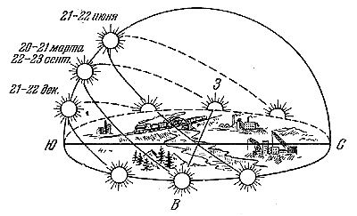
Navigating the area without a map involves a careful study of natural features depending on a particular time of year. Depending on the season, the location of sunrise and sunset may vary. In winter, sunrise is in the southeast and sunset is in the southwest. In summer, sunrise is northeast, sunset is northwest, respectively.
The smallest shadow from objects located on the ground is observed at true solar noon (for us it is 13 hours). In the case of vertically directed objects, the shadow will fall towards the north.
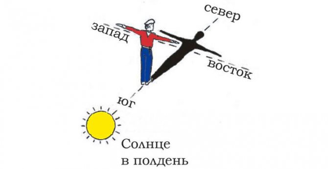
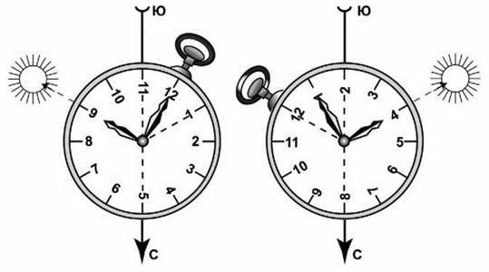
To determine the localization by the sun and the clock, you need to point the hour hand at the celestial body. As a result, an angle is formed between the arrow and true solar noon. It should be roughly divided in half. The line formed will show that the south is ahead and the north is behind.
By compass
There are situations when you need to find out your location and find your way, but the road is unknown, and you only have a compass with you. This is not scary, because it is possible to find your way without a map.
- First of all, you need to choose a landmark, which can be a clear object, preferably with a certain length, for example, a river, a road or railway, a high hill.
- After identifying a landmark, you need to move away from it in a perpendicular direction, but leaving it visible to you.
- Stand facing the reference object and put the compass into operation. Turn it until the index arrow is parallel to the zero scale, that is, until they coincide.
- Mentally draw a straight line along the center of the compass to the landmark. We fix the azimuth of the return, the reverse side of the line will show the direction of movement.
- During the journey, you need to constantly monitor so as not to deviate from the direction chosen by the compass.
- Read more about how to navigate with and without a compass on our website.
Compass
Following this action plan, you can design an entire route consisting of landmarks, the main thing is to record the azimuth values. If you return, you will need to turn forward, put the compass in such a position that the front sight pointer points forward, and turn around with it so that the north of the arrow coincides with the north of the scale. After that, continue straight ahead.
We recommend reading:
How to light a fire without matches
Using the compass near metal accumulations, railways or thunderstorms is not advisable, as the data will be distorted at this time. Additionally, it is not recommended to rely on compass data near power lines.
Such restrictions are due to the fact that the compass reacts to the magnetic field, and near metal it will be overestimated and the arrow of the orientation device will only lead astray from the desired path, as it will deviate towards the accumulation of metal objects.
By the North Star
Determining your own location and correct orientation based on basic natural features may seem like a difficult task if a person is used to using a GPS tracker and compass. But if desired, even a child can learn to apply this set of rules.
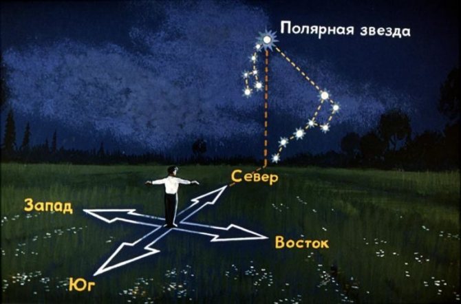
Polaris is traditionally located in the northern part of the sky . To discover it, you need to find the constellation Ursa Major. It is similar in shape to a ladle, which is formed by 7 stars. If you draw an imaginary line through 2 of them, located on the right edge, you will be able to detect the North Star. It is located in the tail part of another celestial object - Ursa Minor. By facing this star, you will be able to find out where north is.
Forest clearings
If a lost person comes across a clearing, he will be very lucky. Determining the direction in this case will not be difficult. Orientation based on local characteristics in this case is very easy to carry out. The fact is that in forestry there is a custom of dividing the taiga into quarters. This is why clearings are cut. They go from west to east and from north to south. Quarter poles are installed at intersections. Their upper part is trimmed in a characteristic way: in the form of edges. They indicate the number of opposite blocks. Number 1 is installed in the northwest corner, the last one in the southeast. In order not to look for the starting post, you should remember a simple rule: the angle between the 2 smallest numbers will indicate the direction to the north.
However, there is an exception to this rule: in rare cases, clearings are cut without reference to the sides of the horizon. As a rule, this is facilitated by difficult terrain or some economic considerations.
Determining cardinal directions by the moon
The table shows the location of the moon depending on its phase and time.
| Moon phases | Part of the disk | 19:00 | 1:00 | 7:00 |
| First quarter |