Methods for determining distances on the ground and target designation
Methods for determining distances on the ground
Very often it is necessary to determine the distances to various objects on the ground. Distances are most accurately and quickly determined using special instruments (rangefinders) and rangefinder scales of binoculars, stereo scopes, and sights. But due to the lack of instruments, distances are often determined using improvised means and by eye.
Common methods for determining the range (distances) to objects on the ground include the following: by the angular dimensions of the object; by linear dimensions of objects; eye; by visibility (discernibility) of objects; by sound, etc.
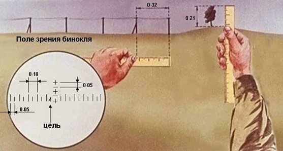
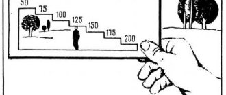
Rice. 8. Determination of distances by the angular dimensions of an object (subject)
Determination of distances by the angular dimensions of objects (Fig. is based on the relationship between angular and linear quantities. The angular dimensions of objects are measured in thousandths using binoculars, observation and aiming devices, a ruler, etc.
Some angular values (in thousandths of the distance) are given in Table 2.
table 2
| Name of items | Size in thousandths |
| Thumb thickness | 40 |
| Index finger thickness | 33 |
| Middle finger thickness | 35 |
| Little finger thickness | 25 |
| Cartridge along the width of the case neck (7.62 mm) | 12 |
| Sleeve 7.62 mm across body width | 18 |
| Simple pencil | 10-11 |
| Matchbox length | 60 |
| Matchbox width | 50 |
| Matchbox height | 30 |
| Match thickness | 2 |
The distance to objects in meters is determined by the formula: , where B is the height (width) of the object in meters; Y is the angular magnitude of the object in thousandths.
For example (see Fig. 8): 1) the angular size of a landmark observed through binoculars (a telegraph pole with a support), the height of which is 6 m, is equal to the small division of the binocular reticle (0-05). Therefore, the distance to the landmark will be equal to: .
2) the angle in thousandths, measured with a ruler located at a distance of 50 cm from the eye, (1 mm is equal to 0-02) between two telegraph poles 0-32 (telegraph poles are located at a distance of 50 m from each other). Therefore, the distance to the landmark will be equal to: .
3) tree height in thousandths, measured with a 0-21 ruler (true tree height 6 m). Therefore, the distance to the landmark will be equal to: .
Determining distances based on the linear dimensions of objects is as follows (Fig. 9). Using a ruler located at a distance of 50 cm from the eye, measure the height (width) of the observed object in millimeters. Then the actual height (width) of the object in centimeters is divided by that measured by a ruler in millimeters, the result is multiplied by a constant number 5 and the desired height of the object in meters is obtained.
Rice. 9. Determination of distances by linear dimensions of an object (subject)
For example, a distance between telegraph poles equal to 50 m (Fig. 8) is closed on the ruler by a segment of 10 mm. Therefore, the distance to the telegraph line is:
The accuracy of determining distances by angular and linear values is 5-10% of the length of the measured distance. To determine distances based on the angular and linear dimensions of objects, it is recommended to remember the values (width, height, length) of some of them, given in table. 3.
Table 3
| Item | Dimensions, m | ||
| Height | Length | Width | |
| Medium tank | 2-2,5 | 6-7 | 3-3 5 |
| Armored personnel carrier | 2 | 5-6 | 2-2,4 |
| Motorcycle with sidecar | 1 | 2 | 1,2 |
| Freight car | 2-2,5 | 5-6 | 2-3,5 |
| A car | 1,6 | 4 | 1,5 |
| Four-axle passenger car | 4 | 20 | 3 |
| Four-axle railway tank | 3 | 9 | 2,8 |
| Wooden communication line pole | 5-7 | — | — |
| Average height man | 1,7 | — | — |
Determining distances by eye
The eye method is the easiest and fastest way. The main thing in it is the training of visual memory and the ability to mentally lay down on the ground a well-imagined constant measure (50, 100, 200, 500 meters). Having fixed these standards in memory, it is not difficult to compare with them and estimate distances on the ground.
When measuring distance by successively mentally setting aside a well-studied constant measure, one must remember that the terrain and local objects seem reduced in accordance with their distance, that is, when removed by half, the object will seem half as large. Therefore, when measuring distances, the mentally plotted segments (measures of terrain) will decrease according to the distance.
In this case, it is necessary to take into account the following: - the closer the distance, the clearer and sharper the visible object seems to us; - the closer the object, the larger it seems; - larger objects seem closer than small objects located at the same distance; - an object of a brighter color seems closer than an object of a dark color; - brightly lit objects seem closer to dimly lit ones that are at the same distance; - during fog, rain, twilight, cloudy days, when the air is saturated with dust, the observed objects seem further away than on clear and sunny days; - the sharper the difference in the color of the object and the background against which it is visible, the more reduced the distances seem; for example, in winter a snow field seems to bring the darker objects on it closer; - objects on flat terrain seem closer than on hilly terrain, distances defined across vast expanses of water seem especially shortened; — folds of the terrain (river valleys, depressions, ravines), invisible or not fully visible to the observer, conceal the distance; - when observing while lying down, objects seem closer than when observing while standing; - when observed from bottom to top - from the base of the mountain to the top, objects seem closer, and when observed from top to bottom - further; - when the sun is behind the soldier, the distance disappears; shines into the eyes - it seems larger than in reality; - the fewer objects there are in the area under consideration (when observed through a body of water, a flat meadow, steppe, arable land), the smaller the distances seem.
The accuracy of the eye meter depends on the training of the soldier. For a distance of 1000 m, the usual error ranges from 10-20%.
Determination of distances by visibility (discernibility) of objects
With the naked eye, you can approximately determine the distance to targets (objects) by the degree of their visibility. A soldier with normal visual acuity can see and distinguish some objects from the following maximum distances indicated in Table 4.
It must be borne in mind that the table indicates the maximum distances from which certain objects begin to be visible. For example, if a serviceman saw a pipe on the roof of a house, this means that the house is no more than 3 km away, and not exactly 3 km. It is not recommended to use this table as a reference. Each serviceman must individually clarify this data for himself.
Table 4
| Objects and attributes | Distances from which they become visible (discernible) |
| Separate small house, hut | 5 km |
| Pipe on the roof | 3 km |
| Airplane on the ground tank in place | 1 2 km |
| Tree trunks, kilometer poles and communication line poles | 1.0 km |
| Movement of the legs and arms of a running or walking person | 700 m |
| Heavy machine gun, mortar, anti-tank gun, wire fence stakes | 500 m |
| Light machine gun, rifle, color and parts of clothing on a man, the oval of his face | 250 – 300 m |
| Roof tiles, tree leaves, wire on stakes | 200 m |
| Buttons and buckles, details of a soldier's weapons | 100 m |
| Human facial features, hands, details of small arms | 100 m |
Orientation by sounds
At night and in fog, when observation is limited or impossible at all (and in very rough terrain and in the forest, both at night and during the day), hearing comes to the aid of vision.
Military personnel must learn to determine the nature of sounds (that is, what they mean), the distance to the sources of sounds and the direction from which they come. If different sounds are heard, the soldier must be able to distinguish them from one another. The development of such an ability is achieved through long-term training (in the same way a professional musician distinguishes the voices of instruments in an orchestra).
Almost all sounds that indicate danger are made by humans. Therefore, if a soldier hears even the faintest suspicious noise, he should freeze in place and listen. If the enemy starts moving first, thereby giving away his location, then he will be the first to be detected.
On a quiet summer night, even an ordinary human voice in an open space can be heard far away, sometimes half a kilometer. On a frosty autumn or winter night, all kinds of sounds and noises can be heard very far away. This applies to speech, steps, and the clinking of dishes or weapons. In foggy weather, sounds can also be heard far away, but their direction is difficult to determine. On the surface of calm water and in the forest, when there is no wind, sounds travel a very long distance. But the rain greatly muffles the sounds. The wind blowing towards the soldier brings sounds closer and away from him. It also carries sound away, creating a distorted picture of the location of its source. Mountains, forests, buildings, ravines, gorges and deep hollows change the direction of sound, creating an echo. They also generate echoes and water spaces, facilitating its spread over long distances.
The sound changes when its source moves on soft, wet or hard soil, along the street, along a country or field road, on pavement or soil covered with leaves. It must be taken into account that dry soil transmits sounds better than air. At night, sounds are transmitted especially well through the ground. That’s why they often listen by putting their ears to the ground or tree trunks. The average range of audibility of various sounds during the day on flat terrain, km (in summer), is given in Table 5.
Table 5
| Character of sound | Hearing range, m |
| The crack of a broken branch | Up to 80 |
| Steps of a man walking along the road | 40-100 |
| Strike the oars on the water | Up to 1000 |
| The blow of an ax, the ringing of a cross-saw | 300-400 |
| Digging trenches with shovels in hard ground | 500-1000 |
| Quiet conversation | 200-300 |
| Shout | 1000-1500 |
| The sound of metal parts of equipment | Up to 300 |
| Loading small arms | Up to 500 |
| Tank engine running on site | Up to 1000 |
| Movement of troops on foot: | |
| - on a dirt road | Up to 300 |
| - along the highway | Up to 600 |
| Vehicle movement: | |
| - on a dirt road | Up to 500 |
| - along the highway | Up to 1000 |
| Tank movement: | |
| - on a dirt road | Up to 1200 |
| - along the highway | 3000-4000 |
| Shot: | |
| - from a rifle | 2000-3000 |
| - from a gun | 5000 or more |
| Gun firing | Up to 15000 |
To listen to sounds while lying down, you need to lie on your stomach and listen while lying down, trying to determine the direction of the sounds. This is easier to do by turning one ear in the direction from which the suspicious noise is coming. To improve hearing, it is recommended to apply bent palms, a bowler hat, or a piece of pipe to the auricle.
To better listen to sounds, you can put your ear to a dry board placed on the ground, which acts as a sound collector, or to a dry log dug into the ground.
Determining distances using the speedometer. The distance traveled by a car is determined as the difference between the speedometer readings at the beginning and end of the journey. When driving on hard-surfaced roads it will be 3-5%, and on viscous soil 8-12% more than the actual distance. Such errors in determining distances using the speedometer arise from wheel slip (track slippage), tire tread wear and changes in tire pressure. If you need to determine the distance traveled by the car as accurately as possible, you need to make an amendment to the speedometer readings. This need arises, for example, when moving in azimuth or when orienting using navigation devices.
The amount of correction is determined before the march. For this purpose, a section of the road is selected, which in terms of the nature of the relief and soil cover is similar to the upcoming route. This section is passed at marching speed in the forward and reverse directions, taking speedometer readings at the beginning and end of the section. Based on the data obtained, the average length of the control section is determined and the value of the same section, determined from a map or on the ground with a tape (roulette), is subtracted from it. Dividing the result obtained by the length of the section measured on the map (on the ground) and multiplying by 100, the correction factor is obtained.
For example, if the average value of the control section is 4.2 km, and the measured value on the map is 3.8 km, then the correction factor is:
Thus, if the length of the route measured on the map is 50 km, then the speedometer will read 55 km, i.e. 10% more. The difference of 5 km is the magnitude of the correction. In some cases it may be negative.
Measuring distances in steps . This method is usually used when moving in azimuth, drawing up terrain diagrams, drawing individual objects and landmarks on a map (scheme), and in other cases. Steps are usually counted in pairs. When measuring a long distance, it is more convenient to count steps in threes, alternately under the left and right foot. After every hundred pairs or triplets of steps, a mark is made in some way and the countdown begins again.
When converting the measured distance in steps into meters, the number of pairs or triplets of steps is multiplied by the length of one pair or triple of steps.
For example, there are 254 pairs of steps taken between turning points on the route. The length of one pair of steps is 1.6 m. Then
Typically, the step of a person of average height is 0.7-0.8 m. The length of your step can be determined quite accurately using the formula: , where D is the length of one step in meters; P is a person’s height in meters.
For example, if a person is 1.72 m tall, then his step length will be equal to:
More precisely, the step length is determined by measuring some flat linear section of terrain, for example a road, with a length of 200-300 m, which is measured in advance with a measuring tape (tape measure, range finder, etc.).
When measuring distances approximately, the length of a pair of steps is taken to be 1.5 m.
The average error in measuring distances in steps, depending on driving conditions, is about 2-5% of the distance traveled.
Determination of distance by time and speed. This method is used to approximate the distance traveled, for which the average speed is multiplied by the time of movement. The average walking speed is about 5, and when skiing 8-10 km/h.
For example, if a reconnaissance patrol skied for 3 hours, then it covered about 30 km.
Determination of distances by the ratio of the speeds of sound and light. Sound travels in the air at a speed of 330 m/s, i.e. approximately 1 km per 3 s, and light travels almost instantly (300,000 km/h). Thus, the distance in kilometers to the place of the flash of the shot (explosion) is equal to the number of seconds that passed from the moment of the flash to the moment when the sound of the shot (explosion) was heard, divided by 3.
For example, an observer heard the sound of an explosion 11 seconds after the flash. The distance to the flash point will be:
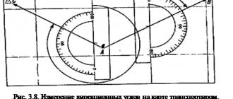
Determination of distances by geometric constructions on the ground . This method can be used to determine the width of difficult or impassable terrain and obstacles (rivers, lakes, flooded areas, etc.). Figure 10 shows the determination of the river width by constructing an isosceles triangle on the ground.
Since in such a triangle the legs are equal, the width of the river AB is equal to the length of the leg AC.
Point A is selected on the ground so that a local object (point B) on the opposite bank can be seen from it, and a distance equal to its width can be measured along the river bank.
The position of point C is found by approximation, measuring the angle ACB with a compass until its value becomes equal to 45°.
Another version of this method is shown in Fig. 10, b.
Point C is selected so that the angle ACB is equal to 60°.
It is known that the tangent of an angle of 60° is equal to 1/2, therefore, the width of the river is equal to twice the distance AC.
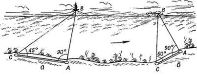
Fig. 10. Determination of distances by geometric constructions on the ground.
In both the first and second cases, the angle at point A should be equal to 90°.
Orientation by light is very convenient for maintaining direction or for determining the position of an object on the ground. Moving at night towards a light source is most reliable. The distances at which light sources can be detected by the naked eye at night are given in Table 6.
Table 6
| Light source | Detection range, km |
| Cigarette fire | 0,5-0,8 |
| Burning match | Up to 1.5 |
| Flashlight light | 1,5-2 |
| Flashes of small arms fire from individual guns | 1.5-2 to 4-5 |
| Car and tank headlights | up to 4-8 |
| Bonfire | up to 6-8 |
| Flashing light | 1,5 |
Target designation
Target designation is the ability to quickly and correctly indicate targets, landmarks and other objects on the ground. Target designation has important practical significance for controlling a unit and fire in battle. Target designation can be carried out either directly on the ground or from a map or aerial photograph.
When designating targets, the following basic requirements are observed: indicate the location of targets quickly, briefly, clearly and accurately; indicate goals in a strictly established order, using accepted units of measurement; the transmitter and the receiver must have common landmarks and firmly know their location, and have a uniform coding of the area.
Target designation on the ground is carried out from a landmark or in azimuth and range to the target, as well as by pointing the weapon at the target.
Targeting from a landmark is the most common method. First, the closest landmark to the target is named, then the angle between the direction to the landmark and the direction to the target in thousandths, and the distance of the target from the landmark in meters. For example: “Landmark two, forty-five to the right, then one hundred, there is an observer at a separate tree.”
If the transmitting and receiving target have observation devices, then instead of the distance of the target from the landmark, the vertical angle between the landmark and the target in thousandths can be indicated. For example: “Landmark four, thirty to the left, ten below - a combat vehicle in a trench.”
In some cases, especially when issuing target designation for unobtrusive targets, local objects located near the target are used. For example: “Landmark two, thirty to the right - a separate tree, further two hundred - ruins, twenty to the left, under a bush - a machine gun.”
Target designation by azimuth and range to the target
The azimuth of the direction to the appeared target is determined using a compass in degrees, and the distance to it in meters using binoculars (observation device) or by eye. Having received this data, they transmit it, for example: “Thirty-two, seven hundred - a combat vehicle.”
Target designation by pointing a weapon at a target
Targets spotted on the battlefield must be immediately reported to the commander and their location correctly indicated. The target is indicated by verbal report or tracer bullets.
The report should be short, clear and precise, for example: “There is a wide bush straight ahead, a machine gun to the left.”
“The second landmark, two fingers to the right, under the bush there is an observer.” When designating targets with tracer bullets, fire one or two short bursts in the direction of the target. Tags: military topography
By angular value
You can measure the distance with a ruler using an angular value. Let's figure out what it is and how to do it. Let's first get acquainted with the concept of a thousandth. A thousandth is an international unit of measurement of distance along the horizon, equal to 1/6 thousand of the horizon. Its use in the army is widespread, mainly for correcting shots fired.
On paper it is designated and pronounced like this:
- 1-thousandth = 0 – 01 (zero, zero one);
- 5 thousandths = 0 – 05 (like zero, zero five);
- 10 thousandths = 0 – 10 (zero, ten);
- 150 thousandths = 1 – 50 (one, fifty);
- 1500 thousandths = 15 – 00 (fifteen, zero zero).
It is possible to use this value to measure the distance to an object if you know one of the parameters of the intended landmark: width or height. A formula is used for the calculation.
- D = (Bx1000) / Y, where;
- D – distance to the object;
- B – width or height of the object in meters;
- Y – angular value in thousandths.
Got it? More or less. There are no questions with the formula, but how to find the angular value? This is where the good old school ruler comes to our rescue. Let's explain:
- take it and extend your hand with it forward 50 cm, holding the ruler strictly in a vertical position;
- we count the number of millimeters that visually constitutes the width or height of a distant landmark;
- We multiply the result by 2, because if all conditions are met correctly, 1 mm is equal to 2 thousandths (0 - 02) and substitute the resulting value into the formula.
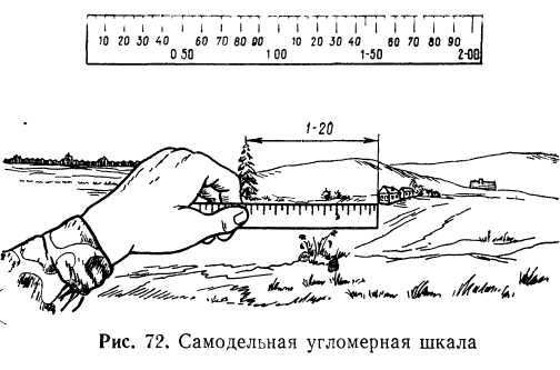
Goniometer scale
Let's look at an example. The height of a 10-story building is 30 meters. On a ruler this value is 20 mm or 40 thousandths. We substitute it into the formula and this is what we get.
- D=(30*1000)/40=750.
- Answer: 750 meters is the distance to a 10-story building.
What if the object is not tall, but we still see it? Then we use another formula.
- L = (W / number of millimeters on the ruler) x 5.
- D = the same distance to the object.
- W=height or width in centimeters.