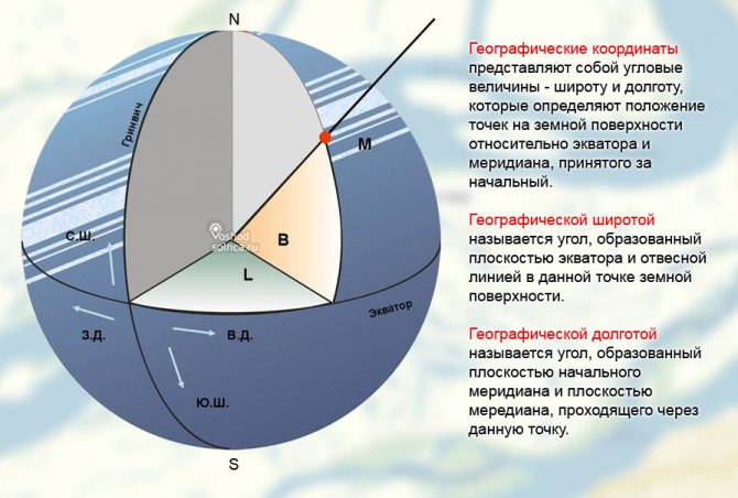
What does latitude mean?
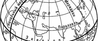
The number responsible for the latitude of a place on the map indicates its distance relative to the equator - the further the point is from it and the closer to the pole, the more its digital value increases.
- On flat images, as well as globes, latitude is determined by spherical lines drawn horizontally and parallel to the equator - parallels.
- At the equator there is a zero parallel, towards the poles the value in numbers increases.
- Parallel arcs are designated in degrees, minutes, seconds, as angular measurements.
- From the equator towards the north pole, the value will have positive values from 0º to 90º, indicated by the symbols “n.l.”, that is, “northern latitude”.
- And from the equator towards the south - negative, from 0º to -90º, indicated by the symbols “southern latitude”, that is, “southern latitude”.
- The values 90º and -90º are at the peak of the poles.
- Latitudes close to the equator are called “low”, and those close to the poles are called “high”.
Expert opinion
Makarov Igor Tarasovich
Hunter and fisherman with 20 years of experience. Wildlife lover
To determine the location of the required object relative to the equator, you just need to correlate its point with the nearest parallel, and then look at what number is opposite it to the left and right behind the map field.
- If the point is located between the lines, you must first determine the nearest parallel.
- If it is north of the desired point, then the coordinate of the point will be smaller, so from the nearest horizontal arc you need to subtract the difference in degrees to the object.
- If the nearest parallel is below the desired point, then the difference in degrees is added to its value, since the desired point will have a larger value.
This is interesting: Symbols for topographic plans and regulatory documentation
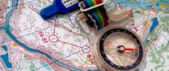
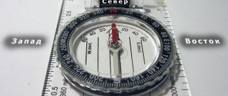
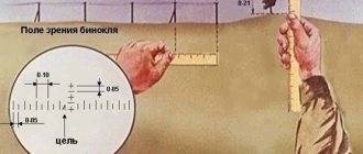
Since it is sometimes difficult to determine latitude and longitude on a map at a glance, they use a ruler with a pencil or compass.
Remember! All points on the globe, and accordingly on a map or globe, located along one parallel arc will have the same value in degrees.
What is longitude?
To find out the location of an object, it is not enough to know this place on the globe relative to the south or north. In addition to latitude, longitude is used for the full calculation, establishing the position of a point relative to east and west. If in the case of latitude the equator is taken as a basis, then longitude is calculated from the prime meridian (Greenwich), passing from the North to the South Pole through the London Borough of Greenwich.
On the right and left sides of the Greenwich meridian, ordinary meridians are drawn parallel to it, which meet each other at the poles. Eastern longitude is considered positive, and western longitude is negative.
Like latitude, longitude has 360 degrees, divided into seconds and minutes. To the east of Greenwich is Eurasia, to the west are South and North America.
How to find the coordinates of the desired point
The question often arises of how to determine latitude and longitude on a map if the desired point, distant from the coordinate grid, is located inside a square.
Calculating coordinates is also difficult when the image of the area is on a huge scale, and you don’t have more detailed information with you.
- Here you cannot do without special calculations - you will need a ruler with a pencil or a compass.
- First, the nearest parallel and meridian are determined.
- Their digital designation is recorded, then the step.
- Next, the distance from each of the arcs is measured in millimeters, then converted to kilometers using a scale.
- All this correlates with the pitch of parallels, as well as the pitch of meridians drawn on a certain scale.
- There are images with different pitches - 15º, 10º, and there are less than 4º, this directly depends on the scale.
- Having found out the distance between the nearest arcs, also the value in degrees, you need to calculate the difference, by how many degrees a given point is deviated from the coordinate grid.
- Parallel - if the object is in the northern hemisphere, then we add the resulting difference to the smaller number, and subtract it from the larger one; for the southern hemisphere, this rule works similarly, only we carry out the calculations as with positive numbers, but the final number will be negative.
- Meridian - the position of a given point in the eastern or western hemisphere does not affect the calculations; we add our calculations to the smaller value of the parallel, and subtract from the larger value.
Using a compass is also easy to calculate a geographic location - to get the value of the parallel, its ends need to be placed on the point of the desired object and the nearest horizontal arc, and then the thrust of the compass must be transferred to the scale of the existing map. And to find out the size of the meridian, repeat all this with the nearest vertical arc.
We suggest using a similar service from Yandex - find coordinates
Relationship between rectangular coordinates and other systems for marking points on the map
In addition to the direct use of the rectangular or Gaussian system, there is often a need to compare data in the specified system and on a regular geographic map. In such cases, several methods are used:
- A method for converting a value from a numeric value to standard values (latitude and longitude).
- Method for applying distance values to scale.
- A method for comparing a geographic map with an entire Gaussian zone.
Only the first method finds practical application, since it is recognized as the official way of translating the coordinates of real estate objects from a regular topographic map to a geographic one. This is the method used by government services and private specialists.
On the other hand, this is one of the most difficult methods, requiring special skills and knowledge. In addition, it is necessary to have information about key topographic points.
The simplest method is the distance imposition method. In fact, knowing the scale, even a schoolchild can calculate the coordinates using a regular ruler. However, the error in this case can be equal to tens of kilometers.
The map matching method is used extremely rarely.
For example, this method can be used when adjusting the master plan for the expansion of settlements and defining the boundaries of regions and states. But these methods allow you not only to solve private problems, but also to find out the coordinates of the desired property. This became possible after providing open access to GPS maps. Constant satellite observation of the earth's surface has made it possible to determine the location of almost any object that is not equipped with a radio-absorbing coating with an accuracy of up to a meter.
Almost anyone can find out a location by comparing data from GPS and a topographic map. To do this you need:
- obtain geographic coordinates data from the GPS system, expressed in latitude and longitude;
- using them to calculate the Gaussian zone (the median meridian in the zone);
- move the point according to the Gaussian zone.
Of course, the task is not easy, but it is doable. Another question is the official status of such a calculation.
Determining geographic coordinates - latitude and longitude on a Google Maps map (Google Maps)
Hello, dear friends of the u-karty.ru portal!
Tool - determination of geographical coordinates on a Google Maps map of a city, street, house, in real time. How to determine coordinates by address - latitude and longitude on the map, convenient search by coordinates in Google (Google Maps).
A world map with coordinates (longitude and latitude) will allow you to find any address using already known parameters, calculate the distance between two cities/points online
Fill out the Google Maps search form - enter the city, street, house number. Enter the name of any geographical feature separated by a space.
Or move the marker to the desired location yourself and search (click “Find”) using the coordinates of the object on the Google map. A similar search has already been used when searching for streets and districts in Krasnodar.
Use the change in the scale of the diagram (the desired scale will appear in the third field from the top) to take a closer look at the location of the house on the street.
As you may have noticed, when you move a label on the diagram, the geographical parameters change. We get a kind of map with latitudes and longitudes. Previously, we have already worked on determining coordinates on the Yandex map
Using the reverse method, everyone will be able to search by coordinates in Google using known parameters. Instead of the geographical name of the object, we fill out the search form with known coordinates. The service will determine and show on the map the exact geographical location of the street or area.
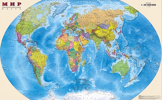
Geographic map of the world with latitude and longitude
The main characteristic that geographic maps have is the scale at which they are drawn. In general, scale is a reduction indicator that shows how many times the object depicted on the map is smaller than the real one. It is written as a mathematical ratio as 1:1000000. The larger the number on the right, the smaller the scale of the map.
Small-scale maps give only a superficial idea of the coordinates of objects on the earth's surface and the error in determining coordinates from them is about 20, which, when converted to distance, gives an error of several tens of kilometers. In addition, there is a certain difficulty in transferring the spherical shape of the Earth onto the flat surface of a paper map.
In order to get around this limitation, the world map is divided into sections limited by meridians of 40 and parallels of 60. Thus, trapezoid-shaped maps were obtained (in geography it is customary to call these maps “squares”) with a scale of 1:1000000. On this scale, 1 cm is equal to 1 km.
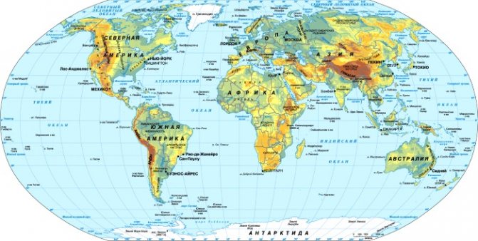
Each resulting square bears an alphanumeric designation according to the Latin alphabet from A to V. To avoid confusion, when designating squares belonging to the southern hemisphere, a small Latin letter “s” is placed before their name: from sA to sV.
To further improve the accuracy of the map, each square is divided into another 144 pieces measuring 20 by 30 minutes. They are numbered in order from left to right and top to bottom. On this scale, 1 cm is equal to 1 km. The geographic coordinates of an object, the accuracy of which requires an error of up to several meters, are determined from large-scale topographic maps.
Interesting places in Google Maps - online secrets from satellite
Knowing the address of any city in the world, the latitude and longitude of Washington and Santiago, Beijing and Moscow can be easily determined. Scheme of the city
Saratov with house and street numbers is available to both city guests and local residents. We are sure that you have already been able to master this tool on the page; by default, the map shows the center of the capital of Russia - the city of Moscow.
Find your latitude and longitude on the map at the address.
We propose to find out the secrets of the Google Maps service online. The satellite will not fly past interesting historical places, each of which is popular in a certain part of the globe.
Below you can see for yourself that these interesting places on earth deserve special attention. And the Google Maps Sputnik service is happy to offer you to find and see the most famous geographical secrets of the world. We believe that residents of the Samara region will also be interested. They already know what the Avtozavodsky district of Togliatti looks like.
You do not need to determine their geographic coordinates and search for the necessary Google maps service. Just copy any parameters from the list below - latitude and longitude (CTRL+C).
For example, we will watch from a satellite (switch to the “Satellite” scheme type) the largest stadium in the world and Brazil - Maracana (Rio de Janeiro, Maracana). Copy the latitude and longitude from the list below:
Paste it into the search form of the Google Maps service (CTRL+V). All that remains is to start the search for the object itself. A mark with the exact location of the coordinates will appear on the diagram. We remind you that you must activate the “Satellite” scheme type. Everyone will choose a scale +/- that is convenient for themselves in order to better see the stadium in Brazil
Save to bookmarks in any browser - CTRL+D
We invite you to share the list with your friends!
Thank you to Google Maps for the data you provided.
How to tell time
Currently, all settlements live in the time that corresponds to their time zone. If people were guided strictly by solar time, then the world would be in chaos and confusion. All settlements located within the same time zone have the same time on their clocks. Moreover, in Russia the rule of maternity time has long been in force (for example, orientation according to Moscow time). This principle has been actively applied everywhere since 1960. It consists in the fact that all clocks are moved forward 1 hour. Thus, if it is 12 o’clock in Moscow, then the time of the 30th meridian will be calculated as 12-1 = 11 o’clock. Now, knowing real and meridian time, you can easily determine geographic longitude. To do this, it is enough to know the real time (corresponding to the time zone) and the time of the 30th meridian.
In particular, if the meridian time is 11 o'clock and the real time is 11:20, then the longitude can be calculated. Scientists have proven that the Earth rotates 1 degree every 4 minutes. Consequently, the populated area will be located 5 degrees east of the 30th meridian, and the level of geographic longitude will be 35 degrees east.
Geographical position
Geographical location is associated with several fundamental definitions - a geographical object, a geospatial relationship, elements of the external environment, etc. In a general sense, the definition of a geographical location, its establishment, the analysis of interactions and connections between individual geographical objects - this is the fundamental task of geography.
It was in the process of development of this science that the concept of geographic location as an individual factor of a geographical object was born. This is important historically, because
is associated with the definition of the territory and boundaries of a geographical object and its basic properties.
The definition of geographical location is dealt with by theoretical geography, which uses the principle of the positional approach, meaning that the properties of a geographical object depend on its geographical location. In addition, theoretical geography also takes into account the principle of positional pressure, according to which a geographical object can move under the influence of external factors and objective reasons.
In a narrower sense, the definition of geographic location is the determination of geographic coordinates and cardinal directions. This is an important applied task, the solution of which is important for the successful performance of functions in various fields of activity. In a practical sense, its solution comes down to determining geographic longitude and latitude.
This is interesting: How to choose and where to buy hunting and fishing skis.
Geographical coordinates
- Determination of geographic longitude
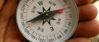
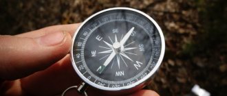
You can determine geographic longitude and the direction of the cardinal points in the simplest way using a gnomon (an ordinary stick), a clock and a calendar with a table of corrections. The shortest shadow from the gnomon indicates the onset of local noon (and it will be directed strictly from south to north).
Expert opinion
Makarov Igor Tarasovich
Hunter and fisherman with 20 years of experience. Wildlife lover
It is necessary to note the time on the clock, convert it to Greenwich time and use the table to convert it to local average. After this, the difference between geographic noon is 12 hours.
– and the resulting result must be converted into degrees. This will be the geographic longitude.
- Determination of geographic latitude
There are several ways to determine geographic latitude.
The simplest is to determine the angle between the North Star and the horizon. Previously, sailors and travelers used a special device for this - a sextant, which did this with high accuracy.
Using a simple device made from a regular protractor and a plumb line can also determine this angle, but with less accuracy. If the base of the protractor is pointed at the North Star and the angle between it and the plumb line is noted, and 90 is subtracted from the result obtained, then this figure will be the geographic latitude.
You can determine latitude by noting the length of day between sunrise and sunset. Next, the latitude is determined using a nomogram or table.
Currently, geographic coordinates are established by various electronic devices based on geopositioning and satellite navigation.
Latitude and longitude are geographic coordinates expressed in degrees that fairly accurately reflect the location of an object.
The ability to determine latitude and longitude is important in navigation, travel, and orienteering. To master it, you need to understand the structure of the degree grid plotted on the map.
|
|
|
|
|
|
|
|
|
|
|
|
|
|
|
|
|
|
|
|
Chapter 1
§ 3. Difference of latitudes and difference of longitudes
Geographic coordinates—latitude and longitude—unambiguously determine the position of a specific point on the earth’s surface. The transition from one point on the earth's surface to another is accompanied by a change in their geographical coordinates. Points lying on the same parallel have the same latitude and different longitudes. Points located on the same meridian have the same longitude and different latitudes. In general, two points that are not on the same meridian or parallel have different latitudes and different longitudes. In the practice of navigation, it is often necessary to know how geographic coordinates have changed or will change when moving from one point on the earth’s surface to another, and to be able to calculate these changes. The quantities that characterize the change in geographic coordinates when moving from one point on the earth’s surface to another are the difference in latitude and difference in longitude. The latitude difference (DL) of two points on the Earth's surface is the meridian arc enclosed between the parallels of these points. To calculate the difference in latitude, use the formula РШ = φ2 - φ1, taking into account the signs + and - according to their names. Indeed, the figure shows that the change in latitude (RL) when a ship moves from point A to point B is characterized by arc A'B, numerically equal to the difference in the arcs of the meridians of points of arrival B and departure A, determined by the latitudes φB and φA, respectively. The latitude difference calculated using formula (4) is assigned a plus sign if it is towards N, and a minus sign if the latitude difference is towards S. The latitude difference can vary from 0 to ±180°. The longitude difference (LD), which characterizes the change in longitude, as can be seen from the figure, is the central angle between the meridians of two points. This angle is measured by the arc of the equator between the indicated meridians. On this basis, the difference in longitude of two points on the surface of the Earth is called the smaller of the arcs of the equator, enclosed between the meridians of these points. From this definition it follows that the difference in longitude can have values from 0 to ±180°. Taking into account the previously adopted notations (for eastern longitude there is a plus sign and for western longitude - minus), we can write a formula for calculating the RD of two points: RD = λ2 - λ1 The longitude difference will have a plus sign if it is made to Ost, and a minus sign if it made to W. This rule has the following geometric meaning: if the meridian of the arrival point λ 2 is located east of the meridian of the departure point λ 1, then the difference in longitude is made to Ost and a plus sign is assigned to it. Conversely, when the meridian of the arrival point is located west of the departure point meridian, the difference in longitude is made to W and a minus sign is assigned to it. When solving the problem of calculating the taxiway using the formula, the result may exceed 180°. In these cases, to find the smaller of the arcs of the equator, the result obtained should be subtracted from 360° and its sign (name) should be reversed.
Example 1.
Find the taxiways of two points with longitudes λ2 = 164°15'Ost and λ1 = 147°28'W.
Solution.
λ2 = + 64°15′ - λ1 = - 147°28′ ____________________ RD = + 311°43′ We find the addition to 360° and change the sign: RD = - 48°17′ = 48°17'k W.
It is recommended to accompany calculations of RS and RD using the given formulas by constructing a drawing, which, in addition to monitoring the correctness of the solution, develops spatial imagination.
Example 2. The ship moved from a point with coordinates φ1 = 59°50'N and λ1 = 26°30'0st to a destination with coordinates φ2 = 54°44'N and λ2 =19°42'Ost. Find the RS and RS performed by the ship during the passage.
Solution. Illustrating the example with the help of a drawing, let us schematically depict on the surface of the ball the starting and ending points of the ship’s transition according to their given coordinates. It can be seen from the figure that during the transition the ship decreased its northern latitude and eastern longitude, therefore, the RS is made to S, and the taxiway - to W. We will find the numerical value of the RS and taxiway using the formulas
φ2 = + 54°44′ — φ1 = + 59°50′ __________________________ РШ = — 5°06′ or РШ=5°06 to S. | λ2 = + 19°42′ – λ1 = + 26°30′ ____________________ RD = – 6°48′ or RD = 6°48′ to W. |
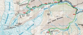
Determine the coordinates of a point on the map - with video
To calculate the geographic coordinates of an object, you need:
- Determine its geographic latitude
- Determine its geographic longitude.
- Combine latitude with longitude.
For example, Vladivostok is located north of the equator at the 43rd parallel and east of Greenwich at the 132nd meridian, which means its coordinates are 43 ° N. w. and 132°E. d.
In order to determine the coordinates of smaller objects, you need a detailed map where you can operate not only in degrees, but also in minutes and seconds. Detailing coordinates down to geographic seconds specifies the location of an object with an accuracy of up to 30 meters.
There is usually a scale bar in the corner of the map, which indicates the ratio of distances on the map to distances in geographic coordinates and kilometers.
Then, by applying an ordinary millimeter ruler to a scale ruler, you can find out that, for example, 1° of latitude is equal to 30 mm, 1° of longitude is 40 mm. Then, using simple measurements on the map and mathematical proportions, it is easy to calculate the exact coordinates.
If calculations are required on a hike, it is better to practice at home in advance.
Video example of determining coordinates on a topographic map
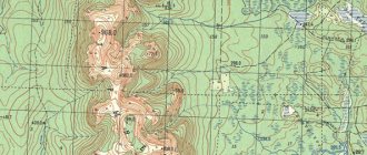
Determining rectangular coordinates on a topographic map
To determine the coordinates of points on maps, it is very important to have landmarks. If the initial coordinates are clear and you just need to indicate them on the map, then this is done as follows:
- A square is determined on the grid based on kilometer coordinates.
- Using a ruler, meter values are measured inside the square, first along a parallel line to the abscissa axis, then to the ordinate axis.
- Meter values are indicated along the lines.
In general, the procedure is completed. However, in practice it is not so simple. Often there is no value for the original coordinates. In such cases, it is important to have certain landmarks, without which it seems impossible to find the point. Any nearby point with known coordinates can serve as a landmark. It is enough to find out the real distance between the known point and the desired object.
It is impossible to indicate the address of a point on the map 100% accurately, so approximate values are determined.
On the other hand, modern technologies make it possible to make accurate measurements on site with instant display of the results on an electronic topographic map.
For this purpose, laser measurement or radar methods are used. In any case, if there is a practical need to find out the location of a particular property, the right decision would be to turn to specialists. The following may act as specialists:
- engineers of the state service of geodesy and cartography (cadastre);
- specialists from private engineering services.
At the same time, private engineering services have at their disposal more high-tech, and therefore more accurate, equipment than government agencies. Of course, the services of such specialists are not cheap.
We recommend that you read:
Symbols on topographic maps
Determining latitude and longitude on online maps Google and Yandex
To determine coordinates in online maps, Google and Yandex use two main options.
- Using the search form. Enter the name of the object (country, city, street, house number) into the field and press “find”. In the Yandex service, coordinates appear in the window on the left under the address. In the Google service, you need to click on the red mark and select the line “What’s here” in the context menu; the coordinates will appear in the drop-down window. The same line is in the Yandex context menu, in case the data window does not appear automatically.
- Drag a label. A geolocation tag is manually placed on the desired object. At the same time, they use navigation and zoom tools for searching (zoom out, zoom in, scroll through the map). Viewing coordinates is similar to the previous point.
If you need to determine your own exact coordinates, but the name of the area and the exact location are unknown, then you must give permission to the application to track your geolocation.
Expert opinion
Makarov Igor Tarasovich
Hunter and fisherman with 20 years of experience. Wildlife lover
Then click on the “My location” button: for Yandex it is a triangular arrow on the right side of the screen, for Google it is an icon that looks like a sight, also on the right. The application will put a mark, and you can find out your coordinates.
The ability to determine coordinates is not difficult, but a very useful skill, especially for independent travelers.
The concept of coordinates includes angular and linear numbers, with the help of which the position of a specific point in space or on a surface is determined. Using these readings, you can navigate any terrain and even create your own maps.
Of course, for this you need to know how to correctly determine geographic coordinates so that the location of the object is displayed as accurately as possible. Nowadays, modern GPS navigators come to the aid of tourists, but having the skills to determine coordinates manually is still useful, because it will help you find your bearings and plan a route even far from civilization.
Basic Concepts
From the previous section we can conclude that latitude and longitude are the main coordinates for determining the position of an object on the ground.
However, if you need to know the location of a specific place that does not occupy a large area, you will additionally need other data, in particular, minutes and seconds. These are more precise coordinates, with which you can determine the position of an object up to several kilometers.
Typically, this data is used in high-precision maps and military topography, but can also be useful for tourists.
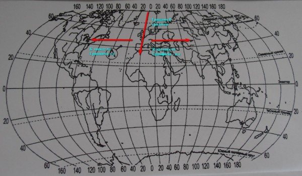
Measuring distances using a degree grid
The easiest way to determine geographic coordinates is to use a degree grid. It is plotted on any map or globe and allows you to determine the exact location of an object on the ground.
This data is used to determine distances on the map. Knowing the coordinates of certain objects on the map, you can calculate the approximate distance between them, since each degree is equal to 111.1 km. In this case, the direction of the objects’ location plays a role (Figure 2).
For example, if the distance is calculated from north to south, you must first determine the latitude of the northern and latitude of the southern point, and then multiply the resulting number by 111.1. This is enough, since the length of the meridians anywhere on the planet is approximately the same.
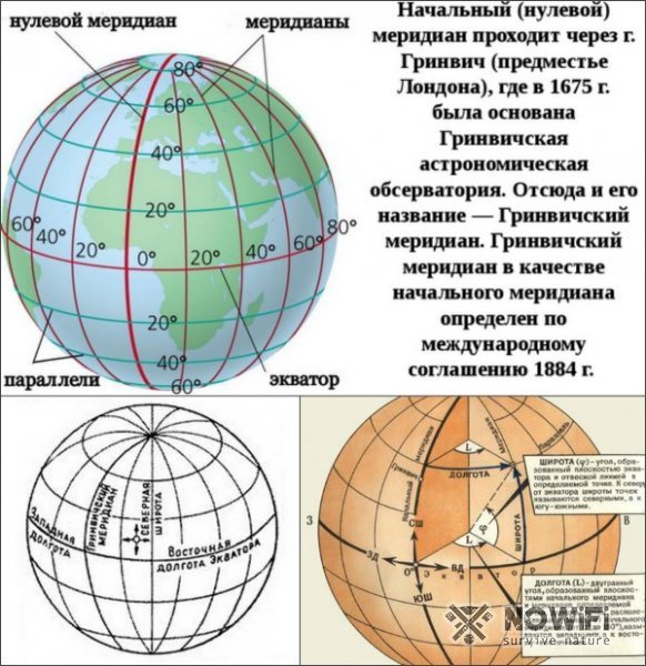
Figure 2. This is what the degree grid looks like
Calculations of distances from east to west are more complex. In the case of latitude, the length of the parallel decreases towards the poles.
For example, at the equator it is 111 km, at 20 degrees north or south latitude it is already 105 km, and at the poles it decreases to zero. That is why you need to know exactly the number of kilometers corresponding to one degree at each latitude.
At 40 degrees north latitude, one degree is equal to 85.4 km, and at 60 degrees it is already 55.8 km. Fortunately, this number is indicated on each parallel on globes and maps.
So, first you have to find out the longitude of the objects you are looking for, and then focus on their location. If both objects are located in the eastern hemisphere, it is enough to determine the difference between them in degrees.
If the longitude is different, the difference must be multiplied by the corresponding number of kilometers for each parallel.
What are geographic coordinates and how to work with them
Geographic coordinates help travelers find their way in oceans, seas, deserts and forests. Geographic coordinates are digital values that determine the position of a city, lake, building, any place on Earth, in the sky, and even on other planets. Coordinates are needed to find the desired object on a map or globe.
The Earth is divided into hemispheres: Northern and Southern (separated by the equator), as well as Eastern and Western (the border between them - also called the Prime Meridian - passes through Greenwich, an area in east London).
Geographic coordinates are written as numbers and include latitude, longitude, and absolute altitude. The numbers indicate how far a particular location is from the equator and the Greenwich meridian. Longitude and latitude are indicated by the first letter of the English word: N (North - Northern Hemisphere), S (South - Southern Hemisphere), E (East - Eastern Longitude), W (West - Western Longitude).
Latitude
Geographic latitude indicates the distance of the desired location from the equator (0°) in degrees. Everything north of the equator is designated north latitude, everything south of the equator is designated south latitude. Previously, to find the geographic latitude of a place, you had to know its parallel, which is written on a globe or map along the Greenwich meridian or near the frame. Now all coordinates can be found on the Internet. For example, Moscow is located above the equator, so it lies in the northern hemisphere. On the map we will see the capital between 40° and 60° north latitude, or more precisely, Moscow is located at 55° north. w.
Longitude
Geographic longitude is the distance from the Prime Meridian to the point on Earth you need. Indicated in degrees. The Greenwich, or Prime Meridian, passes through the observatory near London. On the map and globe, the Greenwich meridian is indicated by a thick line, and where it crosses the equator it is 0° (zero degrees). For example, St. Petersburg is located in the Eastern Hemisphere on the 30th meridian. This means that the longitude of the northern capital of Russia is 30° east longitude.
Degrees and minutes
The circumference of the Earth is divided into 360 degrees, one degree is divided into 60 minutes, and a minute is divided into 60 seconds. In the designation of coordinates, degrees are written first, then minutes, then seconds. Example: we found out that St. Petersburg is located on the meridian 30.19°
.
60 minutes × 0.19 = 11.4 minutes
Therefore, the coordinates of St. Petersburg are about 30 degrees 11 minutes east longitude.
Height
Absolute altitude is the height of the desired point above sea level, which is determined using a special device - a level, or a smartphone application. In Russia, the CIS countries and Ukraine, absolute altitude is measured by the level of the Baltic Sea
Maximum coordinate value
Since the Earth is shaped like a sphere, its total circumference in degrees will be 360. Accordingly, the longitude that divides the planet into two hemispheres (eastern and western) will have a maximum value of 180 degrees for each of them.
The maximum latitude value is 90 degrees, where 0 is the geographic coordinate of any point on the equator, and 90 is the value for each pole (north and south).
Detailed instructions for determining geographic coordinates are given in the video.
This is interesting: How to find a badger hole
Geographical location, determining the geographical location of your area
In this section, based on previously acquired geographical knowledge, we will pay more attention to practical exercises. The paragraph is devoted to the study of the geography of the native village, region, city.
To determine the geographical location of your village, you need to define the concept of “Geographical location”.
Geographic location - the position of a geographical object relative to the earth's surface, as well as in relation to other objects with which it interacts.
Therefore, in this paragraph we must determine the geographical location of our area.
To determine your geographic location, you need to answer the following questions:
- Write down the full name of your village (city, district, region) in your notebook.
- Determine the exact location of your district and region, write it down in your notebook.
- Determine which village or district your area is adjacent to, write it down in your notebook.
- After carefully studying the physical-geographical map, determine the geographic coordinates of your area and write it down in your notebook.
- After determining the geographical coordinates, write down in your notebook the length of the borders, neighboring villages, districts, cities, republics, water bodies and mountains.
Write down the distance of your area from the capital of the country and the advantages of communication with neighboring countries.
After completing the tasks, draw conclusions.
- Using textbook materials and additional literature, summarize the information you have collected about your area.
- Discuss the collected materials.
- Based on the work performed, draw a conclusion about the geographical location of your area.
Latitude and longitude - terms and definitions
The earth's sphere is divided by an imaginary horizontal line into two equal parts of the world - the northern and southern hemispheres - into positive and negative poles, respectively. This is how the definitions of northern and southern latitudes were introduced. Latitude is represented as circles parallel to the equator, called parallels. The equator itself, with a value of 0 degrees, acts as the starting point for measurements. The closer the parallel is to the upper or lower pole, the smaller its diameter and the higher or lower the angular degree. For example, the city of Moscow is located at 55 degrees north latitude, which determines the location of the capital as approximately equidistant from both the equator and the north pole.
Meridian is the name of longitude, represented as a vertical arc strictly perpendicular to the circles of parallel. The sphere is divided into 360 meridians. The reference point is the prime meridian (0 degrees), the arcs of which run vertically through the points of the north and south poles and extend in the east and west directions. This determines the angle of longitude from 0 to 180 degrees, calculated from the center to the extreme points to the east or south.
Unlike latitude, the reference point of which is the equatorial line, any meridian can be the zero meridian. But for convenience, namely the convenience of counting time, the Greenwich meridian was determined.
NATURE OF YOUR AREA:
RELIEF, CLIMATE, WATER, PLANTS AND ANIMAL WORLD, SOILS
- Features of the nature of your area
In this paragraph we will study the nature of our area.
In order to study the terrain, climate, waters, animals and plants of your place of residence, you must do the following work:
- Determine the topography of your area (mountain, flat, foothill, valley, etc.).
- What mountains are located here? What are their heights? What are their names? What legends do you know about the origin of the names of mountains, plains, and valleys?
- What mountains, plains, foothills, and depressions are visible from your school?
- What is the climate in your area?
- What changes occur in the weather throughout the year?
- At what time of year does there be more precipitation and when does it have less?
- What rivers flow through your area? What do you know about their names?
- How does a person use water in his life?
- Where are the sources of streams, rivers, lakes in your area? What tributaries flow in?
- What plants grow in floodplains of rivers and lakes?
- What summer pastures are available in your area and how are they used?
- What plants grow here (medicinal, fodder)? Write down their names.
- What species of animals live here? Are there any rare or endangered species among them?
- What animal species are protected? Write down the animals listed in the Red Book.
- What types of plants grow here? Name the protected plant species.
Practical work No. 16
Collecting materials on toponymy of the native land and preparing a message (this work is carried out in groups).
For example, according to the toponymy of the Burana Tower located in the Chui region (see page 188).
- Why does Burana Tower have this name?
Expert opinion
Makarov Igor Tarasovich
Hunter and fisherman with 20 years of experience. Wildlife lover
To answer this question, it is necessary to use additional literature and conduct inquiries among parents and elderly people who know the history of their region.
- Each group, having prepared their presentations, presents them for discussion.
- After viewing the presentations and discussing the information provided, we draw conclusions.
The ability to determine where latitude or longitude is on a map is important for a person. Especially when an accident occurs and you need to quickly make a decision and transfer coordinates to the police. She is recognized in different ways. They mean the angle that is the plumb line and the 0 parallel at a predetermined point. The value is only up to 90 degrees.
Don't forget that the equator divides the earth into the northern and southern hemispheres. Therefore, the latitude of points on earth that are higher than the longest parallel is northern, and if they are located lower, then southern.
How to find out the latitude of any object?
You can determine latitude and longitude on a map. Look at which parallel the object is indicated. If it is not indicated, then independently calculate the distance between neighboring lines. Then find the degree of parallel you are looking for.
At the equator, geographic latitude is 0°. Points that on the same parallel will have the same latitude. If you take a map, you will see it on the frames; if it is a globe, then where the parallels with the 0° and 180° meridians intersect. Geographic latitudes range from 0° and only up to 90° (at the poles).
How to set geographic coordinates on a map?
To calculate the coordinates of an object on the map, you must first determine in which hemisphere it is located. Next, you need to find out between which parallels the desired point is located and set the exact number of degrees - usually they are written on the sides of the geographical map. After this, you can proceed to determining longitude, first establishing in which hemisphere the object is located relative to Greenwich.

Determining degrees of longitude is similar to latitude. If you need to find out the location of a point in three-dimensional space, its height relative to sea level is additionally used.