Details Author: Sergey Fedoseev If you are lost in the forest and have no idea in which direction to move, then the first thing you need to do is try to determine at least the cardinal directions. Yes, you should have a compass with you, yes, there are navigators, phones and other devices. But it may turn out that you have none of this. That's all. In this situation, you can determine where north and south are by looking at the quarter posts, which are found in almost all forests.
First, a little theory.
What is a quarter pillar?
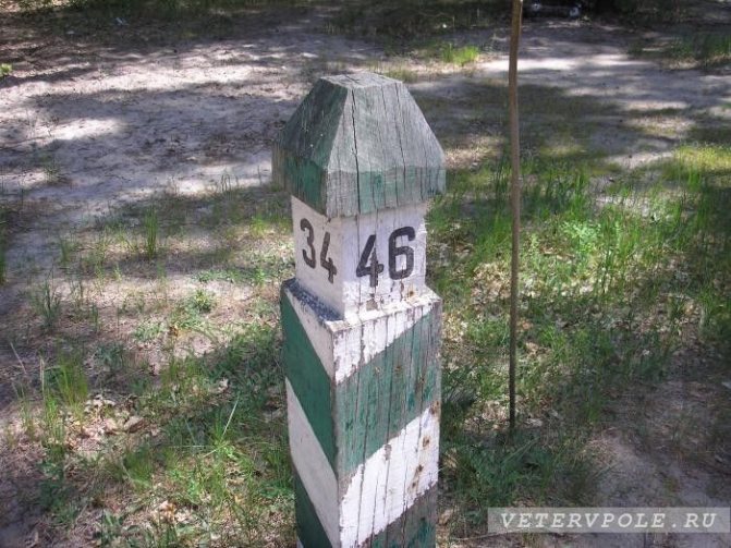
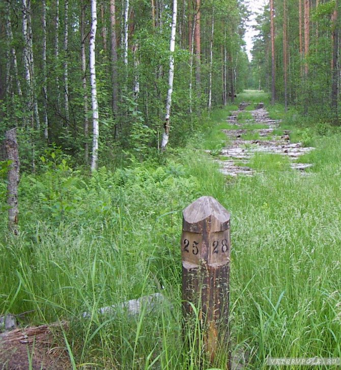
A quarter post is a wooden post about 20 cm in diameter. Its upper part is hewn in the form of a tetrahedral pyramid, and on the sides there are flat cuts on which the numbers of forest blocks are painted. Such poles are installed at the intersection of forest clearings and serve to mark forestry.
Orientation according to tourist markings
Tourist marking is a system of special symbols that are applied to local objects to mark tourist routes.
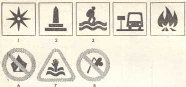
Rice. 33. Some advisory, prohibitory and restrictive signs of tourist markings: 1 - attraction; 2 - monument or memorial place; 3 - ford; 4 — bus stop; 5 - place for making a fire; 6 - halting is prohibited; 7 - place dangerous for swimming; 8 - no touching allowed
Marking includes various types of marks, directional arrows, pointers and other signs, which in their symbols, shape, color and alphanumeric code carry the information necessary for tourists and help navigate the area.
The main marking element - the route mark - has the shape of a rectangle (the main format is 180-240 mm), on a white field of which there is a colored stripe or a square placed on the corner. A stamp with a red stripe indicates a multi-day category route, a stamp with a blue stripe indicates a “USSR Tourist” badge, a stamp with a green stripe indicates a 3-4-day route, and a yellow stripe indicates a 1-2-day route (with overnight stays). Stamps with colored squares indicate different routes for hiking without overnight stays.
Rice. 34. Simplified tourist markings: 1 - observation point; 2 - monument; 3 - drinking water; 4 - shelter, place for bivouac; 5 - danger; 6 - end of the road
Guided by the stamps, tourists can follow the route without a map, compass or description: directional, warning, prescriptive and prohibitory signs will tell you where there are objects for inspection, bivouac areas, shelters, protected natural attractions, swimming places, what is the distance to this or that point, what types of tourist activities are allowed, what dangers are expected ahead, etc. Some of these common signs are shown in Fig. 33. Since full marking is carried out, as a rule, only on planned routes, simplified marking signs are also used for orientation on amateur trips of categories I-III of complexity (Fig. 34).
How to navigate by quarter posts?
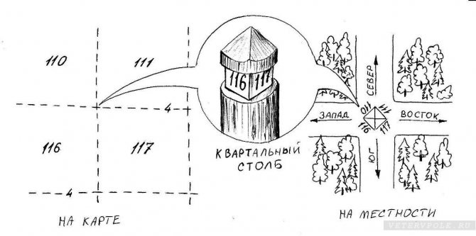
Typically, clearings in the forest are located in the north-south and west-east directions. You need to walk along the clearing until it intersects with another clearing and find the quarter post. The numbers on the quarter pillar face the corresponding quarters. And the edges between these hedges are directed along the clearings separating the forest blocks. If the clearing runs in the north-south direction, then the edge between the two smaller numbers will point north , and the edge between the two larger numbers will point south. If you look north along the clearing, you will see east on your right and west on your left. This way you can roughly determine the direction.
Attention! Forest clearings and neighborhoods do not always correspond to the cardinal directions.
There are clearings with directions northwest to southeast and northeast to southwest. And sometimes the direction of the clearing is simply deviated by some angle from the direction to the north. The quarter post will be oriented according to the clearing.
Orientation in the forest: how not to get lost in three pines.
You can get lost even in a well-known forest, let alone in an unfamiliar area. Most often, people, carried away by chasing an animal or picking berries and mushrooms, at one point cease to understand where they are. What to do in such a situation? First of all, stop and calm down.
The best and surest option is to have a compass with you (or even better, along with a map of the area), and at the beginning of your movement, choose in the direction of which side of the world you will go. In this case, it will not be difficult to return in the opposite direction.
When moving, try to remember particularly noteworthy features of the area: paths, anthills, ravines, fallen trees - later this can serve as a guide for you when returning. As soon as you realize that something has gone wrong, it is better to sit down and put your thoughts in order. Try to remember your path, listen. If you are close to populated areas, then listen - the sounds are clearly audible on rough terrain, and, say, you will hear a dog barking from the nearest settlement at a distance of 2-3 km, a working tractor - from 3-4 km, the noise of a railway - from 10 km.
The sun is your friend when orienteering.
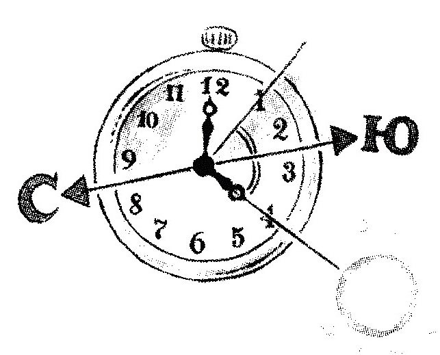
Pay attention to which side the sun was on. With the help of the sun and a clock, you can also determine the direction of light. In order to do this, it is enough to point the hour hand towards the sun. The north-south line will be the bisector of the angle between the hour hand pointing towards the sun and the 1 o'clock line. In the first half of the day, the south will be to the right of the sun, and in the afternoon, on the contrary, to the left.
Nature determined the cardinal directions before the advent of the compass.
If the sun is not visible (fog, clouds), then nature will help you navigate the forest.
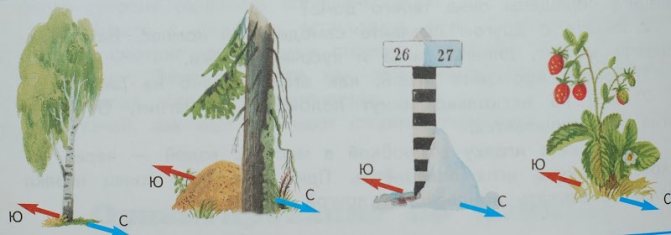
Pay attention to the surrounding vegetation and trees.
Pointing south is:
- in the northern hemisphere, more light and heat comes from the south, so the crown of trees is lush and dense, and the branches are longer and more elongated on the south side. This is especially noticeable on isolated trees;
- the bark of birch and aspen from the south is cleaner and lighter;
- streaks of pine resin also indicate a southerly direction;
- the southern slope of the hill will be more grassy and green in early summer, and more scorched and dry in the second half of summer;
- pay attention to the anthill: under a stone or stump it will be located on the south side, the slope of a free-standing anthill will also be flatter on the south side.
North is indicated by:
- The bark of birch and aspen on the north side will be rougher and darker;
- After rain and in wet weather, the trunks of coniferous trees turn black on the north side, which is especially noticeable in pine trees. This is explained by the fact that a thin secondary crust is developed on the pine bark, which forms earlier on the shady side of the trunk and extends higher than on the southern side. When it rains, this crust darkens and swells, and since the sun's rays almost never reach it, it takes longer to dry;
- Dew lasts longer on the northern slope of the hill;
- Mosses and lichens - shade-loving and moisture-loving plants - grow thicker on the north side of trees and stones. The moss on the north side is wetter.
This does not apply to dense forests and thickets - the forest hinterland lives by its own laws. It is better to use these signs at the forest edge.
I sit high and look far away.
Try to climb a tree or other hill to look around and possibly notice global landmarks. Having seen a long gap in the forest crowns, you can find a river, a clearing, a road. Decreased relief and ravines can lead to streams, which in turn lead to rivers.
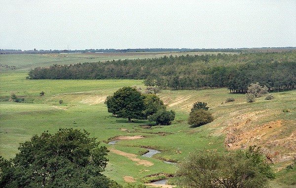
The greatest interest and value for determining the sides of the horizon are clearings, edges, clearings with trees, plants and objects standing separately on them, on which the influence of solar heat is much more pronounced. Information obtained on the basis of such signs, rechecked several times in different ways, can give a fairly clear idea of the location of the sides of the horizon.
Orientation in the forest along forest clearings.
If you are not wandering in the remote taiga, you will most likely stumble upon quarter posts.
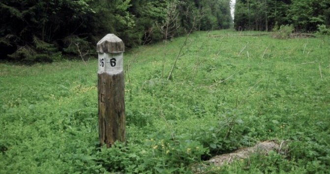
As a rule, clearings are cut in the north-south and east-west directions. The forest is thus divided into quarters, which are numbered from west to east and from north to south: the first number is placed in the northwest corner, and the last in the southeast. At the intersection of the clearings, quarter pillars are installed, the upper part of which is hewn in the form of edges. On each edge the number of the quarter opposite it is signed. The edge between the two smallest numbers indicates the direction north. It is necessary, however, to take into account that sometimes, for economic reasons, clearings are cut without any correlation with the sides of the horizon...
Never try to determine the cardinal directions only by one criterion. Only a set of signs repeated more than once can guarantee the determination of cardinal directions.
There is always a danger of starting to walk in circles - this is how our body works, deflecting us when moving in one direction. To move in a straight line, select a landmark directly in front of you, when you reach it, select the next landmark, and so on. Another trick is to tie a long rope or cable to yourself. Having walked straight a distance approximately equal to the length of the rope, look back: if the rope is bent, then you need to adjust the course.
As soon as doubts arise about the correctness of the chosen direction of movement, you need to immediately stop and try to restore your orientation. If this fails, you need to retrace your steps. In this case, there is no need to cut off loops and corners - an attempt to save energy and time in this way usually does not lead to anything good and is fraught with the loss of the last opportunity to determine your location.
The forest does not tolerate mistakes, haste, self-confidence and risk. If you calm down and use your head, the forest will help you find your way. But if you approach your orientation in a state of panic, it may turn out that the wolves will not need to go to the outskirts in search of food.
Take care of yourself, navigate the forest wisely.
How are forest areas marked on the map?
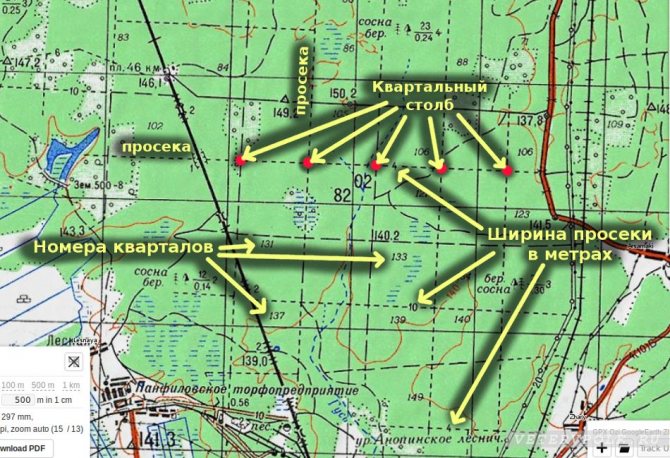
On the map, forest areas are usually indicated by a dotted line.
Block numbers are located in the center of the block and are always written in italic font. The number on the dotted line demarcating the forest blocks indicates the width of the clearing in meters.
To be sure of the direction of the clearings between forest blocks and not to deviate from the correct direction when navigating along the block posts, you need to study a map of the area in advance, and it is better to have such a map with designated blocks with you.
If your map is old, the block numbers may differ from the real ones, but the direction of the clearings and additional landmarks (stream, lake, power lines, road) will remain in place and with their help, even with an old map, you can quite accurately determine your location.
orientation
- < Back
- Forward >