Despite advanced methods that have given people ease and speed in navigation, each of us can easily find ourselves in a position where it is vitally important to find the right path in unfamiliar terrain. Learning to determine the direction at the right moments, where is north, and where is west, south and east, is not difficult if you know the principles of orientation.
If a person is lost or has mixed up the path, then a mobile navigator is the first reliable and convenient assistant, which will show not only north and south, east and west, but will also draw a given path.
What if there is no network or phone with such an application? Then the old, proven companions of any traveler come to the rescue - a compass and a map, which will help you navigate and not stray from the original path.
But it happens that you don’t even have a map and compass with you, and you don’t know where to go. Then the location of the cardinal directions - north, south, east and west - is determined by indirect landmarks.
North, south, west, east: location
The locations of north, east, south and west are called cardinal directions or cardinal points, and are usually designated by the letters, N, E, S, W. East and respectively west are located at right angles to north and south, and east is on a clockwise rotation vector arrow from the north and west directly opposite the east. The points between the directions form compass points. Intermediate (intercardinal or ordinal) directions are northeast, southeast, southwest and northwest. The intermediate direction of each set between the cardinal and cardinal directions is called the secondary - intercardinal direction, which is denoted by:
- NNE.
- ENE.
- ESE, etc.
How to determine without a compass where is north and where is south

Thanks to advanced technologies, it is now difficult to get lost in unfamiliar areas. But situations are quite likely when a person finds himself without a connection or a compass in a forest or in the mountains, and perhaps in an unfamiliar city. Then the problem of how to determine where north is without a compass becomes vitally important.
In such a situation, simple principles of orientation based on indirect signs that were used in ancient times can help out. They require a little theoretical knowledge of biology and astronomy and practical skills.
Sun
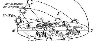
The position of the Sun in the sky can be used for orientation if the general time of day is known. In the morning the sun rises approximately in the east. In the evening the sun sets approximately in the west. At midday, it is in the south for Northern Hemisphere viewers who live north of the Tropic of Cancer, and in the north for Southern Hemisphere viewers who live south of the Tropic of Capricorn. This method does not work very well when the observer is closer to the equator (i.e. Between the Tropic of Cancer and the Tropic of Capricorn).
Due to the axial tilt of the Earth, regardless of the viewer's location, there are only two days each year when the sun rises due east. These are the days of the equinox. On all other days, depending on the time of year, the sun rises either north or south of true east and falls north or south of true west.
Determining cardinal directions using a watch
This method of orientation is based on the exclusive property of the Sun - to indicate the direction of the South at 13 o'clock. At other times of daylight, you can set the direction of the cardinal directions using a wristwatch with an arrow dial.
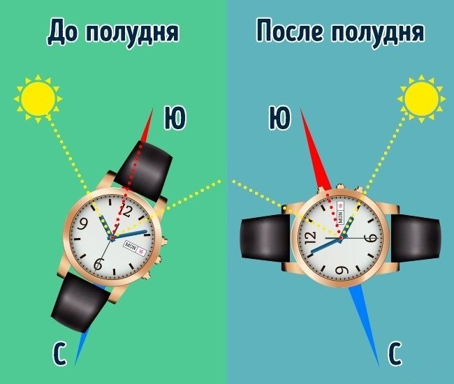
To do this you need:
- Place the watch in your hand in a horizontal position.
- Turn them so that the hand showing the clock points to the Sun.
- Mentally draw the bisector of the angle formed between the hour hand and the direction in which the number 1 is located. It will indicate the southern direction.
- The correctness of this determination method depends on the position of the Sun relative to the horizon. The higher it is, the greater the probability of error (it can reach 10°). In southern latitudes, due to the high position of the Sun, this method of orientation is not suitable.
Astronomy
Astronomy provides a method for finding direction at night. All stars lie on an imaginary celestial sphere . Due to the rotation of the Earth, the celestial sphere rotates around an axis passing through the Earth. This axis intersects the celestial sphere at the north and south poles of the celestial zone, which, according to the observer, lie directly above the north and south, respectively, on the horizon.
In either hemisphere, observations of the night sky show that visible stars move in circular paths caused by the Earth's rotation. This is best seen in long exposure photography. The resulting photograph shows many concentric arcs (parts of perfect circles) from which the exact center can be easily obtained. This center corresponds to the celestial pole, which lies directly above the position of the true pole on the horizon.
The north celestial pole is currently (but not always) within 1 degree of the star called Polaris. The exact position of the pole changes over thousands of years due to the precession of the equinoxes. The North Star is visible only on cloudless nights for residents of the Northern Hemisphere.
While observers in the Northern Hemisphere can use Polaris to locate the North Celestial Pole, the southern star of the constellation Octantus is barely visible to use for navigation. For this reason, the preferred alternative is to use the Southern Cross constellation.
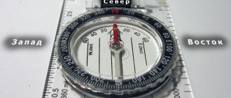
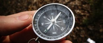
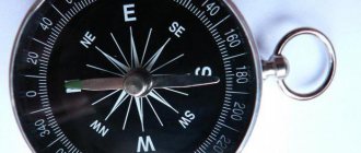
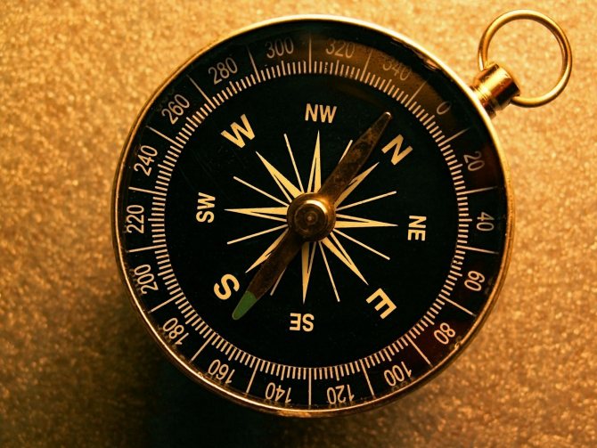
Determining the location of the cardinal directions using a magnetic compass
All magnetic compasses, despite the difference in design, work on the same principle - they turn with a magnetic needle along the line of magnetic poles present on the Earth, indicating its direction.
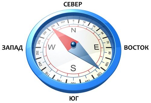
- The long tip of the arrow will face north, the short tip will face south.
- Usually the arrow that shows the north direction is painted blue, or simply marked as the main one. The arrow pointing south is painted red.
There are 4 letter symbols on the dial corresponding to the cardinal directions:
Cardinal directions on the compass
- North is usually designated by the letter N, corresponding to the international name North, that is, north, but the Russian S can also appear.
- South is similarly designated by the letter S, which corresponds to the name South, that is, south, but the Russian Yu is also found.
- Vostok is marked with the letter E, meaning East, that is, ost, but sometimes the Russian V is placed.
- West will correspond to the letter W, indicating the name West, that is, west, but the Russian Z can also stand.
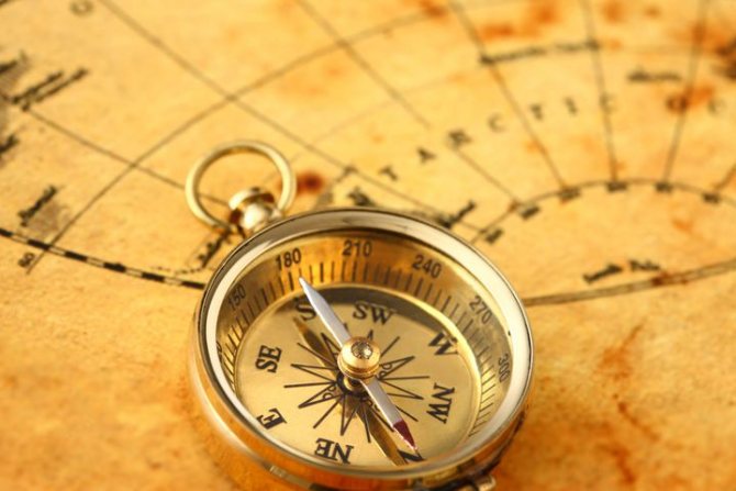
Using a compass to determine north, south, west, east and their locations is not at all difficult if you understand simple rules.
- The compass must be positioned exactly horizontally, otherwise the error may be critical.
- Carefully turn the device until the swinging arrow with its long end stops at the N mark, and the short end at S.
- The line along the arrows will indicate the north and south directions.
- If you turn your gaze to where the north arrow is pointing, you will be looking north, the south will be behind you, the east will be on your right hand, and the west will be on your left hand.
- Having decided on the orientation of where north, south, east and west are in relation to you, you can now move on to the question of where exactly you need to move.
- Some compasses have an additional fixed arrow that can be used to set the path you need. It needs to be adjusted in accordance with the direction of your route.
- There are compasses with a built-in compass, which can be used to easily calculate azimuth.
- If the compass is simple, it’s not scary, you just need to select the required direction of the route, correlate it with the compass and find a suitable large object located in the distance as a landmark.
- It could be a tall building, a large tree, a mountain top, a temple dome, a tower, a chimney, etc.
- Feel free to walk to the landmark, and when you reach it, check the movement again with the compass indicators.
Remember! The position of the hands is greatly influenced by other magnetized objects and devices, high-voltage power lines, and the abundance of metal around, so severe distortion is possible!
Gyro-compass
At the very end of the 19th century, in response to the development of battleships with large transverse guns that acted on magnetic compasses, and perhaps to avoid the need to wait for good weather at night. In order to accurately check its alignment with true north, a gyrocompass was developed . Because it finds true poles rather than magnetic ones, it is immune to interference from magnetic fields.
Its main drawback is that it relies on technology that many people may find too expensive to be worthwhile outside the context of a large commercial or military operation.
Satellite navigation
At the end of the 20th century, the advent of satellite global positioning systems provided another means of accurately determining true north. Government agencies in charge of satellites constantly monitor and adjust them to maintain their precise alignment with the Earth.
Unlike a gyrocompass, which is most accurate when stationary, a GPS receiver, if it has only one antenna, must move, usually at speeds greater than 0.2 km/h, to correctly display compass directions. On ships and aircraft, receivers are often equipped with two or more antennas separately attached to the vehicle.
Use of cardinal points for making maps
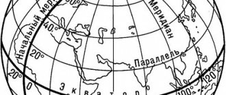
Thus, with the cardinal points precisely defined, by convention cartographers draw standard maps with north (N) at the top and east (E) at the right . In turn, maps provide a systematic means of recording places, and cardinal directions provide the basis for a structure for locating those places.
In the real world there are six cardinal directions not related to geography, which are north, south, east, west, up and down. In this context, up and down refer to height, or perhaps depth (if water is involved). A topographic map is a special case of cartography in which elevation is indicated on the map, usually through contour lines.
How to calculate cardinal directions without a compass, smartphone and map?
Now that we all have GPS and Google Maps with Yandex.Maps on our phones, which are always with us and ready to serve us at any moment, we have already forgotten many useful techniques that we were taught back in school during geography lessons and which they helped us navigate space so well in any conditions, without maps, without compasses and, of course, without these same smartphones.
And okay, we, those who managed to enjoy a non-synthetic life without the influence of smart phones, all kinds of electronic assistants and all kinds of electronic devices, but the new generation born in the early 2000s and later, unfortunately, did not come into contact with those rules of the game , which were used before the Apple electronic revolution. But even though they were more complex, they could perfectly develop logic and ingenuity in a person, teach intelligence and help in difficult times. Because they were really useful...
But sometimes without knowledge and without your favorite smartphone you simply cannot survive! For example, you are walking in the forest, winter. At some point, you lose sight of the trodden path and realize that you are lost. It doesn’t matter, you reason, and, taking your phone out of your pocket, you try to enter the “maps” application. And suddenly... you realize that your phone is not working. From the word “in general”! The battery is low. What will you do to get your bearings, to find where north, south, west and east are?
Okay, let's not even take such an extreme example, let's say you're just curious about which cardinal directions are located? You cannot pick up a smartphone. Maps and compasses too. What will you do? We will tell you how to act correctly in such a situation.
Here are some strategies that will point you in the right direction, and you will find it solely through your knowledge and not through assistive devices.
Origin of ancient names
During the invasion of the Huns, names from Germanic languages for cardinal directions entered the Romance languages, where they replaced Latin names. Some northerners used Germanic names for intermediate destinations.
In many regions of the world, prevailing winds change direction seasonally, and so many cultures associate specific winds with cardinal and intercardinal directions. For example, classical Greek culture characterized these winds as Anemoi.
In post-medieval Europe, cardinal and intercardinal movements were given names. These often corresponded to the directional winds of the Mediterranean (for example, the southeast was associated with the Sirocco, a wind from the Sahara).
The relative position of the main and intermediate sides of the horizon
There are main directions - north, south, west, east - which are supplemented by intermediate ones. This division is very convenient; it allows you to more accurately determine the location on the ground, find objects on maps and topographic plans. For example, northeast is the side of the horizon located between the direction of north and east. On maps, plans, dials, in textbooks, reference books, designations are introduced using the first letter of the Russian or Latin name. There is a more detailed division of the sides of the horizon. Thus, between the directions from and north to east there are north-northeast (neast) and east-northeast (east).