Every year, many thousands of earthquakes of varying intensity are recorded on the planet. Most of them have a weak manifestation and cannot be detected without special devices. But several times a year there are serious tremors, when the shaking of the earth's crust is intense enough to destroy ground objects. Since the most powerful tremors occur within the oceans, in the absence of a tsunami the public is unaware of their existence. But when the fluctuations cover land, the phenomenon becomes catastrophic, accompanied by enormous destruction and loss of life.
What is an earthquake
These are vibrations of the earth's surface that can be caused by various reasons. Compression and tension waves spread from the source of the earthquake, causing movement and destruction of the earth's crust.

The epicenter is the projection of the source onto the surface of the earth. The hypocenter is the central point, the focus of an earthquake in the earth's crust, from which earth tremors radiate.
Earthquake statistics
As we already know, earthquakes with a magnitude of 7-12 are considered dangerous. They are the ones that can lead to destruction and changes in the planet’s topography. And although it is impossible to say exactly how many such phenomena occur annually, it is possible to calculate the approximate number of the most powerful of them. Two centuries ago, for example, there were about 40 earthquakes per year with a magnitude of 7 or higher. Now their number has increased tenfold. 400 strong earthquakes per year have already become the norm for the Earth. The trend is impressive, isn't it? And what will happen next?
Causes of earthquakes
The main reason earthquakes occur is the shifting of the tectonic plates that make up the earth's surface.
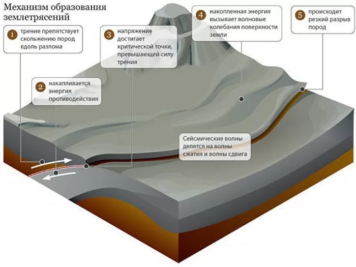
The solid crust of the earth is only a thin layer on the surface of hot plastic magma, whose properties resemble a viscous liquid. These are molten rocks under enormous pressure.
Therefore, continental platforms can be compared to islands floating on an ocean of liquid magma. In places where they touch and rub against each other, areas with the highest seismic activity arise. As a result of these processes, stresses arise in rocks lying closer to the surface, which are relieved by earthquakes.
The Moon also has a great influence on seismic processes. Our satellite causes ebbs and flows not only in the oceans, but also in the bowels of the planet, deforming them. These strains can also accumulate and eventually cause earthquakes.
Volcanic
The most prominent representative of this group is the Krakatoa volcano, the eruption of which at the end of the 19th century destroyed part of the island where it was located, and subsequent earthquakes split the rest. All the debris sank into the ocean, and waves splashed on the site of the island. Residents of neighboring islands died in the tsunami waves on neighboring islands.
In the 20th century, a new cone began to grow on the site of the old volcano; it was called Anak-Krakatoa (“child of Krakatoa”). The "Child" continuously grows and erupts, causing earthquakes.
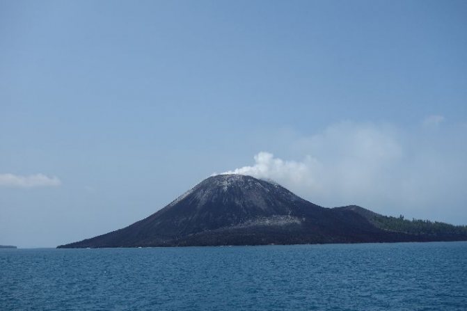
Rice. 2. Anak-Krakatau volcano.
How are seismic waves measured?
The magnitude of seismic waves is determined on the Richter scale.
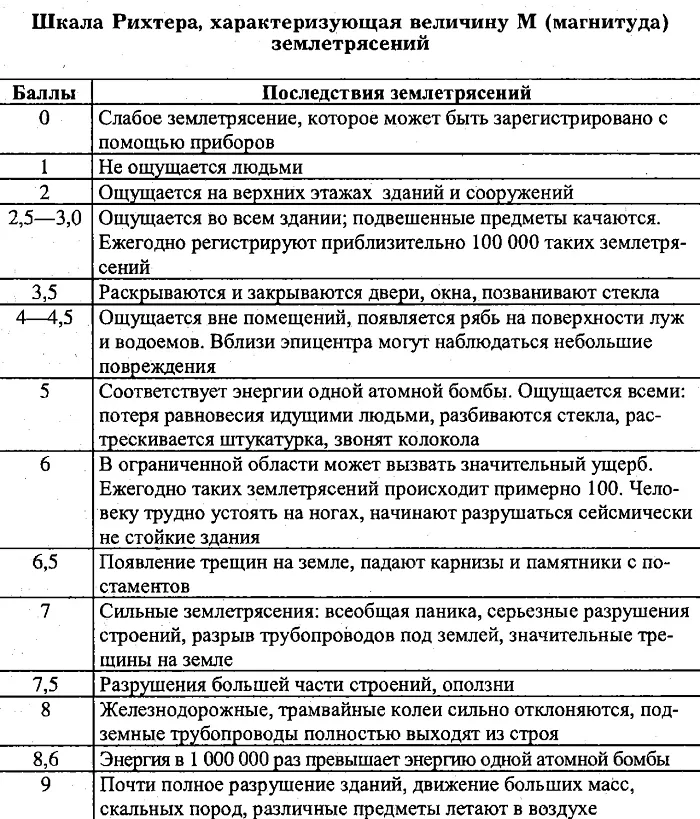
Magnitude is the logarithm of the ratio of the wave amplitude of a particular earthquake to the accepted standard one. This value shows the displacement of parts of the soil relative to each other. Both longitudinal and vertical waves are taken into account.
The Richter scale has no upper limit. The values may be fractional and may not always coincide with the 12-point scale.
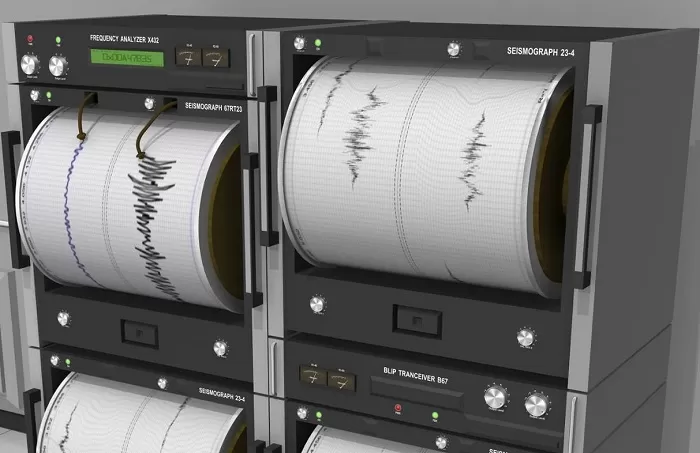
Measurements are made using a seismograph, a special device that records waves in the form of graphic curves.
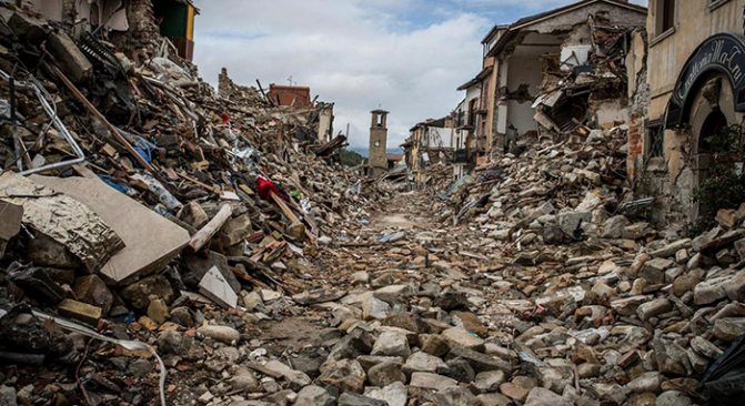
Consequences of the disaster
If you watch an earthquake on a TV screen, this spectacle is very unusual and exciting. But being a direct participant is very dangerous, because this phenomenon is so destructive that it leaves behind complete devastation, the consequences are very significant.
- Many structures are destroyed by soil vibrations . And if this happens in the depths of the sea, a giant wave arises - a tsunami , which kills ships that find themselves in the danger zone.
- Houses built with clay . This happened in the 70s of the last century in Guatemala. It is in the region of this country that there is a border between two plates, which are gradually but inevitably shifting relative to each other. It is because of this that soil vibrations occur, and very significant ones at that. In 1976, a shift of 1.3 m . And although this lasted no more than a minute, an underground collision was felt over an area of 100,000 km2 , landslides appeared, of which there were more than a thousand, clay structures could not withstand the load and collapsed, modern buildings, communications, and railway tracks were destroyed. But these were not the most serious consequences of the natural disaster. Almost 23 thousand people were killed almost 77 thousand were injured . Neighboring countries were also affected.
- 230,000 inhabitants could not escape from tremors , and changes also occurred in the area, as a result of which a new lake emerged. In China, in 1290, 100,000 people , and in Japan in 1703, a tsunami killed more than 100,000 .
- The earthquake in Chile is considered the most dangerous. It happened in 1960, and although scientists determined that a disaster was approaching, and rescue services helped residents evacuate, more than 100,000 people .
- In Mongolia in 1957, an earthquake completely changed the topography , high mountains collapsed, and therefore the mountain ranges changed significantly.
- The movement of plates in the Indian Ocean provoked the occurrence of many tremors, which were noted at a distance of more than 1,500 km, and huge waves that reached the shores. Tens of thousands of people died from them, entire villages located on the coast disappeared.
Earthquake scale
The intensity of an earthquake is measured by its consequences and interviews with eyewitnesses. In Japan, a 9-point classification is used, but in the world a 12-point scale is more often used (in America - the Mercalli scale, in Russia - MSK-64
, in Europe - EMS).
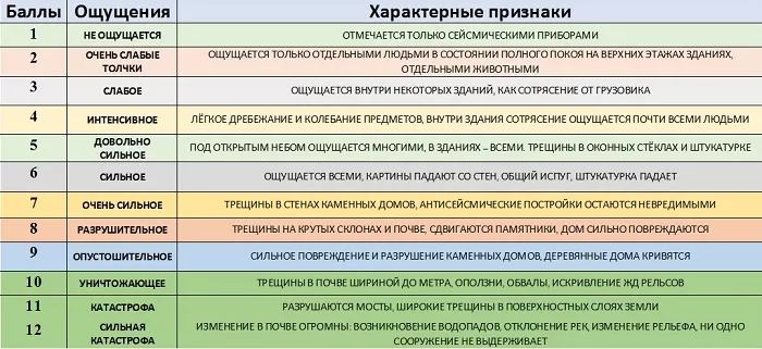
List by points:
- 1 point – people practically don’t notice;
- 2 points – slight vibrations may be felt;
- 3 points – suspended objects sway, round things sway. Considered weak;
- 4 points – moderate. Doors slam, loose things fall, but in an open space in a field a person may not notice it;
- 5 points - everyone feels such an earthquake: dishes break, cabinets fall, plaster cracks, pillars and trees bend on the street;
- 6 points – strong, brick houses are cracking, soil disturbances interfere with walking, trees are shaking;
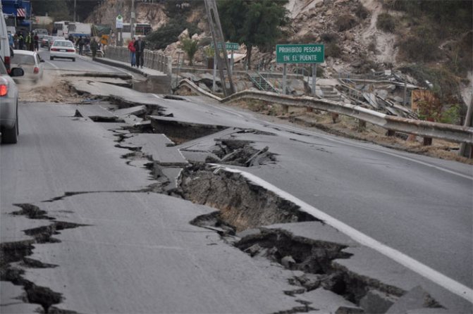
- 7 points – cracks appear in the ground, chimneys collapse, landslides appear on the slopes;
- 8 points – some standard buildings are destroyed, factory chimneys fall, the water level in reservoirs changes;
- 9 points – underground communications are torn, many houses are completely destroyed;
- 10-12 points - buildings are destroyed, the terrain changes.
Strength of earthquakes
Due to the fact that during earthquakes its energy is produced in many different forms (magnetic, electrical, mechanical), it is impossible to measure the force of its action with absolute accuracy. The greatest part of the destructive power of this natural phenomenon occurs at the epicenter of its occurrence, and the rest of the energy turns into waves, the strength of which decreases with increasing distance.
Strength of earthquakes
The strength of an earthquake is usually determined by such concepts as intensity, magnitude and energy class. The most accurate measurement of the amplitude of an earthquake is considered, that is, the magnitude of the vibrations that arise directly at the very epicenter of the disaster, and the concept of intensity or intensity, measured in points, is more often used in everyday life, since it is this that allows us to characterize the strength of the earthquake on the surface of the earth’s crust. The stronger the earthquake and the closer its epicenter, the greater the intensity. Let's consider the impact of this natural disaster depending on the number of points of its intensity:
- From 1 to 2 points – insignificant shock force, which can only be determined with the help of special instruments. Earthquakes of magnitude 2 can also sometimes be detected by a person if at that moment he is motionless.
- From 3 to 4 points - tremors are felt more strongly in high-rise buildings, chandeliers may sway, objects may be slightly mixed, and a feeling of slight dizziness may occur.
- From 5 to 7 points - the tremors begin to be felt quite strongly on the ground, minor destruction of buildings is possible, for example, cracks begin to appear on the walls, windows break, and plaster crumbles.
- 8 points - an earthquake causes deep cracks in houses, the ground and even slopes.
- 9 points - the tremors become so strong that they can destroy the walls of houses and even some underground communication structures.
- From 10 to 11 points - an earthquake of such strength causes severe destruction of many buildings, bridges, collapses, and landslides.
- 12 points - the force of destruction of such a force of shocks can significantly change the surface of the earth's crust, practically crumble buildings and even change the movement of water in rivers.
The strength of an earthquake largely depends on how close to the Earth's surface internal changes and movements of the earth's crust occurred. The closer the source, the greater the destructive power of a natural disaster.
What happens during a major earthquake?
Waves are visible on the surface of the earth, new geological formations appear, reservoirs, and rivers change their course. People and animals die.
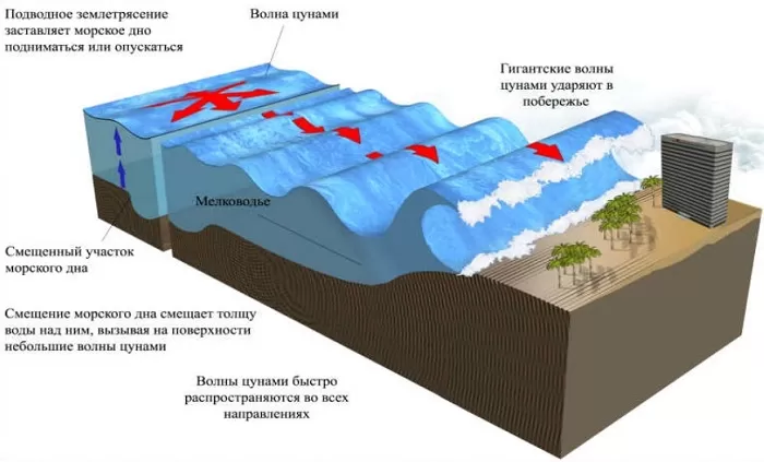
If an earthquake occurs in a coastal area, a tsunami often occurs. A general decrease or increase in ground level may occur.
Famous facts from history:
- The strongest earthquake recorded by seismologists occurred in Chile in 1960; it measured 9.5 on the Richter scale. After this there was a tsunami 10 meters high. The waves crossed the Pacific Ocean and reached the shores of Japan. 6,000 people died. Two million people were left homeless.
- The greatest number of deaths was caused by the Chinese earthquake in 1920. Huge cracks appeared that swallowed up entire villages. 230,000 human casualties.
Unfortunately, many more such natural disasters have happened.
1908 Messina earthquake
The strongest earthquake in the history of Europe occurred on December 28, 1908 at 5:20 in the Strait of Messina between the Apennines and Sicily. Several aftershocks with a magnitude of 7.5 caused massive destruction in more than 20 communities in the coastal strip of Sicily. After this, three tsunami waves hit the coast, completing the deed with an earthquake.
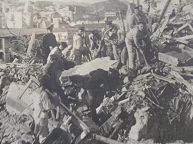
Russian sailors from the battleship "Slava" help carry out rescue work after the earthquake in Messina (Italy). December 28, 1908
The number of deaths during this tragedy exceeded 123 thousand people. According to some researchers, the number of victims was 200 thousand people. The city of Messina was the hardest hit, where about 60 thousand inhabitants died out of a population of 150 thousand people.
Consequences of earthquakes
After a strong earthquake, changes occur in the landscape: landslides appear, groundwater levels change. In the urban environment, due to the destruction of electrical networks and gas pipelines, fires begin.
]
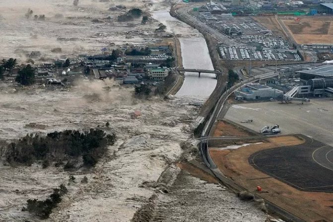
All communications are disrupted. As a result, evacuation of the population, hunger, and looting. A tsunami rises in coastal areas, causing even greater damage to the economy and people's lives.
As an example, in Japan, a nuclear power plant was destroyed in the city of Fukushima. There was radioactive contamination of the area. Some of the radiation entered the Pacific Ocean. Such disasters reverberate throughout the world.
Geographical distribution of earthquakes.
Most earthquakes are concentrated in two long, narrow zones. One of them frames the Pacific Ocean, and the second stretches from the Azores east to Southeast Asia.
The Pacific seismic zone runs along the west coast of South America. In Central America it splits into two branches, one following the island arc of the West Indies, and the other continuing north, expanding within the United States, to the western ranges of the Rocky Mountains. Further, this zone passes through the Aleutian Islands to Kamchatka and then through the Japanese Islands, the Philippines, New Guinea and the islands of the southwestern Pacific Ocean to New Zealand and Antarctica.
The second zone from the Azores extends east through the Alps and Turkey. In southern Asia, it expands and then narrows and changes direction to the meridional, passes through the territory of Myanmar, the islands of Sumatra and Java and connects with the circum-Pacific zone in the region of New Guinea.
There is also a smaller zone in the central part of the Atlantic Ocean, following along the Mid-Atlantic Ridge.
There are a number of areas where earthquakes occur quite frequently. These include East Africa, the Indian Ocean and in North America the valley of the St. River. Lawrence and northeastern USA.
Sometimes strong earthquakes occur in areas that are considered inactive, such as in Charleston, South Carolina in 1886.
Compared to shallow-focus earthquakes, deep-focus earthquakes have a more limited distribution. They have not been recorded within the Pacific zone from southern Mexico to the Aleutian Islands, and in the Mediterranean zone - west of the Carpathians. Deep-focus earthquakes are characteristic of the western edge of the Pacific Ocean, Southeast Asia and the western coast of South America. The zone with deep-focus sources is usually located along the zone of shallow-focus earthquakes on the continental side.
Other types of earthquakes
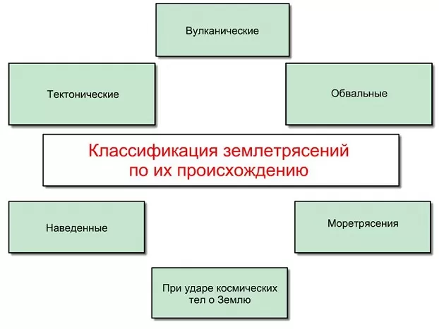
There are several varieties:
- Man-made tremors are caused by underground nuclear tests, mining operations using explosive technologies, the exploitation of oil and gas fields, and collapses during quarrying.
- Volcanic earthquakes often precede a volcanic eruption. They are not strong, but they are long lasting.
- Landslide tremors occur when large voids in the bowels of the earth collapse under pressure from the overlying soil.
- Earthquakes of artificial nature. Unlike natural phenomena, this class of tremors is created by people on purpose. This may be carried out for research purposes or to extinguish fires in gas fields.
Registration of earthquakes.
The device that records seismic vibrations is called a seismograph, and the recording itself is called a seismogram. A seismograph consists of a pendulum suspended inside a housing by a spring and a recording device.
One of the first recording devices was a rotating drum with paper tape. As the drum rotates, it gradually moves to one side, so that the zero line of the recording on the paper looks like a spiral. Every minute, vertical lines are drawn on the graph - time stamps; For this purpose, very precise watches are used, which are periodically checked against the exact time standard. To study nearby earthquakes, marking accuracy is required—to the nearest second or less.
In many seismographs, induction devices are used to convert a mechanical signal into an electrical one, in which, when the inert mass of the pendulum moves relative to the body, the magnitude of the magnetic flux passing through the turns of the induction coil changes. The resulting weak electric current drives a galvanometer connected to a mirror, which casts a beam of light onto the photosensitive paper of the recording device. In modern seismographs, vibrations are recorded digitally using computers.
Is it possible to prevent the death of people?
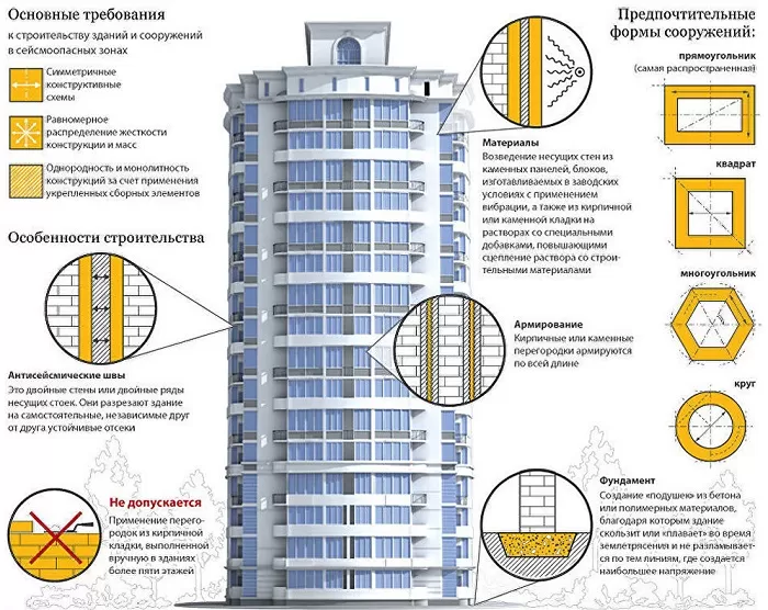
In the 20th century, the construction of special earthquake-resistant buildings of increased strength began in hazardous areas. Explanatory work is being carried out among the population on how to behave during an earthquake. Special safe areas are being created where it is best to stay during a natural disaster.
Unfortunately, it is not yet possible to predict an approaching earthquake with good accuracy, but scientific research in this direction is being conducted. There are seismic stations all over the world. Seismic activity reports are kept, maps of geothermal processes in the bowels of the earth are compiled, and forecasts are made based on these statistical data.
It has been noticed, for example, that before a disaster, radon gas is intensely released from rocks, which can be detected. The abnormal behavior of animals before a disaster is also being studied. The main harbingers of tremors can be fish and insects.
Earthquake areas
The uneven distribution of seismically dangerous zones on the world map is also associated with the peculiarities of the causes of natural disasters. In the Pacific Ocean there is a seismic belt, with which, one way or another, an impressive part of earthquakes is associated. It includes Indonesia, the west coast of Central and South America, Japan, Iceland, Kamchatka, Hawaii, the Philippines, the Kuril Islands and Alaska. The second most active belt is the Eurasian one: the Pyrenees, the Caucasus, Tibet, the Apennines, the Himalayas, Altai, the Pamirs and the Balkans.
The earthquake map is full of other potential danger zones. All of them are associated with places of tectonic activity, where there is a high probability of collision of lithospheric plates, or with volcanoes.
The Russian earthquake map is also full of a sufficient number of potential and active sources. The most dangerous zones in this sense are Kamchatka, Eastern Siberia, the Caucasus, Altai, Sakhalin and the Kuril Islands. The most destructive earthquake in recent years in our country occurred on Sakhalin Island in 1995. Then the intensity of the natural disaster was almost eight points. The disaster led to the destruction of a large part of Neftegorsk.
The enormous danger of a natural disaster and the impossibility of preventing it forces scientists around the world to study earthquakes in detail: the causes and consequences, “identifying” signs and forecasting possibilities. It is interesting that technical progress, on the one hand, helps to more accurately predict threatening events, to detect the slightest changes in the internal processes of the Earth, and on the other hand, it also becomes a source of additional danger: accidents at hydroelectric and nuclear power plants, oil spills in localities are added to surface faults. mining, terrible industrial fires. The earthquake itself is a phenomenon as controversial as scientific and technological progress: it is destructive and dangerous, but it indicates that the planet is alive. According to scientists, a complete cessation of volcanic activity and earthquakes will mean the death of the planet in geological terms. The differentiation of the interior will be completed, the fuel that has been warming the interior of the Earth for several million years will run out. And it is still unclear whether there will be a place for people on the planet without earthquakes.
Why do earthquakes happen?
There are few reasons - only two. The first is related to the work of the so-called Internal Forces of the Earth. The second is human activity. This type of earthquakes appeared quite recently, but their intensity, expressed in points, is ready to “compete” with Natural tremors of the “firmament”.
Earthquakes created by Nature
The origin of natural earthquakes easily overlaps with Wegener's theory of the movement of lithospheric plates. In summary, it looks like this – the earth’s crust is divided into giant plates. A bit like a cracked shell on a hard-boiled egg. Only lithospheric plates are much larger. Moreover, they are not rigidly fixed, but constantly move one relative to the other.
Movement can be in horizontal and vertical directions. This is possible due to the fact that the blocks of the earth's crust are located on a plasma-like, relatively liquid layer of magma - the asthenosphere.
And now the most important thing is that any interaction of lithospheric plates is accompanied by the processes of tectonism, volcanism and seismism. Particularly strong tremors of the earth's crust occur during rapid horizontal movements - counter and explosive.